Myanmar - what country is it? Where is it located on the world map? Where is Burma? Republic of the Union of Myanmar: geography, population, language, religion Do you need a visa to enter Myanmar?
(Union of Myanmar)
General information
Geographical position. Myanmar is a country in Southeast Asia. It borders on China in the north and east, Thailand and Laos in the east, and Bangladesh and India in the west. It is washed by the waters of the Bay of Bengal and the Andaman Sea (in the south). The Western Arakan Yoma Range, up to 2,740 m high, forms a natural barrier between Burma and the Indian subcontinent. The Bilaukthong Range lies along the border with Thailand. The country also contains part of the Shan Plateau, the average height of which is about 910 m. The valley of the Irrawaddy-Sitang river system - the most fertile lands - occupies about 46,620 square meters. km.
Square. The territory of Myanmar covers 676,552 square meters. km.
Main cities, administrative divisions. The capital is Yangon. Largest cities: Yangon (3,851 thousand people), Mandalay (533 thousand people), Mawlamyine (220 thousand people), Sittwe (108 thousand people). Myanmar is a federation consisting of 7 national regions and 7 administrative regions.
Political system
Myanmar is under military rule. The head of state and government is the chairman of the State Council for the restoration of law and order. The constitution has been suspended.
Relief. In the east of the country there is the Shan Highlands, in the west there is the Arakan-Yoma mountain range, and between the mountains there is the hilly Irrawaddy Plain.
Geological structure and minerals. The country's subsoil contains reserves of oil, tin, tungsten, zinc, copper, lead, coal, natural gas, and precious stones.
Climate. Most of the country is located in the tropical zone. The hot season runs from March to October, and the cool season of northeast monsoons runs from November to February. The average temperature in the cool season is + 16°C, and in the hot season it exceeds +38°C. The rainy season, brought by the southwest monsoon, lasts from mid-May to October. The average annual rainfall in Upper Myanmar is about 890 mm and in Lower Myanmar it is about 5,080 mm. Inland waters. Large rivers - Irrawaddy, Salween.
Soils and vegetation. Forests cover about half of Myanmar's territory. In regions that receive large amounts of moisture, tropical forests contain rubber and oil trees, acacia, bamboo, coconut palm, betel nut, ironwood, cinchona, and mangrove. In the northern forests there are oak, pine and various types of rhododendron. Fruit trees such as citrus fruits, bananas, guavas, and mangoes grow in coastal areas.
Animal world. Tigers and leopards are common in the forests of Myanmar. Upper Myanmar is home to a large number of elephants (some of them domesticated), rhinoceroses, wild buffalo and wild boar, several species of deer and antelope. Small mammals include: gibbon, several species of monkeys, wild cat, tapir, flying fox. About 1,200 species of birds live in Myanmar, including parrots, pheasants, peacocks, and herons. Among the reptiles, the most common are crocodile, gecko, cobra, python, and turtle.
Population and language
Myanmar's population is about 47.305 million. The average population density is about 70 people per 1 sq. km. - one of the lowest in the Far East. Ethnic groups: Burmese (related to Tibetans) - 68%, Karens - 7%, Shans - 9%, Mons (Tala-in) - 2%, Chins - 2%, Kachins - 2%; each ethnic group lives in its own state: the Karen in lower Myanmar, the Shan along the Thai border, the Mon in the delta region, the Chin in the northwestern highlands, the Kachin in northern Myanmar along the Chinese border. Languages: Burmese (official), Shan, Karen, Moi, English, Chinese.
Religion
Buddhists (the majority belongs to the Theravada teachings) - 89%, Christians - 4%, Muslims - 4%, Hindus, pagans.
Brief historical sketch
The first known civilization in what is now Myanmar was the Mon civilization, which arose around 3000 BC. e. It existed for more than three thousand years, until 628 AD. e., when it was replaced by the Piu civilization. In the middle of the 9th century. The Burmese appeared on the territory of Myanmar, later the Shans, Karens and Kachins came. The first unified Burmese state was founded by King Anorata in the mid-11th century. in Upper Burma. In 1287, the kingdom of Patan was conquered by the Mongol conqueror Kublai (Sechen Khan). Burma was divided into two states. In the second quarter of the 16th century. With the help of Portuguese mercenaries, the Burmese Tongu dynasty managed to unify the country.
In the 19th century After three wars between the British and French armies, Burma became a British colony. In 1937, it received the right of self-government, and on January 4, 1948, the country's independence was proclaimed. Since 1962, a military regime has been introduced in the country. Under military rule that drove Indians out of government and excluded the Chinese from commerce, Burma became one of the poorest countries in the region. In 1989, the country's name was changed to Myanmar. On May 27, 1990, the first democratic elections in 30 years were held, in which the main opposition party won, but the military refused to transfer power.
Brief Economic Sketch
Myanmar is an agricultural country. The main food and export crop is rice; They also cultivate wheat and corn; from technical oilseeds, cotton, jute, sugar cane, tobacco, rubber. Cattle are used as draft animals. Harvesting valuable wood species. Fishing. Extraction of oil, non-ferrous metal ores (lead, zinc, tin, copper), silver, precious stones. Lead-zinc plant, oil refinery and metallurgical plants. Food-flavoring (rice-cleaning, oil-processing, sugar, tea, tobacco) enterprises. Production of silk and cotton fabrics, jute products. Handicrafts. Export: agricultural products, timber, minerals, precious stones, seafood.
The monetary unit is kyat.
Brief sketch of culture
Art and architecture. Myanmar is one of the most vibrant centers of Buddhist culture in all of Asia, with thousands of temples and pagodas. The country is often called the Land of Golden Pagodas. The most famous is the Shwe Dagon Pagoda, 100 m high and completely covered in gold. Among the many museums are the National Museum of Art and Archeology in Yangon and state museums in the cities of Mandalay and Mawlamyine.
Mawlamyine. Several pagodas; ancient caves. Pegu. Kuaikpyen, Shwe-guan, Shwemodo pagodas; a huge statue of a resting Buddha (994); The ancient city of Haltawaddy is nearby. Mandalay. More than 700 pagodas. Myinjan. Not far from the city are the ruins of the city of Pagan - the capital of the first state on the territory of Burma. Yangon. Peace Pagoda, built in 1952 to commemorate the 2,500th anniversary of the death of Buddha.
There lived the most ordinary boy in this world. And he had a grandmother in Veliky Ustyug, with whom he visited in the summer. The old woman lived in a small wooden house with a garden along with a couple of cats and a lazy dog. In my grandmother’s room there was a thick pot-bellied chest of drawers, a table and a hefty chest. What a miracle, you will say, and you will be wrong. One day, on a hot day, the old woman started dismantling this chest of hers. The boy, of course, was hanging around. And so, after coats, shawls, embroideries, old letters and documents were extracted from the depths, a secret was recovered from the very bottom in a long bundle. It turned out to be a sword in a patterned silver scabbard. In it, people in unfamiliar clothes, waving the same swords in their hands, were chasing a deer. It was a real Burmese sword. And - it started spinning... Did you recognize it? Reading this wonderful book “The Sword of General Bandula” by Kir Bulychov as a child, I first learned about Burma and the Burmese people.
Where is Burma
So where is Burma on the world map? It’s interesting that this question is asked on the Internet not so rarely. No, not in Africa. Although where it is located there is also hot sun, there are also bright colors. The place where Burma is located is South and Southeast Asia. This is one of the largest countries in the region; in terms of territory it occupies, it is second only to Indonesia. Burma stretches from north to south over a distance of two thousand kilometers. From the south it is washed by the waters of the Indian Ocean, and the other three sides are protected by rugged mountains. Two-thirds of the territory of the country itself is also occupied by mountains and jungle.
Burma on the world map
The countries bordering it are: in the north - China, in the west - Bangladesh, India, in the east - Thailand, Laos. It is here, where the borders of Burma, Thailand and Laos meet, that the famous Golden Triangle, a place for the production and sale of drugs, is located. By the way, these places are not only difficult to access, but also mysterious; there are eyewitness accounts of paranormal phenomena occurring there.
By the beginning of this century, a lot had changed on the world map. The name of this country has also changed. The British, and after them the rest of the Europeans, called this country Burma, but the Burmese themselves always called it Myanmar, this is its original name. Now it is called Myanmar. Or rather, the Republic of the Union of Myanmar.
Poverty and Wealth
Nature has generously endowed this country with riches: there is both gold and reserves of precious stones: the best rubies in the world, the purest soft green emeralds, delightful sapphires with a silky sheen, diamonds, aquamarines, cold-pure amethysts, citrines, beryls, jades are mined here , which are called jade here. Pink, black, and silver pearls are mined in the seas.
Among the jewels the Queen of England has is one incomparable, the so-called Burmese crown. It is made in the form of a wreath of roses with diamond petals, and in the center of each flower is a rosette, decorated with rubies with a mesmerizing dark red glow. The rubies were received as a gift from Burma.

Here, on the mines of Burma, painite was first discovered - the rarest precious mineral in the world, according to the Guinness Book of Records. It is a transparent stone whose color ranges from orange-red to red-brown. There are very few gem-quality examples of this stone, so transparent and intensely colored painites are practically priceless. And even now painites are found mainly only in Burma
The depths of Burma contain many minerals, non-ferrous metals, polymetals, coal, gas and oil.
It is here that teak forests grow, supplying teak wood that is in demand all over the world, used for the manufacture of luxury yachts, boats, as well as for the production of furniture, interior decoration, and flooring.
The untouched jungle has preserved many rare animals intact. For example, in the Burma Zoo there live three incredible pink elephants found in the deep jungle. Or rather, they have a light brown skin color, which turns pink when exposed to water. This amazing metamorphosis is observed by everyone when the elephant keeper waters his pets with a hose. Or the sneezing monkey, which has a snub nose and sneezes when it rains. Or the cutest red panda with a red tail and glossy black paws, whose fur is red on top and dark brown underneath. Or the small, angry biruang sun bear, a representative of an endangered species of the bear family. The forests are home to leopards, tigers, elephants, rare butterflies and birds...

The flora of the country is extremely rich and diverse; more than seven hundred of the thousand known species of rhododendrons, many species of orchids, camellias, and palm trees are found here.
Many discoveries still await geologists, botanists, and zoologists in this unusually rich country, since not all of it has yet been studied and explored.
However, this richly endowed Myanmar is one of the poorest countries in Southeast Asia.
Meanwhile, until the middle of the last century, while under British rule, Burma was the richest and fastest-growing country in this region. But after independence came years of military rule, regime succession, disastrous economic reforms of Burmese socialism, years of international isolation, EU and US sanctions that quickly turned Myanmar into an economically insolvent, least developed and poor country.
Treasures of Myanmar in numbers
- 90% of the ruby market worldwide
- 12.3 million hectares of arable land, with rice grown on more than half of this territory
- 0.5 billion barrels of oil reserves
- 2.0 trillion cubic meters m gas reserves
- 75% of teak wood worldwide
What century is it now?
Now, being in Burma, one can quite imagine that the 21st century in the yard has remained somewhere very, very far away, or has completely melted away from the Burmese hot sun, and the nineteenth century still continues its unhurried existence. People farm by hand, there is no mechanization, they move on horse-drawn carts, and live in hut houses. The country has power outages and lacks roads. Mobile communications and the Internet are in their infancy. The bulk of the population is employed in agriculture, the average level of education is four grades...
Myanmar is a country in Southeast Asia, located in the west of the Indochina Peninsula. Its neighbors on the eastern border are Thailand and Laos, in the northeast and north the country borders on China, in the west there is a triple neighborhood - India, Bangladesh and the waters of the Bay of Bengal, and the southern borders are reliably protected by the waters of the warm Andaman Sea.
Myanmar on the world map
The capital of the state until 2005 was the city of Rangoon, then, most likely for security reasons, it was moved to Pyinman, located 320 miles from the former capital. But the story of the capital did not end there either; in the same 2005, the country’s leadership chose a place near Pyinman for the construction of a new capital, which on March 6, 2006 was officially named Nay Pyi Taw.
So, the capital of Myanmar is the city of Naypyitaw, located almost in the very center of the state. In addition to Naypyitaw, the only two cities in the country in terms of population are Mandalay and Mawlamyine (550 and 220 thousand people, respectively).
Either the constantly changing government, or the love of change, but the name of the country has also changed more than once in a very short time. In 1989, the state, which until that time the whole world knew as the Union of Burma or Burma, was renamed the Union of Myanmar, and in 2010 the country began to be called the Republic of the Union of Myanmar.
But, despite the systematic transfer of the capital and changes in the name of the state, its administrative division has remained constant since 1974. The country consists of 7 states and 7 administrative regions, which in turn include cities and rural areas.
The country is rich in water resources; many rivers flow through its territory, the largest of which are the Irrawaddy, Seatown, Meklng, Salween and Chindwin. The main geographical and natural attraction of the country is the Irrawaddy River, which is 2,150 km long and flows throughout Manyama, from its northern borders to its southern borders. Flowing into the Andaman Sea, the Irrawaddy is divided into many large and small branches, creating a huge delta with an area of 30 thousand square meters. kilometers.
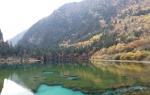
As for lakes, there are very few of them, but the large Inle Lake, located on the Shan Highlands, at an altitude of 1328 km above sea level, surrounded by mountains with snow-white peaks, is the main center of tourism in Manyama.
Map of Myanmar in Russian
Myanmar occupies a vast territory of 678 thousand square meters. km, which is why the climate of the country cannot be described unambiguously, but in general the country is dominated by the influence of the tropical and subequatorial climatic zones. In terms of weather conditions, three seasons are clearly defined: wet, lasting from the end of May to the end of October, then cool - from early November to mid-February and, finally, hot - starting in mid-February and ending at the end of May. During the hot period of the year, the temperature reaches + 41-43*C.
For those who do not really like or cannot tolerate heat, it is best to come to Manyama during the cool period, when the temperature is around +24-26 * C, the most pleasant time for both a beach holiday and sightseeing. Places that are definitely worth visiting are Mount Pope, a volcano that died out more than 250 thousand years ago, and the town of Kalo, from where you can easily reach the villages of the mountain tribes, which have preserved their customs and way of life to this day. And of course, the Pindaya cave complex, where there are about 1000 Buddha statues, will leave an unforgettable impression. Photo materials used from Wikimedia © Foto, Wikimedia Commons
Where is Burma on the world map. Detailed map of Myanmar in Russian online. Satellite map of Burma with cities and resorts. Myanmar on the world map is a country in Southeast Asia, located on the Indochina Peninsula. It is washed by the waters of the Andaman Sea and the Bay of Bengal.
The capital is Naypyitaw, the official language is Burmese, which is related to Chinese and Tibetan languages. Also in the country, many residents speak Chinese and English. A significant part of the country's territory is occupied by mountains, with the highest point being almost 6,000 meters.
Map of Myanmar in Russian with resorts:
Myanmar - Wikipedia:
Population of Myanmar- 53,259,018 people (2013)
Capital of Myanmar- Naypyitaw
Largest cities in Myanmar- Yangon, Naypyitaw, Mandalay
Myanmar dialing code - 95
Internet domains of Myanmar- .mm
Myanmar Climate subequatorial. In the hottest summer, the air warms up to +40 C. In winter, Myanmar is also quite hot, with average winter temperatures of +28...+31 C. It is much colder in mountainous regions, where frosts often occur.
Myanmar is rich sights, and many historical monuments in the country have been preserved since archaic times. One of these attractions is the Shwedagon Pagoda, which is located in the city Yangon and is the oldest stupa in the world.
There are other pagodas located near Yangon: Maha Visaya Pagoda, Sule Pagoda and Chaukhat Kui Pagoda. In the latter you can see the world's largest marble statue of Buddha. Another city in Myanmar that deserves attention is Bagan. Once upon a time, there were about 13 thousand unique structures on its territory. Today, the city has more than 5 thousand cultural and historical monuments, pagodas and temples.
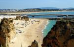
With access to the sea and the bay, Myanmar has everything you need for a great beach holiday. The most visited resort in Myanmar is Ngapali, located on the shores of the Bay of Bengal. It is especially popular among tourists due to its cleanliness - it is one of the cleanest beaches in the world. Other resort areas of Myanmar- Chang-Ta, Po-Kalar and Letkokon.
What to see in Myanmar:
Shwedagon Pagoda, Ngapali, Damayanji Temple, Mount Popa, Irrawaddy River, Chaittiyo Pagoda, Mrauk-U, Mahamuni Pagoda, Sulamani Temple, Inya Lake, St. Mary's Cathedral, Kandawgyi Lake, Karaweik Hall Floating Restaurant, Pindaya Caves, Mandalay Royal Palace, Maitau Village.
Unfortunately, not every person knows where a country like Myanmar is located. Previously, this state had a different name - Burma. The country was renamed in 1989. Almost like the USSR, this state unites several dozen nations at once. Myanmar is a country that opens its doors to tourists gradually, surprising them with a large number of monuments and attractions.
Consider in more detail what the state of Myanmar is, where it is located on the world map, what tourists who come there should see.
Myanmar: Wikipedia
- The official name of the state is the Republic of the Union of Myanmar (Myanmar);
- Previously, Myanmar was called Burma;
- The word "Myanmar" is translated as "fast", "strong";
- The capital of Myanmar is Naypyitaw;
- The area of the state is 678 thousand square kilometers;
- The country's population is 60 million people;
- The official language is Burmese (Myanmar);
- Religion - Buddhism.
Myanmar on the world map
Where is Myanmar on the world map? This country located in southeast Asia and is located in the west of the Indochina Peninsula, on the adjacent part of the mainland and on a number of coastal islands. From the west the state borders with Bangladesh, in the northwest - with China, in the northeast - with China, in the east - with Laos and Thailand. On the southwestern and southern sides, Myanmar is washed by the Bay of Bengal and the Andaman Sea. The state includes 7 national regions and 7 administrative regions.
Climatic features
Myanmar is a country with high mountains and impenetrable jungles, with a large number of mysterious Buddhist temples, and, of course, with the snow-white smiles of the local residents. Here is the famous Shwedagon Pagoda and the picturesque Inle Lake. These places can enchant anyone for life. Many who have been here at least once dream of visiting this piece of paradise again. The most famous resorts in Myanmar:

These resorts are now starting to give more competition to the most famous Thai resorts.
As for the climatic conditions in Myanmar, they are of a tropical monsoon nature. The southern part of the state is located in the subequatorial climate zone. Monsoons, which are typical for this area, form three main weather patterns season:
- The first weather season lasts from November to February. At the same time, the average daily temperature does not rise above +25 degrees. This weather is considered very cool for this area. It is during this period that the likelihood of dust storms occurring in the country increases.
- The second weather season can already be considered hot. It starts in March and ends in May. During this period, the air temperature rises above +33 degrees.
- The third weather season is the rainy season, which begins in June and ends in October. It is during this period that you should not plan a trip to Myanmar.
Nature of Myanmar
The main part of the country consists of high mountain ranges that are included in the Himalayan mountain system. Mount Habako Razi is the highest point not only in Myanmar, but throughout Southeast Asia. The height of this mountain is 5881 meters above sea level. Due to climatic conditions, the mountain ranges are abundantly overgrown diverse plant species, which attracts many ecotourists from all over the world.
The central part of the state is covered by beautiful and unique beds of the two largest rivers in Myanmar:

There are several national parks in these areas. Myanmar is also home to famous mountain reserves, where tourists can get a closer look at the unique local nature. The most popular places among tourists:
- Lampi Island, which is located in the Andaman Sea;
- Mountain reserves Shaedaun and Pidaun.


Main attractions of Myanmar with photos
The country's most famous attraction, which attracts many tourists every year, is Yangon. Shwedagon Pagoda. This landmark took 2,500 years to build and features an almost hundred-meter-tall spire that is adorned with over a thousand precious stones and gold platinums. The large sculpture of the reclining Buddha brought great fame to the temple. Its length is almost 55 meters. This pagoda houses the four hairs of the Buddhist spiritual master. An interesting fact is that the pagoda is still active today, so all Buddhist pilgrims can visit these great relics.
 Yangon itself- This is a park in which there are beautiful ponds and lakes. This city is also considered the best place in the whole country for a family holiday with children. Here, kids can spend hours frolicking in the local amusement parks.
The cultural center of the country is the city Mandalay. Many people come here to see the following attractions:
- Shwenandaw Palace;
- Mandalay Hill;
- City of Ave;
- Amarputa city;
- Sagaing city.
In the former Burma there are world-famous and unique temples in the city of Bagan, where you can feel the whole atmosphere of extraordinary and mysterious Asia. Thousands of ancient pagodas and temples are concentrated here, located on an area of 42 square kilometers, which can fascinate foreign tourists.
When traveling to Burma, it is imperative to plan a visit to the picturesque Inle Lake, in the center of which stands the Monastery of Jumping Cats. There are still six monks there who teach cats to perform amazing tricks in front of tourists. This place has become famous not only for the cats, but also for the fact that local residents organize a floating market here every week. At this market you can buy various souvenirs, just like at a regular market.
Entertainment and relaxation
Most often, tourists come to the former Burma to soak up the sandy beaches. beaches. The best beach area is Ngapali, which is distinguished by its delicate white sand, a large number of first-class hotels and excellent restaurants. More and more tourists from all over the world come to this paradise every year.
Another equally attractive resort in Myanmar is Ngwe Saung, which is famous for its ideal beaches with beautiful tall palm trees. This place ranks second in popularity among tourists. However, every year the influx here only increases.
It is worth noting that active Holidays in Burma are not yet as developed here as in many countries of the world. However, here you can ride bicycles with a group and look at the local beauty. Hiking and unforgettable safaris through local national parks and reserves are very popular.
 Fishing lovers can also safely go on holiday to Burma, because here you can get new unforgettable experiences from catching big fish near the beaches of Ngapali.
It is also worth visiting the famous “Elephant Camp”, which is located near the Ngwe Saung resort. It's cheap here take a ride on a real Indian elephant. Many tourists go to the new Ngalaik water park, which is located in the vicinity of the capital.
Many people call Burma the “Land of Golden Pagodas”, because they are literally everywhere here. That is why most excursions are organized around these attractions.
Capital Naypyitaw on the map
The capital of Myanmar is located on the Seatown River. The city is located in the very center of the state. The population of the capital is 900 thousand people.
Naypyidaw is a modern metropolis that boasts unique structures that have no analogues in the world. Uppatasanti Pagoda is one such place. In its center there is a column, around which there are four Buddha statues, which are made of jade. Their gaze is directed to different directions of the world.
In the center of the capital there is a sculptural composition dedicated to the rulers of Burma.
The local zoo is also considered one of attractions capital Cities. This zoo is located on the outskirts of the city and, by the way, is the largest in the entire country.
Excursions to various natural attractions are organized from Naypyitaw:
- To Inle Lake;
- To the Bagan temple complex;
- To the city of Mrauk-U.
It will be very interesting for tourists to attend the capital’s holidays. Fans of pompous events should attend the local film academy awards ceremony. In April, local residents here celebrate Tinjan - a New Year's water festival, which, according to tradition, is very reminiscent of the Russian Ivan Kupala Day. On this day, it is customary to douse yourself with water from various containers and water pistols. This lasts for five days.