Ak-Baur neolithic temple complex. Kalbinsky ridge
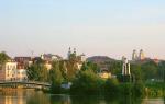
Kalbinsky ridge - low, but amazingly bizarre mountains that continue Altai beyond the Irtysh. Well, the Irtysh, flowing from China, was once the border of Kazakh nomads: the Kazakhs mastered the lands on its right bank under Russia. The previous owner of the right bank and the entire Altai, Buddhist Dzungaria, itself has repeatedly tried to gain a foothold in the left bank steppes. So, while bypassing Ust-Kamenogorsk, from the shown mountain Ridder, the Russian city of Kazakhstan itself, we will descend to the primordial Kazakh land of the Kalbinsk mountains. The southern outskirts of Ust-Kamenogorsk are one of the most interesting corners of the endless Great Steppe: in one day, even without our own transport, we managed to visit the ancient (really ancient) observatory Ak-Baur, the amazing landscape of the Sibin lakes and the ruins of the Buddhist monastery Ablaikit.
You can take a bus from Ust-Kamenogorsk to both Ak-Baur and the Algabas aul near the Sibinskie Lakes, but looking at the schedule on the Internet, I realized that it didn’t suit me in any way. Therefore, early in the morning we took a city bus to KShT (an area on the southern outskirts of Uskaman near the former silk fabric factory) and soon caught a car. This road itself is called the Samara highway, and leads in the opposite direction to the real Samara. More precisely, to the large village of Samarskoe and further to the Kaznakovskaya ferry across the Irtysh - in the steppe country, it turns out, there is a place for a ferry. Beyond the Irtysh, this road would lead us to a remote corner behind Lake Zaisan, where there are colorful rocks Kiyin-Kirish, South Siberia and Central Asia are intricately intertwined in landscapes, and China is within easy reach. Not that day I was going there, but at the end of the trip I was so tired that I just waved my hand. About 50 kilometers from Ust-Kamenogorsk is the village of Mamai-Batyr - until 2010 Vasilyevka, the birthplace of Viktor from Krasnoyarsk, who gave me a lift months earlier. Here the road forks - Samarskoe and Ak-Baur to the left, Algabas and Sibinskie lakes to the right. We caught the car according to the principle "where it goes, we'll start there", and since the Samara road is more busy, after 40 minutes we were already standing at the foot of Sorokin Mountain (844m). The steppe near her - this is Ak-Baur:
Kalbinsky ridge and Kolyvan - the names are very similar, and there are even more similarities in the landscapes (see, for example,). Wasn't this name common to all the steppe foothills of Altai, where Nature created a museum of natural sculptures?
Among the grass and dung are white quartz stones, slightly shimmering in the sun:
Our goal is on the other side of the track, under the Korzhimbai mountain (801m). The sonorous name of the tract is translated as "white liver", but allegorically "baur" is an affectionate appeal to the younger brother, who apparently was Korzhimbai in relation to Kyzyltas - that is, Sorokin Mountain. In the morning it is not white in any way - two mountains stand almost strictly along the summer "route" of the sun through the firmament.
The first impression was the long rocky "walls" stretching, winding along the hills, in the direction of Korzhimbai:
We went along these walls. I knew that at the foot of Korzhimbay there should be a grotto with petroglyphs of the Stone Age, but from other people's photographs I roughly knew how the observatory and the smelting furnace - other ancient monuments of Ak-Baur - looked like. I also knew afterwards or in the Russian Altai that there was a very great risk of not finding anything, simply not seeing it at close range. But after crossing the ridge, we saw that the foot of Korzhimbai was surrounded by a fence, which means that in small houses near the gate, of course, they will take money for the entrance, but they will orientate where and how to go. Everything turned out to be even simpler - the fence is hung with stands with a scheme of the tract, trails to the sights have been trodden, and the grotto itself with petroglyphs is even equipped with a sign. And, perhaps, if it had not been, we would never have found anything: this is not even a grotto, but just a crevice under a stone.
But rock paintings can be discerned even from below. Unlike all the other petroglyphs that I showed earlier, they are not carved into the stone, but painted with red ocher:
On the slippery, sloping, polished stones, you can climb and examine them up close. The "canopy" of the grotto is distinguished by its amazing shape:
These petroglyphs are one of the oldest in Altai, and in Kazakhstan, maybe just the oldest - written in the Stone Age, 4-5 thousand years ago. There are about 80 drawings in total, and if in some you can guess the outlines of people, goats or carts, then others seem to be just signs, maybe even ancient letters? Something similar, and also in the gap under the stone, was preserved on the rock Kamennaya Mogila in the Ukrainian Black Sea region, and in both places - the oldest writings post-Soviet space... Of course, all the decryptions of these signs are just hypotheses, but if Ak-Baur was an observatory, aren't these petroglyphs its "key", instructions for working with the instrument?
Modern visitors do not have ocher, so other drawings and inscriptions in the grotto, although made by savages, are no longer from the Stone Age.
On the "roof" of the grotto there are many strange hollows in the form of bowls. Are they artificial or natural? On Ak-Baur there are both:
I climbed onto the "roof" only to look into the "window" of the grotto from above. As you can see, it is rather cramped, and the same petroglyphs can only be viewed while lying down. Perhaps they were applied where, by turning his head, the shaman could project this instruction onto the terrain.
Going down, we realized that we had examined the petroglyphs at the right time - towards the museum caretaker in shabby camouflage, he was leading a group of schoolchildren, which PAZik from Ust-Kamenogorsk brought to the gate. The schoolchildren were both Russians and Kazakhs, but all of them were Russian-speaking without an accent, and unlike many other school groups, they did not use foul language and did not poke fun at each other. Most of all I was interested in the question of how they fit in the grotto:
There are a lot of rock sculptures here - this stone bird, for example, walks along the road from the entrance to the museum to the grotto:
But main rock Ak-Baura - here. This is the ancient observatory, and the gaps in its stones interacted with the Sorokin Mountain and the heavenly bodies passing over it. It is believed that they observed the Sun, Moon and the constellation Capricorn from here. Next to the natural rock is a small "wall" of stone slabs, laid strictly from west to east. Perhaps one of her stones served as a vizier to the Pole Star.
The ancients watched the sky, of course, not from a great craving for knowledge, but because having learned to plow the land and graze livestock, man realized that he became even more dependent on the change of seasons than before. Thus was born astronomy, the oldest of the natural sciences after biology, and as in our time, at the end of the Stone Age, the Cosmos served the Earth.
Nearby are some more stones with holes. Theoretically, there are the remains of a sundial, the foundations of primitive buildings that have piled up the "walls" of the plates with a sight to the Big Dipper ... Observatories inevitably became temples, where they not only watched the movement of celestial bodies, but also asked for their favor.
The peak-rock in the frame above is also an ancient smelting furnace, much more powerful than on Kuehtonarka. A sort of prehistoric Magnitogorsk:
Furnaces in those days were disposable, after smelting they were opened, and this stone served as a convenient "stand" for them, and in their free time from metallurgical affairs, it was apparently also used by astronomers: a boulder with a chain of holes was pushed to the rock, onto which the sun's rays from under it " visor "fell on certain dates:
There are also, in theory, a lot of not so ancient ("only" 2-3 thousand years old) petroglyphs, more familiar in Altai and in Central Asia horses, deer and rams, but no matter how much I looked at the stones, I did not notice a single one. A lot of their photos or. Below is a lonely white stele, about which I did not find any information at all - perhaps it was placed vertically quite recently. And over all this, and over a couple of winter quarters in addition, Sorokin Mountain reigns:
We were accompanied by a charming donkey, which could well master human speech, if there was a Hodja Nasreddin here:
Horses were taken out of the wintering grounds:
On the way to the highway, a viper came across:
And along the highway under Sorokin Mountain there are Kazakh necropolises:
And, but in Altai they are arranged noticeably differently ... but we will get there later.
Along the track, gradually shifting along the necropolises to more convenient place, we stood for an hour and a half or two. The fact is that the road here is straight, the asphalt is generally decent, and therefore the overclocked cars could not be slowed down. My mood has already started to deteriorate - I had to pass something 10 kilometers back, before turning to Algabas in the former Vasilyevka, but this is the distance that is nothing for a car, and walking is long and boring. In the end, the police stopped next to us, but not even to check the documents, but how to find out in a civilized country if everything is in order and if we need help. Having found out where we need to, they stopped the car and put us there, and the owners of the car - the driver and two intelligent Kazakh women-passengers were so glad to us that maybe they would have stopped themselves. Mamai-Batyr, the former Vasilyevka, is unmistakably recognizable by the lone "Ottoman" minaret against the background of the steppe.
And we didn’t stand at the turn for even five minutes, when we were picked up by a car with three Kazakh men, who were traveling not even to Algabas, but straight to Sibiny, to build a dacha there. Well, what is Sibinskie lakes? The most popular place recreation for residents of smoky Ust-Kamenogorsk, where in the summer there is even a direct bus. Best of all, their device, along with the tricky squiggle of our route, can be understood on a satellite image: Sorokin Mountain above Ak-Baur is the northern end of the rocky spur of the Kalbinsk mountains, and at its southern end there are five narrow valleys, in which the Sibins are located. Although it is possible to get here through the Targyn village on the Samara highway, the village Algabas is traditionally considered the "gateway" of Sibin, from which their numbering begins: First Lake Sardykol, Second Lake Tortkara, Third Lake Shalkar, Fourth - Korzhinkol and the smallest Fifth - Karakol (Black). , other names are given (Istykla, Dyuisen, Ulmeis, Alka, Kashkerbay), and I do not know which of them is more correct and where this discrepancy comes from. We drove to the Third Lake:
From the road connecting Algabas with Targyn, the lakes are not visible - only mountains, as if covered with giant scales:
Even in the memory of our generation, the Sibins were a deaf and wild place. Today's residents of Kamenogorsk spit at their mention - but they drive: from a prosperous and educated city, people smoke "Kazzinc" and "Ulba" whenever possible. Sibins are gradually turning into a "home" resort of Ust-Kamenogorsk, as for Astana, for Karaganda, Bayan-Aul for Pavlodar ... They say that this process began from the Second Lake, but in the end all of them were overgrown with tourist centers and summer cottages.
At the end of September, they were safely empty - we did not see any vacationers here at all, only someone was building or cleaning up somewhere:
Shalkar (or Ulmeis) is the largest of the Five Lakes (3 by 1.2 km), and on that shore there is probably the only nudist beach in Kazakhstan and Central Asia. At first, mostly tourists sunbathed on it, and then the Kamenogorsk people pulled themselves up, at which the local Kazakhs chuckle into a fist. Small lakes in stone bowls should warm up well, but they also feed their springs, so at the end of September the water is already icy.
The guy on the floating mower turned off the engine at the sight of us and greeted us. He cleared the bank of the grass, which this machine uprooted, plowing the bottom. They brought here a machine exotic for the steppe country from Tver.
After passing the village and the rocky "tongue", we went to the Fourth Lake Korzhinkol (or Alka), which seemed very small:
But there are bridges over its transparent water:
And tourism is brought to new level- an amusement park is being built right above the water. I was told that there was a rope stretched from rock to rock above the lake, along which it would be possible to ride on a special bungee. Or maybe dive from it - the depth of the Sibinsky lakes (I don't know which one is specific) is up to 38 meters. Extreme recreation has been practiced here for a long time - in clear water you can not just fish, but engage in spearfishing:
After resting and having a snack in the Korzhinkol pavilions, we went along the lake. It gradually became clear that it was not small, but had the shape of a cunning squiggle - an extreme park was being built on a bay almost parallel (!) To the main part of the lake. On the cape, if you look closely, you can see cormorants - not only people know how to hunt here under water.
To complete the picture, I decided to admire the Sibins from above. Usually for this they climb their scaly rocks, but I decided that best view will open from the prosaic rolling hills opposite. Apparently, such a thought occurs to few - there are no paths upstairs, and the same Olga could not climb with me through the thorns, because she was in sandals. This is how Korzhinkol looks from above, but the angle of view disturbs the perspective - in fact, "along" the frame, the lake is about one and a half times longer than "across".
Cape from a slightly different point. There is something unreal in this landscape:
View towards Targyn, behind the nearest spur the small Fifth Lake Karakol:
The view towards Algabas is much more interesting - other lakes turn blue behind the ridges of the rocks. The very prospect of the capes is very reminiscent of sea coast, some Fiolent, but only on the "curly rocks", polished sheep's foreheads, it is clearly visible that a glacier has worked here.
The narrowest "wall" between the lakes is less than 250 meters. In general, it is an amazing place, the beauty of which no tourists can trample. And it's pretty clean here - apparently, they are cleaning up:
Coming down from the hill, I was already determined to walk to Algabas (even though its name means Step Forward in translation), but suddenly we were picked up by a car driven by an intelligent middle-aged Kazakh - as it turned out, the director of the House of Culture in the neighboring village of Bozanbai. Of course, he invited us to the museum at the Palace of Culture, but he understood that today we will not be in time, and there are more important things to do in Algabas - under that mountain, at the last Cape of Sibin, on the site of the non-existent "zero lake", are the ruins of a Buddhist monastery Ablaykit... Everyone who gave us a lift advised to go there, especially since "there are now Americans" - an international archaeological expedition. The extreme mountain of the Sibin ridge is perfectly visible from Algabas:
But the director of the recreation center dropped us off not at the most convenient path, but at the shortest. The problem is that the branches of the Sibinka River begin immediately behind the aul. The first two we crossed over gates and pebbles, but the third one could, without wetting our shoes, only wade. I desperately did not want to take off my shoes and soak my feet in not the most clean water, but then a ZIL-hay truck rolled out of the aul, thundering with an empty body, and, waving at it, I shouted to the people in the cab, "Take it over the puddle!"
It was unrealistic to get into the back of the car, Olya found a place in the cockpit, but I hung on the step, holding my hand to the mirror and the edge of the door. The Kazakhs not only transported us through a puddle, but also threw us almost to the goal, but I remembered the kilometer on the hanging for a long time, firmly deciding not to agree to such an offer next time. We left ZiL in the middle of a mown field, over which mountains hung like frozen fire. Now all that remained was to find a crossing over another river, go around the rock with a tourist to the cape and see the ruins of the datsan.
In Kazakhstan, at least one more Buddhist monastery is known near Karkaralinsk and rock paintings near Alma-Ata. And starting the story about the Kazakh Altai, it will not be superfluous to recall the history of the Dzungar-Kazakh wars. Or - Kazakh-Mongolian: the name "Dzungar Khanate" comes from the Mongolian Zuun-gar, which means Left Hand. Its inhabitants called themselves Oirats, while the Russians and Muslims knew the Kalmyks: it was something like a distant Dzungarian colony on fertile and warm lands. In the 1630s, in the war between several Mongol tayshi (princes), which was unleashed by the prince of the Choros tribe Khara-Hula, an alliance of Choros, Torguts, Derbets and Khoshuts was formed under the rule of Erdeni-Batur, the son of Khara-Khula, who secured the support of the Dalai in Tibet. Llamas. In 1640, at the general kurultai, the tayshi adopted the Steppe Code (a set of laws of the new state), established Tibetan Buddhism as their common religion, with the help of the missionary Zaya Pandita adopted the new alphabet "todo-bichig", and began to do what the Mongols were best at. in the world - to conquer the world. For the next hundred-odd years, Dzungaria haunted all its neighbors, China, and the Russian forts in Siberia, and the Central Asian khanates suffered from Kalmyk raids, but most of all - the other master of the Great Steppe, the Kazakhs. And here it is worth saying that the "Turkic" and "Mongolian" halves of the Great Steppe are actually two different worlds, the similarities and differences of which are only reminiscent of the two Americas. Century after century, both steppes gave rise to nomadic peoples, who went east, then west, starting with the Scythians and Huns, and the Kazakhs with the Dzungars were the last in this chain. Their war went on with varying success. By that time, the Kazakhs did not have a single state, therefore, the Dzungars more often prevailed. But then another khan died in Dzungaria, his sons and brothers began to fight for the throne, the Dzungars lost their unity - and the Kazakhs defeated them. Suffice it to say that Semipalatinsk arose on the site of the Mongolian city of Dorzhinkit, destroyed by the Kazakhs back in the 1660s. But civil strife ended, and the Dzungars again prevailed. One of the most impressive places of the Great Steppe is through which they invaded the Turkic steppe.
Dzungaria reached the pinnacle of power at the beginning of the 18th century: Tsewang-Rabdan, who ascended the throne in 1697, began an offensive on all fronts, under him the Oirats even burned Russian forts, held Tibet in 1715-20, and in 1716, defeating a detachment of Cossacks of Ivan Bukhgolts in the area of present-day Pavlodar, he captured a very valuable prisoner: before that, the Swedish engineer Juhan-Gustav Renat, already captured by the Russians, became the "Mongolian Archimedes", and after spending 12 years among the nomads, he established the production of guns and rifles for them. But Tsewan-Rabdan was especially active in fighting the Kazakhs, without interruption for 27 years, and this period for the Kazakhs was something like our Great Troubles: the Dzungars took Turkestan and Tashkent, held the Semirechye and Kyrgyzstan, even beat the Karakalpaks near the Aral Sea. However, the Mongols were ruined by too much commitment to war: famine reigned in the khanate, the Uighurs regularly rebelled, by 1720 the Chinese drove the Dzungars from Tibet, and the Russians from the Irtysh. Tsewang-Rabdan died in 1727, in 1729-46 his work was successfully continued by Galdan-Tseren - however, he no longer had forces to fight with Russia, the wars with China ended in diplomatic concessions from the latter, but not in territorial gains, and only with With the Kazakhs, Galdan-Tseren fought so successfully that the Younger Zhuz took over the protectorate of Russia in 1743. In 1731, the large noyon Lozon-Tseren with his people went to the Volga, and in 1733 Juhan-Gustav Renat left Dzungaria. The Kazakhs under the leadership of Khan Abylai (I wrote about him and) again began to gain the upper hand ... and they probably would have fought until the end of centuries, but in 1756 Dzungaria was captured and destroyed by China under the rule of the Manchu Qing dynasty, after which both the Kazakhs and the remnants The Oirats (including the last prince of Amursan, who was later buried in Tobolsk) turned to Russia for help - so Altai was included in it. The Dzungaria of the Manchus gave the Chinese name - Xinjiang, which means "New Border".
But even before the Kazakh khan Abylai there was a Dzungarian taishi Ablai, Erdeni-Batur's son-in-law, who went with him in 1643 on the first campaign against the Kazakhs. Ablai also made friends by correspondence with Alexei Mikhailovich, established diplomatic relations with Russia, let Russian ambassadors to China and even tried to find the legendary Armor of Ermak, the main relic of the conquered Siberia. In 1654, he moved his residence beyond the Irtysh, to the Sibinsky lakes, and the very name Ablaykit is nothing more than Ablai-Khiid, that is, the Ablai Monastery. In a nomadic country, monastic cloisters were the most important settled settlements, and Ablaykit was, in fact, a monastery-castle in a well-defended place. There was even a supply of fresh water - a small "hanging lake" somewhere in the folds of the rocks. However, already in 1671 Ablaykit became empty after another internecine war, in which even Russia turned its back on Ablai - her ally inevitably became Taishi Ayuka, the leader of the Kalmyks who settled on the Volga, and one of Ablai's enemies. However, it was against the rules to destroy the monastery, therefore, having taken Ablaykit, the winner of that war, Galdan Bosogtu, simply took the monks away from here. Even at the end of the 18th century, Ablaykit retained its integral appearance - here on the left is a temple, on the right the ruins of the Ablaev Palace, so it can be assumed that it was not time that destroyed it, but a fire or dismantling for building materials.
Nowadays, Ablaikit has the attributes of a tourist attraction up to information stands in three languages ... but there is no normal road. We hoped to talk with archaeologists, but they also filmed and left a couple of days before us. So we wandered alone through the huge (half a kilometer in diameter) ruins - behind the gates, from the picture before last, a few dozen meters to the former temple. He stood on a platform 80 x 45 meters, most of which was occupied by an open courtyard on a stone foundation:
Actually a temple with "stumps" of columns. Its dimensions were approximately 45 by 20 meters - the entire width of the platform, but only a quarter of its length.
Pallas found him almost intact in the 1770s. His drawing clearly shows a wooden frame - maybe the temple was destroyed by fire? As I understand it, no information about its destruction has survived.
Not a trace of Ablai's palace remained, and the residential buildings of the monastery were most likely yurts. Above the temple are the remains of workshops where bricks and tiles were fired:
Finds from Ablaykit in the Ust-Kamennogorsk Museum - tiles, faience, stucco and manuscripts similar to birch bark letters in Dzungarian "clear writing":
But as before, a natural pagoda dominates the abode:
We never got to the lake, all the more we didn't know exactly where to look for it. A similar hanging pool of rainwater on top of a cliff I. The wall encircles the monastery and right along the rocks, but we went down to the second gate with 4 steles in the corners.
A haystack on a tractor drove past the gate:
And on the way to Algabas we met a horseman. A few more horsemen passed in the distance - in general, the place here is not at all deaf:
There is a whole rocky city under the mountain next to the monastery. And the path turned out to be much drier - most of the streams could be crossed over pebbles, and only on the last one did we stumble - I walked normally in sneakers, and Olya had to take off her shoes in sandals.
I went up to the last house of Algabas with a stone shed unusual for Kazakhstan, and somewhere here we were picked up by a belated car to Ust-Kamenogorsk:
52.
... At the origins of the Turkic world.
... Deer breeding.
Kazakh Altai - there will be posts!
... City in Rudny Altai.
Sibinskie lakes and Ak-Baur.
Ust-Kamenogorsk. General flavor.
Ust-Kamenogorsk. Park Zhastar.
Ust-Kamenogorsk. Old city.
Ust-Kamenogorsk. Industrial areas and stations.
Ust-Kamenogorsk. Levoberezhny Park.
Ore Altai. Serebryansk and Bukhtarma.
Ore Altai. Zyryanovsk.
Katon-Karagay and Bolshenary. Kazakh Mountain Altai.
Bukhtarma. Korobikha, Uryl and back side Beluga whales.
Mongolian Altai - there will be posts!
Non-Altai Kazakhstan - see CONTENTS!
Alma-Ata. General-2017.
Alma-Ata. Talgar pass, or a trip over the clouds.
.
... Mounds, village and lake.
Astana. Miscellaneous-2017.
Astana. Continuation of Nur-Zhol boulevard.
.
Steppe Altai - see CONTENTS!
Ancient fortresses on the Silk Road of Kazakhstan.
“These brown lumps of porphyry,
These quartz on the crests of the hills
Every stone lies at the center of the world
Over the trampled dust of centuries "
Evgeny Kurdakov. “Ak-Baur secrets and discoveries. »Ust-Kamenogorsk. 2008 year.
Ethnographic drawings of East Kazakhstan.
It is on the slope of the Ak-Baur hill that the grotto of the same name is located with rock carvings made with red ocher (or the blood of sacrificial animals). In the vicinity of the village of Leninka, in the Ak-Baur tract, many rock paintings were found depicting a variety of animals - deer, horses, camels, argali, goats, snakes and, quite rarely, there are images of trees.
On the territory of the Ak-Baur complex, in its eastern part, there is a rocky ledge with petroglyphs. On this rock, besides the images of horses and goats, there are rock carvings depicting deer.
On the eastern side of the cliff, from the side of the rising sun, drawings depicting deer prevail. Why is it on this side and why is it a deer? Deer is one of the solar ones, i.e. solar images-signs (from Latin solaris - solar, sol - sun).
In many images in Eurasia, you can see a deer carrying the Sun on its horns, and the processes of its antlers resemble the rays of the sun. Drawings of horses, carved in Ak-Baur, are also very close in their semantics to deer.
The horse ... "due to its speed and racing power, has also risen to the symbol of the Sun or a draft animal of the heavenly chariot (Apollo, Mithra, the fiery chariot of Elijah)."
"Signs and Symbols" analyzes the materials of the Akbaur grotto, which are considered the most ancient writings in Kazakhstan. One of the chronological "bindings" can be a drawing - a symbol of a carriage shown above, on two disc-shaped wheels.
The date of the carriage from Akbaur is determined not only by the general similarity of the main structural elements with the Near Eastern, Central Asian, Caucasian and Yamno-Catacomb carts and their models, but also based on the analysis of symbolic signs centered around it and having close matches in images on ceramics, on terracotta figurines and other materials of the above-named regions.
Based on these data, a date can be proposed for the Akbaur cart - the end of the 3rd - the beginning of the 2nd millennium BC, although its correlation is not excluded. The scriptures of the Akbaur grotto represent the initial stage in the development of rock art of the paleometal era.
Closer to them - a series of inscriptions in the upper reaches of the Irtysh - Bukhtarminskaya, Manat, Sartymbet, near Lake Zhasybay, Draverta grotto and Tesiktas rock in Central Kazakhstan, at the entrance to the Karaungur grotto in South Kazakhstan.
"Symbolic signs of the Akbaur grotto: some aspects of the analysis" notes that the author, at the very beginning of the study of the inscriptions of the Akbaur grotto, attempted to find a pattern in the sequence of drawing drawings on the walls and ceiling.
The natural form of the grotto, as it were, corresponded to the structure of the temple-sanctuary in the open air, where people could perform ritual actions associated with some kind of festivities.
The natural depression in the rock, formed as a result of the weathering of granite, was associated with the organized space of the yurt-like dwelling and, accordingly, could be perceived as a “model of the world”.
The main reason that prompted some researchers to an archeoastronomical approach to the study of Akbaur's writings was the assumption that the sun's rays penetrating through the upper opening of the grotto could gradually illuminate different parts of the wall with drawings and create the effect of "animating" symbols.
The deer is one of the main and most sacred animals of the nomadic tribes of Eurasia. The beauty and strength of the animal, its peaceful disposition and ability to protect itself, the wide range of distribution of different subspecies, the annual growth of one antler appendage and many other signs contributed to the choice of the deer as one of the symbols of nomads.
Even the name of a whole people who lived in the Scythian time on the territory of Kazakhstan - "saka", some linguists translate as "deer". This image can only be understood on the basis of the general context of ancient culture.
In almost every large burial mound excavated by archaeologists (including in Chilikta and Berel), images of deer have been found made of gold, bronze, stone, bone and other materials.
Even more varied deer drawings have been found in petroglyphs Central Asia, the composition of the drawings as a whole reflected a certain area of the starry sky, which included the constellations Ursa Major, Dragon, Capricorn.
In general, supporting the conclusions of L.S. Marsadolova, O.O. Polyakova believes that the Pole of the Ecliptic should be located next to the image of the constellation of the Dragon, and points as such to a figure in the form of a cross with dots in a square, indicating a grid of coordinates with symbolic stars in the Ecliptic system.
Another symbol among the images of Akbaur is a cross in a square without dots, in her opinion, denotes another coordinate grid in the Equatorial system, tied to the axis of rotation of the Earth.
By combining modern map the location of celestial bodies with drawings of the grotto and using modern astronomical calculations, O.O. Polyakova determines the date of the appearance of the Akbaur symbolic signs - 1200 - 1100. BC.
There is no doubt that the population who lived here at the beginning of the 2nd millennium BC. (in the second half of the 2nd millennium BC, according to L.S.Marsadolov and O.O. Polyakova), he constantly observed natural phenomena - the movement of celestial bodies, especially the Sun and the Moon, knew the cycles of nature - the beginning of spring, vegetation and related behavior of wild and domestic animals.
Agriculture for them, although it occupied a secondary position, its development required certain knowledge about the phenomena of the environment. Symbolic, zoo- and anthropomorphic signs, as well as images of objects, are a kind of pictograms, predecessors of alphabetic writing, which made it possible to record, store and transmit information, experience and knowledge.
Along with the general mythologized astral-cosmogonic ideas, they also contained some knowledge of a pragmatic nature, not excluding astronomical ones, oriented to economic activities or necessary for carrying out cult-religious mysteries of the calendar cycle. The cone-shaped images from Akbaur are usually interpreted as signs-symbols of real portable frame dwellings, however in the context of semiotic status, i.e. significance, they can manifest themselves in the most unexpected and diverse associations that will pull along a whole chain of complex connections according to the principle: designating - designated / designating - designated / designating - designated.
In this case, the "hut-dwelling" may acquire a different meaning. This suggests that in a single syncretic sign system, complementary codes of different functions can be combined, which, on the other hand, can be considered as a pictorial mythological metaphor.
Researchers believe that not specific animals, people or objects themselves were reproduced on the rocks, but supernatural entities - souls, spirits, deities, i.e. myths embodied in images familiar to the ancients.
The possibility of interpreting some signs among petroglyphs as astronomical objects is not denied; such approaches have long been used in reconstructions. It is necessary to distinguish the archaeoastronomical aspect in the study of a pictorial monument from the problems of analyzing astral cults, in particular solar cults, and cosmogonic ideas, the roots of which go back to the depths of the Stone Age.
In this case, we are talking about methodological principles and different approaches to solving the problems of interpreting the semantic content of petroglyphs. The grotto and the adjoining site were used by the ancients for worship and corresponding ritual actions, possibly timed to coincide with certain calendar cycles, which, as indicated above, may have typological parallels in the ritual practice of Eurasian shamanism.
This does not exclude the reflection in the signs themselves and in the system of their mutual arrangement of some astral-cosmogonic ideas. The method of substantiating the later date of the Akbaur signs also does not stand up to criticism, since the very initial position itself is fundamentally wrong - an attempt to combine the modern map of celestial bodies with the location of the drawings on the wall of the grotto.
In principle, they cannot coincide without artificial fit and appropriate imagination.
On the left is the steppe, above is the forest, below is the sands, on the right is the mountains. East Kazakhstan is called "the continent, compressed to the limit", Rudny Altai, the "pearl" of the country. At the extreme outpost of the Altai "Sinegorye" is the Kalbinsky mountain range - a repository of ancient monuments. One of them is the Ak-Baur tract: a unique astronomical complex of the Neolithic era.
Clay Kazakh huts, wooden Russian houses. The village with the Kazakh name Sagyr was once Leninka.
Can you tell me where is Mount Korzhimbai, do we need Ak-Baur? - leaning half out of the car, I turn to a young Kazakh woman, whose plump uniforms are willingly demonstrated by a white T-shirt with the inscription: “I’m star” and black breeches.
I don’t know, - with the intonation of slight indignation, characteristic of the village Kazakhs, she brushes off.
Paradox, but Kalbinsky mountain range so little researched that not everyone knows about its heritage even in Kazakhstan, let alone the rest of the world. But these mountains have been home to people of the Stone Age since time immemorial, so the cakes of the local rocks are literally covered with petroglyphs, and the earth's bowels store burial grounds, tools, remnants of settlements and mine workings.
White liver
This is how the name Ak-Baur is sometimes translated. However, the "Concise Kazakh-Russian Dictionary" gives as many as three translations of the word "bauyr": liver, blood relative and slope, the sole of the mountain. It is on the slope of one of the hills that there is a grotto with rock paintings made, according to some assumptions, with red ocher, according to others, with the blood of sacrificial animals. There are no other paintings of this color anywhere else in East Kazakhstan.

For the first time this tract was discovered by the famous Kazakh poet and artist Yevgeny Kurdakov. He called it "an open-air temple." In his opinion, the ancient architects laid in the structure of the Ak-Baur complex a model of the way to save mankind in the last ice age. Neither more nor less. But it is not surprising: everyone knows that the mountains were the object of reverence for many early cultures, being considered the abode of the gods. Let us recall at least Olympus, Ararat, Sinai, Fujiyama, the legendary White Mountain among the Celts, Crystal Mountain among the Slavs, or the emerald Safu among the Muslims. It seems that this list is destined to replenish the Korzhimbay mountain, which is in the Ak-Baur tract.

After passing the village of Sagyr, we turn onto a country road that leads to the mountains.
In about seven minutes, and the road ends with a settlement of exactly three huts and stables for horses, next to which there are drying tights for children, mostly red and of blue color... From behind the red and blue garland, a grimy Kazakh boy of five years old immediately appears and, without blinking, looks at us.
Adults at home?
Right now, right now! - straightening the scarf on her head as she ran, a dark-skinned woman jumps out from the porch of the house.
The woman's name is Gulya. She gets into our car, shows the way to Ak-Baur and says that she is a cashier and collects money for entering its territory.
Ak-Baur - official historical monument, and soon we really drive up to a long fence that goes on both sides into the mountains. In the middle of the fence there is a gate and a cash register, which looks like a Soviet tin stall for selling soda. Extra money for security and improvement historical sites the state does not.

- But even though it has become clean, they are cleaning it, - Gulya holds out to us entry tickets.
And also next to the rock paintings of the ancestors of the Stone Age, drawings of contemporaries ceased to appear.
Ak-Baur is big, downright huge. There are many petroglyphs and other interesting things here. But the most interesting thing is, of course, the grotto with the same name.
In the beginning there was a petroglyph
There is a heart-shaped hole in the dome of the grotto. On the edges of it there are traces of manual processing. Apparently, our ancestors deliberately gave the natural hole in the rock the shape of a heart.

Many researchers believe that this "heart" was needed in order to observe the starry sky. And someone believes that the ancient priests performed rituals here, after which new signs appeared on the walls of the grotto. The latter, by the way, are the most that neither is the sources of the most ancient writing. About eighty drawings have survived to this day: several images of humans, animals, drawings of dwellings and carts, various symbols and signs, and someone, of course, sees aliens, spacesuits and spaceships in these petroglyphs. Not without it.

Based on the research of Nicholas Roerich, the discoverer of Ak-Baura, the poet and ethnographer Yevgeny Kurdakov, spoke about these mysterious signs in the following way: “Ancient people did not have aesthetics at all. An absurd term - primitive art. There was no art then. All spiritual life was subject to rituals. The old shaman, muttering ancient incantations, wrote these signs. Many are looking for miracles on Easter Island, not knowing that the most great mystery spilled across Eurasia. In Altai there is a huge amount of boreal, that is, created seven thousand years ago, writing. Boreal is the time of the formation of writing.

In this system, there were only 22 characters, but they became the basis of all the alphabets of the world. The painting in Ak-Baur is an example of the oldest writing in the world. This painting was made at the end of the Ice Age. The Tower of Babel collapsed, the peoples scattered across the planet, left the common language ritual and began to speak in different languages. But in order to preserve the memory of the path that humanity passed, the priests used the boreal sign system. The priests of all Eurasia used this system to record the way the people had traveled. The inscription of the Ak-Baur grotto indicates the landmark of the saving path - along the Irtysh. For people who lived in the immemorial times of the Wurm Ice Age, when life hung literally by a thread, such a landmark had, in essence, a sacred meaning. "

The grotto contains many crosses of various sizes and configurations. Crosses are signs of the Sun. Therefore, researchers are still inclined to think that before us is a map of the starry sky. It is incomplete, but important for the southwest orientation of the sanctuary.
Ak-Baur - Stone Age Observatory
Berel kurgans
Bukhtarma reservoir
Karatal sands
Sibinskie lakes
State forest nature reserve "Semey Ormany"
Lake Shybyndy-Kol
Altai Botanical Garden
Tarbagatai State Nature Reserve
Katon-Karagay State National Natural Park
Sinegorskaya fir grove
State nature reserve "Nizhe-Turgusunsky" (botanical)
Chilikta burial mounds
Ak-Baur - Stone Age Observatory
One of the most unique cultural monuments of Rudny Altai is the Neolithic temple complex Ak-Baur. Few mentions and information about him date back to the end of the 19th - beginning of the 20th century. Since the 80s of the last century, its systematic study began, interesting attempts to semantize rock carvings have appeared.
Flash player is required to view photos. Most likely, you do not have it installed. Click to go to the Flash Player download page.
Ak-Baur is located 38 km from the city of Ust-Kamenogorsk beyond the village of Leninka, in the Kalbinsk mountains. It got its name from the hill of the same name and a grotto with a natural hole "on the roof" and paintings inside.
The name Ak-Baur is sometimes literally translated as "white liver". In the Concise Kazakh-Russian dictionary, the word "bauyr" has the following meanings: 1) liver, 2) blood relative, 3) slope, foot of the mountain. It is on the slope of the Ak-Baur hill that the grotto of the same name is located with rock carvings made with red ocher, and, possibly, with the blood of sacrificial animals. Paintings of this color are not found anywhere else in East Kazakhstan.
In the modern Kazakh language, the word "bauyr" has a figurative meaning - a younger brother, more precisely, the most beloved younger brother, and can be associated with the words "younger", "smaller", since next to the low Ak-Baur hill are the Kyzyl-Tas mountains ( Red stone). The Ak-Baur grotto "looks" to the west, and if you watch the sunset from it, then the Kyzyl-Tas mountains really seem red.
Given the syncretic nature of the Neolithic culture, one can imagine that the grotto was a place for rituals, and the slope of the hill was considered sacred. The use of the epithet "Ak" - white in several toponymic names of the tract seems to be no coincidence. White color in the ancient Turkic culture had a sacred meaning, with the advent of Islam it began to symbolize the color of Allah.
A stream flows along the valley of the Ak-Baur tract, which is called Ak-Bastau (White stream). N.K. Roerich felt the peculiarity and not an accident of such names: "These names of rivers, tracts, and settlements are heard like a melodious harmony, like a consonant ringing. How many peoples brought their best accords and dreams. The steps of the tribes leave and come. Water in Ak-Keme is milky white . Snow is white, and white is the silver of Belukha-mother herself. "
The veneration of heights was widespread in many early cultures and is associated with the fact that the mountains were conceptualized as the seat of local deities. They symbolized the center of the world, the place where heaven and earth meet, eternity and striving for the summit world. It seems that our ancestors considered Ak-Baur as sacred. To find yourself in the Ak-Baur grotto, you need to climb up 5-6 steps, that is, make an ascent to the upper world. Most likely, the rituals that took place near Ak-Baur and the Kyzyl-Tas mountains are associated with the cult of the mountains, one of the earliest magic cults, along with the cult of the sky, sun, thunderstorms, animals and plants. It is from these cults that many early forms of religions were formed.
In the essay "Riddles and Secrets of Ak-Baur" E.V. Kurdakov hypothesized that Ak-Baur, an open-air temple strictly oriented to the west, was intended for performing funeral rites, when the deceased, as it were, repeated all the way to better world... He suggested that the funeral processions began near the Ak-Baur hill and moved along the Sorochy Mountain (the very high summit Kyzyl-Tas mountains) to the Ak-Bastau stream. It is near the stream that nowadays there are whole thickets of chi, a variety of reeds, which usually grows where ancient settlements once were and where ash pits from fires remained.
Near the brook there was, he believes, a place of ceremonies, which is surrounded by dug flat slabs. The central stone of the "wall" resembles a sight. The fly sight over the top of the white hill and the top of the Northern Volcano on the day of the vernal equinox is aimed strictly at the Pole Star, which originally served as a reference point for the ancient peoples on the way. A white stone dug into the top of the hill "helps" to see this direction. Kazakhs call such stones "karakshi" - literally "looking". In East Kazakhstan, shepherds still consider them to be a kind of watchmen, digging them into the ground on the tops of mountains and hills. Karaksh serve as markers of the Promised Land. Among the Altai and Mongols, travelers, in gratitude to the spirits for the successful passage through the mountains, also mark the pass paths with a large stone, a pile of stones, a piece of cloth, and sometimes throw a coin. This tradition is called "about", or "about-tash" (let's compare the Kazakh "both" - kurgan).
Such "o" were often met by N.M. Yadrintsev, traveling through Mountain Altai at the beginning of the 20th century. According to his observations, "oo" should protect the traveler from troubles, misfortunes and evil spirits that can harm him, make him go astray and perish in these deserts. Thus, karakshi or obo are definite signposts. In East Kazakhstan, they are especially common in those places that were once considered sacred. Karakshi from the tops of mountains and hills show the way to Ak-Baur, the ruins of the Buddhist temple Ablaynkit, many mounds.
It should be noted that the sight on the white stone, and through it on the Polar Star, is not the only one in the Ak-Baur tract. Through a crack in the rock to the left of the wall, the top of Sorochy Mountain can be seen with a sight, and this direction is exactly to the west. Such natural sighting devices were very often used in mountainous areas.
The stones of megalithic complexes were rarely processed, they were more often installed in their natural form, and sometimes, with the help of heating or wedges, they were split along natural cracks so that rough blocks were obtained. One of the stones of the wall with a sight seems to have been taken from the top of the granite bedding, on the stone slopes of which there are images of animals: white and black deer and mountain goats.
It can be assumed that these drawings were sacrifices and were part of the rituals that took place on Ak-Baur. Ak-Baur resembles many other Neolithic temples in England, Brittany, the Caucasus, Western Asia, Kazakhstan. According to archaeologists L.S. Marsadolov and Z.S. Samashev, when determining the semantics of the petroglyphs of the Ak-Baur grotto, it is necessary to take into account the distances between the figures, which are geometrically related to each other. These observations and measurements were made during the Russian-Kazakh expeditions in 1998, 1999 and 2000. Many images in the Ak-Baur grotto are located at a half-sagging distance of 90 cm. A distance of 60 cm is often found between the main points of the main figures and crosses, and all images occupy 180 cm - this is the size of a swing fathom or "kulash" (Turkic).
On one of the rocks of the Ak-Baur tract there are holes of non-natural origin. If you pour water into one of the lower holes, then on the day of the vernal equinox, the sun ray at sunrise will be accurately reflected in the upper hole. Another purpose of this stone as a sacrificial one is possible, and the holes on it are places of sacrifices.
Ak-Baur, as a monument of early culture, is interesting in that, unlike many similar megalithic structures, it has a detailed epigraphic accompaniment: paintings in the grotto of the same name. About 80 drawings have survived to this day: several images of a person, there are drawings of dwellings and carts, a mountain goat; the rest are various symbols and signs. Various scientists and researchers offered their reading of the Ak-Baur petroglyphs. E.V. Kurdakov suggested that the grotto marked the way to the salvation of mankind, which in the post-glacial period moved from south to north in search of places of survival. It is possible that priests lived in the Ak-Baur tract, who showed the tribes the way for resettlement. E.V. Kurdakov in his works relied on the research methods of N.K. Roerich, who believed that “burials, inscriptions on rocks, all this leads us to that important era, when from the distant southeast, crowded, where by glaciers, where by sands, peoples gathered in an avalanche to fill and regenerate Europe. and historically Altai is an unopened treasury. "
According to L.S. Marsadolov and Z.S. Samasheva, the pyramidal shape of the Ak-Baur hill was a symbol of sacred space and could be associated with a cosmic hill. The stone steps, created by nature itself, and leading to the grotto, are also associated with the cosmological symbolism of the ascent to a certain summit world. The yurt-like shape of the grotto was clearly symbolic for the ancient inhabitant of our area and striking for the modern one. The natural opening of the "roof" of the grotto in the shape of a heart has traces of processing, it was possible that it was corrected by a man who made a protrusion-fly to fix the movement of the main constellations of the night sky.
Ak-Baur's paintings are systematized by these scientists and represent the following scheme:
The central figure No. 1 is a quadrangle with a cross and dots, next to it is the image of a person (No. 2), image No. 5 is a mountain goat and it is located, as it were, upside down relative to the person. But if you lie down on the stone floor of the grotto, he will "stand" on his feet. According to E.V. Kurdakov, this drawing is a plow. And this opinion is also convincing, since it was in the Neolithic era that people took up agriculture. Very interesting is the carriage in the center of the composition (No. 4) and a little higher - a curve with a loop (No. 3), very similar to the constellation of the Dragon, and if we take into account pictures No. 26 and No. 57, then this is perhaps an attempt to reflect the constellation sky. Figure 13 is similar to the Big Dipper's "Bucket". Among the symbols in the grotto there are many different crosses - signs of the Sun. Therefore, most likely, we have before us a map of the starry sky, as our ancient ancestors saw it. It is incomplete, but important for the southwest orientation of the sanctuary.
Images in the Ak-Baur grotto confirm the conclusions of scientists that systematic astronomical observations were carried out here, and schematic petroglyphs of the Neolithic indicate the birth of pictographic writing.
Similar petroglyphs are known in the Ak-Chunkur grotto in Kyrgyzstan and in the grotto on the Zhasybay lake in the vicinity of Bayan-Aul, Pavlodar region. Here you can see several anthropomorphic figurines placed on the ceiling of the grotto. They, too, resemble runic letters and are arranged not linearly, but concentrically, resembling a kind of protractor. Summing up, we can say that the Ak-Baur grotto was most likely the main sanctuary of the ritual center. The dispute between researchers that his paintings are a map of the starry sky or convey the path of salvation of mankind is very interesting, it confirms the uniqueness of Ak-Baur, one of the brightest and most mysterious cultural monuments of the past on the territory of Rudny Altai.
S. Tsaregorodtseva, candidate of philological sciences, associate professor of EKSU
One of the most unique cultural monuments of Rudny Altai is the Ak-Baur neolithic temple complex. It got its name from the eponymous hill and grotto with a natural hole "on the roof" and paintings inside. Ak-Baur is located 38 km from the city of Ust-Kamenogorsk, in the upper reaches of the Akbaur stream behind the village of Sagyr, on the Korzhimbay mountain.
The name Ak-Baur is sometimes literally translated as "white liver". In the "Concise Kazakh-Russian Dictionary" the following meanings of the word "bauyr" are given: 1) liver, 2) blood relative, 3) slope, foot of the mountain1. It is on the slope of the Ak-Baur hill that the grotto of the same name is located with rock carvings made with red ocher (or the blood of sacrificial animals) 2. Paintings of this color are not found anywhere else in East Kazakhstan.
The worship of heights was widespread in many early cultures and is associated with the fact that the mountains were conceptualized as the seat of local deities. They symbolized the center of the world, the place where heaven and earth meet, eternity and striving for the summit world. In the ancient myths of many peoples, especially revered mountains have been preserved: Olympus, Ossa, Pelion, Parnassus, Kiferon, Ida, etc. (in Greek mythology), Ararat, Sinai in the Middle East, Kinlun in China, Bogda-ola in Mongolia, Tibet mountains, Fujiyama in Japan, Kenya and Kilimanjaro in Africa, Tlaloc in Mexico and other real mountains. There are also purely mythological mountains - Valhalla (in the Scandinavian epic), Mount St. Grail, "crystal mountain" in the Slavic epic, emerald Safa among Muslims, White mountain among the Celts, Mount Meru and Mandara in Hinduism, etc.
It seems that our ancestors also perceived Ak-Baur as sacred. The rituals that were performed near Ak-Baur and the Kyzyl-tas mountains are most likely associated with the cult of the mountains, one of the earliest magic cults, along with the cult of the sky, sun, thunderstorms, animals and plants. It is from these cults that many early forms of religions were formed.
The semicircular space of the grotto is covered with a stone slab with a heart-shaped hole. Ak-Baur, as a monument of early culture, is interesting in that, unlike many similar megalithic structures, it has a detailed epigraphic accompaniment: paintings in the grotto of the same name.

About 80 drawings have survived to this day: several images of a person, a mountain goat, there are drawings of dwellings and carts, the rest are various symbols and signs. Various scientists and researchers offered their reading of the Ak-Baura petroglyphs. E.V. Kurdakov argued that in the grotto the path of salvation of mankind, which in the post-glacial period moved from south to north in search of places of survival, was inscribed. It is possible that priests lived in the Ak-Baur tract, who showed the tribes the way for resettlement. E.V. Kurdakov in his works relied on the methods of research of N.K. Roerich, who believed that burials, inscriptions on the rocks - “all this leads us to that important era when from the distant southeast, crowded where by glaciers, where sands, peoples gathered in an avalanche to fill and regenerate Europe. In both prehistoric and historical terms, Altai is an unopened treasury. "

Ancient people did not have aesthetics at all, - said Evgeny Vasilievich. - An absurd term - primitive art. There was no art then. All spiritual life was subject to rituals. The old shaman, muttering ancient incantations, wrote these signs. Many are looking for miracles on Easter Island, unaware that the greatest mystery is spread across Eurasia. In Altai there is a huge amount of boreal, i.e. created 7000 years ago, writing. Boreal is the time of the formation of writing. In this system, there were only 22 characters, but they became the basis of all the alphabets of the world. The painting in Ak-Baur is an example of the oldest writing in the world. This painting was made at the end of the Ice Age. The Tower of Babel collapsed, the peoples scattered across the planet, left the common language ritual and began to speak in different languages. But in order to preserve the memory of the path that humanity passed, the priests used the boreal sign system. The priests of all Eurasia used this system to record the way the people had traveled. The inscription of the Ak-Baur grotto indicates the landmark of the saving path - along the Irtysh. For people who lived in the immemorial times of the Wurm Ice Age, when life literally hung by a thread, such a landmark had, in essence, a sacred meaning.

Among the symbols in the grotto there are many different crosses - signs of the Sun. Therefore, most likely, we have in front of us a map of the starry sky, as our ancient ancestors saw it. It is incomplete, but important for the southwest orientation of the sanctuary.

The scriptures in the Ak-Baur grotto confirm the conclusions of scientists that systematic astronomical observations were carried out here, and schematic petroglyphs of the Neolithic indicate the birth of pictographic writing.

on top of which there is also a small column of white quartz. He, in turn, points to the top of the mountain (693.0 m). It is also located to the north of the column, but at a distance of one kilometer. If you continue to mentally extend this line from the top of the mountain, then in the night sky you will see ... the North Star.