The bluest sea. And what color is our ocean
All seas and oceans and rivers on Earth communicate with each other. The level of the water surface is the same everywhere.
But such a border is rarely seen. This is the border between the seas.
And the most amazing mergers are truly those where you can see the contrast, a clear border between the seas or flowing rivers.
North Sea and Baltic Sea

Venue North Sea and Baltic Sea near the town of Skagen, Denmark. Water does not mix due to its different density. Locals call it the end of the world.
Mediterranean Sea and Aegean Sea

Venue Mediterranean Sea and Aegean near the Peloponnese peninsula, Greece.
Mediterranean Sea and Atlantic Ocean

The meeting point of the Mediterranean Sea and the Atlantic Ocean in the Strait of Gibraltar. The water does not mix due to the difference in density and salinity.
Caribbean and Atlantic Ocean


Venue Caribbean and the Atlantic Ocean in the Antilles


The meeting point of the Caribbean Sea and the Atlantic Ocean on the island of Eleuthera, Bahamas... Left - Caribbean Sea (turquoise water), right - Atlantic Ocean (blue water).
Suriname River and Atlantic Ocean

The meeting point of the Suriname River and the Atlantic Ocean in South America
Uruguay and tributary (Argentina)

The confluence of the Uruguay River and its tributary in the province of Misiones, Argentina. One of them is cleared for needs Agriculture the other, in the rainy season, becomes almost red with clay.
Gega and Yupshara (Abkhazia)


The confluence of the Gega and Yupshara rivers in Abkhazia. Gega is blue, and Yupshara is brown.
Rio Negro and Solimoes (cf. Amazon section) (Brazil)


The confluence of the Rio Negro and Solimoes rivers in Brazil.
Six miles from Manaus in Brazil, the Rio Negro and Solimoes rivers join but do not mix for 4 kilometers. Rio Negro has dark water, while Solimoes has light. This phenomenon is explained by the difference in temperature and flow rate. The Rio Negro flows at a speed of 2 kilometers per hour and a temperature of 28 degrees Celsius, while the Solimoes flows at a speed of 4 to 6 kilometers and a temperature of 22 degrees Celsius.
Moselle and Rhine (Germany)


The confluence of the Moselle and Rhine rivers in the city of Koblenz, Germany. The Rhine is lighter, the Moselle is darker.
Ilz, Danube and Inn (Germany)


The confluence of the three rivers Ilz, Danube and Inn in Passau, Germany.
Ilz is a small mountain river (in the 3rd photo in the lower left corner), the Danube in the middle and the Inn of light color. The Inn, although wider and fuller than the Danube at the confluence, is considered a tributary.
Kura and Aragvi (Georgia)

The confluence of the Kura and Aragvi rivers in Mtskheta, Georgia.
Alaknanda and Bhagirathi (India)


The confluence of the Alaknanda and Bhagirathi rivers in Devaprayag, India. Alaknanda is dark, Bhagirathi is light.
Irtysh and Ulba (Kazakhstan)


The confluence of the Irtysh and Ulba rivers in Ust-Kamenogorsk, Kazakhstan. Irtysh is clean, Ulba is cloudy.
Thompson and Fraser (Canada)


Confluence of the Thompson and Fraser Rivers, British Columbia, Canada. The Fraser River is fed by the waters of the mountains and therefore has more turbid water than the Thompson River flowing across the plains.
Jialing and Yangtze (China)


The confluence of the Jialing and Yangtze rivers in Chongqing, China. The Jialing River, on the right, stretches for 119 km. In the city of Chongqing, it flows into the Yangtze River. Clear waters Jialing meets the brown waters of the Yangtze.
Argut and Katun (Russia)


The confluence of the Argut and Katun rivers in the Ongudaysky district, Altai, Russia. Argut is muddy, and Katun is clean.
Oka and Volga (Russia)


The confluence of the Oka and Volga rivers in Nizhny Novgorod, Russia. On the right - Oka (gray), on the left - Volga (blue).
Irtysh and Om (Russia)


The confluence of the Irtysh and Om rivers in Omsk, Russia. Irtysh is cloudy, Om is transparent.
Cupid and Zeya (Russia)


The confluence of the Amur and Zeya rivers in Blagoveshchensk, Amur region, Russia. Left - Cupid, right - Zeya.
Big Yenisei and Small Yenisei (Russia)

Confluence of the Big Yenisei and Small Yenisei near Kyzyl, Republic of Tyva, Russia. Left - Bolshoi Yenisei, right - Maly Yenisei.
Irtysh and Tobol (Russia)


The confluence of the Irtysh and Tobol rivers near Tobolsk, Tyumen region, Russia. Irtysh - light, cloudy, Tobol - dark, transparent.
Ardon and Tseidon (Russia)


The confluence of the Ardon and Tseidon rivers in North Ossetia, Russia. The muddy river is Ardon, and the light turquoise, clear river is Tseidon.
Katun and Koksa (Russia)


The confluence of the Katun and Koksa rivers near the village of Ust-Koksa, Altai, Russia. On the right, the Koksa River flows, it has a dark water color. Left - Katun, water with a greenish tint.
Katun and Akkem (Russia)


The confluence of the Katun and Akkem rivers in the Altai Republic, Russia. Katun is blue, Akkem is white.
Chuya and Katun (Russia)


The confluence of the Chuya and Katun rivers in the Ongudaysky district of the Altai Republic, Russia
The Chuya water in this place (after its confluence with the Chaganuzun River) acquires an unusual cloudy white lead color and seems dense and thick. Katun is clean and turquoise. Connecting together, they form a single two-color stream with a clear border, and for some time they flow without mixing.
Belaya and Kama (Russia)

The confluence of the Kama and Belaya rivers in the city of Agidel, Bashkiria, Russia. The White River is blue, and the Kama is greenish.
Chebdar and Bashkaus (Russia)


The confluence of the Chebdar and Bashkaus rivers near the Kaishkak mountain, Altai, Russia.
Chebdar blue, originates at an altitude of 2500 meters above sea level, flows through a deep gorge, where the height of the walls reaches 100 meters. Bashkaus is greenish at the confluence.
Ilet and mineral spring (Russia)

The confluence of the Ilet and mineral spring in the Republic of Mari El, Russia.
Green and Colorado (USA)


The confluence of the Green and Colorado rivers at National park Canyonlands, Utah, USA. Green is green and Colorado is brown. The channels of these rivers run through rocks of different composition, which is why the colors of the water are so contrasting.
Ohio and Mississippi (USA)

The confluence of the Ohio and Mississippi rivers, USA. Mississippi is green and Ohio is brown. The waters of these rivers do not mix and have a clear boundary at a distance of almost 6 km.
Monongaela and Allegheny (USA)

The confluence of the Monongaela and Allegheny Rivers merge into the Ohio River in Pittsburgh, Pennsylvania, USA. At the confluence of the rivers Monongaela and Allegheny lose their names and turn into new river Ohio.
White and Blue Nile (Sudan)

The confluence of the White Nile and Blue Nile rivers in Khartoum, the capital of Sudan.
Araks and Akhuryan (Turkey)


The confluence of the Araks and Akhuryan rivers near Bagaran, on the Armenia-Turkey border. On the right is Akhuryan (the water is clear), on the left is Araks (the water is muddy).
Rona and Sona (France)

The confluence of the Saone and Rhone rivers in Lyon, France. Rona is blue, and its tributary Sona is gray.
Drava and Danube (Croatia)

The confluence of the Drava and Danube rivers, Osijek, Croatia. On the right bank of the Drava River, 25 kilometers upstream from the confluence with the Danube, is the city of Osijek.
Rona and Arve (Switzerland)


The confluence of the Rhone and Arve rivers in Geneva, Switzerland.
The river on the left is the transparent Rhone, which comes out of Lake Leman.
The river on the right is the muddy Arves, which is fed by many of the glaciers of the Chamonix Valley.
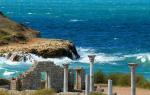
(Spanish Mar Caribe; English Caribbean Sea) - one of the most beautiful tropical seas, included in the Atlantic Ocean basin. The marginal semi-enclosed sea, from the south and west bounded by the Central and South America, from the east and north - the Antilles (thanks to which the sea has a second name - Antilles).
In the northwest, the sea through the Yucatan Channel (Spanish Yucatán Channel) communicates with the Gulf of Mexico; through many inter-island straits - from Atlantic Ocean; and in the south-west, through an artificially constructed 80-kilometer waterway (Panama Canal) - with the waters of the Pacific Ocean. The region where the Caribbean Sea stretches is known as the "Caribbean". The coasts of the following countries are washed by sea waters: in the south - and Panama; in the west - Costa Rica, Nicaragua, Honduras, Guatemala, Belize and (Mexican peninsula); in the north - Haiti, Cuba, Puerto Rico and Jamaica; in the east - the countries of the Lesser Antilles. The area of the sea surface is about 2,753 thousand km ², the average volume of water is about 6,860 thousand km ³.
Photo gallery not opening? Go to the site version.
The sea is considered very deep: its average depth is 2.5 thousand meters, the maximum is 7.7 thousand meters ("Cayman depression"). Sea water color: from turquoise (bluish green) to deep green.
The Caribbean has a huge economic and strategic importance, first of all, as the shortest sea route connecting American ports with the ports of the Atlantic and Pacific Oceans through one of the largest construction projects carried out by mankind (Spanish del Canal de Panama). The most important ports on the Caribbean Sea are: and (Venezuela); (Colombia); Lemon (Costa Rica); Santo Domingo ( Dominican Republic); Colon (Panama); Santiago de Cuba (Cuba), etc.
Climate
 The climate in the Caribbean is influenced by warm ocean currents and solar activity in this tropical belt. The average annual temperature of the surface layers of sea water is + 26 ° С. The Caribbean Sea receives the waters of many rivers, among which it should be noted (Spanish Madalena), Atrato (Spanish Atrato), Belen (Spanish Belém), Dike (Spanish Dique), Cricamola (Spanish Kramola), etc.
The main nuisance that often disturbs the idyll of these fabulous places is devastating storms. The Caribbean Sea is considered to be the site with the highest number of hurricane storms in the Western Hemisphere.
The violent hurricanes pose a major challenge to the island and coastal community. Hurricanes also cause great damage to numerous coral formations - atolls, reefs, coastal borders of islands. The northern Caribbean experiences an average of 8-9 tropical hurricanes per year from June to November.
Cradle of Pirates (Caribbean)
The sea got its name from a tribe of Caribbean Indians who lived on its warm coast in the pre-Columbian era. The sea has become famous for its amazing beauty of coral reefs, frequent tropical cyclones, which are accompanied by crushing hurricanes, and pirates, who have long chosen it as a field for their "fishing activities".
The coastline of the sea along its entire length is extremely indented: there are numerous lagoons, bays, coves, capes. The coastal soil is sandy, sandy-silty or rocky in places.
The coast in many places is covered with coral, amazing white sand.
Among large bays it should be noted Honduran (Spanish Golfo de Honduras), (Spanish Golfo de Venezuela), Mosquitoes (Spanish Golfo de los Mosquitos), Ana Maria (Spanish Golfo Anna Maria), Batabano (Spanish Golfo de Batabano), Gonav (Spanish Golfo de Gonave).

The Caribbean Sea is very rich in islands... General group Caribbean islands united under the name "Antilles archipelago" (Spanish Antillas archipielago) or "West Indies" (Spanish West India archipielago). The archipelago is subdivided into island groups: the Greater Antilles and Lesser Antilles (the Netherlands Islands), and the Bahamas (Spanish Bahamas).
The Greater Antilles, which are mainly of continental origin, located in the northern part of the sea, include such large islands like Cuba, Haiti, Jamaica and Puerto Rico. Small Antilles(subdivided into Windward and Leeward, depending on their location to the northeastern trade winds) are mainly of volcanic or coral origin.
Among the multitude small islands of this group, the following can be distinguished: the famous Bahamas; distinctive Turks and Caicos; Virgin Islands divided between the US and the UK; exotic Antigua and Barbuda; open to the ubiquitous Guadeloupe; the island of Martinique (FR. Martinique), known as the birthplace of Josephine Beauharnais (FR. Joséphine de Beauharnais), the first wife of Napoleon I; as well as Grenada, Barbados, Trinidad and Tobago; and finally, Dominica, the largest of the Windward Islands. Perhaps it is necessary to mention the island of Curacao, which "gave" its name to the popular liquor.
Tourist paradise

The extraordinary popularity of the Caribbean among tourists is easily explained: the warm sea all year round, fabulous beauty nature, a decent level of service, a wide selection of hotels (for every taste and budget) and a huge "menu" of all kinds of entertainment: interesting excursions, an abundance of historical and natural attractions, water and "land" sports, restaurants, discos, nightclubs.
A distinctive feature of the Caribbean region is considered to be a large selection of varied leisure options: each state has its own "specialization".
For example, in Barbados, English national traditions are firmly rooted in life; rest here is mostly measured and calm.
Known as the "Spice Island", Grenada is home to museums, botanical gardens, historic sites and chic white beaches.
Magnificent hotels the highest level, excellent diving conditions and the famous SPA-centers of Turks and Caicos attract the attention of respectable visitors.
Saint Lucia bears the proud title "Garden Island", being one of the the most beautiful islands The Caribbean. As if to counterbalance it, the desert island of Aruba is located in the Caribbean Sea, with luxurious hotels and enchanting nightlife.
The Bahamas offers tourists all kinds of accommodation options, from secluded small hotels to bustling hotel complexes.
And in Curacao, it's simply impossible not to stop by one of the many bars for a delicious blue drink!
Bottom relief
The bottom relief of the sea is characterized by unevenness - numerous uplifts and depressions, underwater ridges, the bottom is conditionally divided into 5 main basins: Grenada (4120 m), Colombian (4532 m), Venezuelan (5420 m), Yucatan (5055 m) and Bartlett, with deep-water Cayman trench (7090 m, this is the world's deepest underwater volcanic fault). The Caribbean is considered seismically active; underwater earthquakes are frequent here, often causing tsunamis.

The deep-sea seabed is covered with calcareous foraminiferal silts and clays.
Flora and fauna
Vegetable and animal world The Caribbean is unusually rich and varied. Extensive coral structures are typical tropical coral communities of living organisms. Huge variety and amazing beauty of forms water world attract here and amaze with their splendor connoisseurs of underwater landscapes and the most sophisticated divers from all over the world. Although the local flora is not distinguished in quantitative terms, it is characterized by a rich species composition. In the Caribbean Sea, you can find entire underwater fields of macroalgae. In shallow areas, vegetation is mainly concentrated in coral reef zones. There are such algae as tortoiseshell thalassia (lat. Thalassia lestudinum), cymodocea algae (lat. Cymodoceaceae), sea ruppia (lat. Ruppia maritima). Chlorophyll algae grow in deep-water areas. There are dozens of different species of macroalgae in the Caribbean.
Phytoalgae are very poorly represented here, however, as in all tropical seas.
The fauna of the sea is richer and more diverse than the flora. Various fish, marine mammals and all kinds of benthic animals live here.
The bottom Caribbean fauna is represented by numerous sea snakes, worms, molluscs (gastropods, cephalopods, bivalves, etc.), various crustaceans (crustaceans, crabs, lobsters, etc.) and echinoderms (hedgehogs, starfish). Cavities are composed of a rich spectrum of coral polyps (including reef-forming ones) and all kinds of jellyfish.
 The Caribbean Sea is home to sea turtles: here you can find the green turtle (soup), loggerhead turtle (loggerhead), byssa or real caretta, as well as the Atlantic ridley, the species of the smallest and fastest growing sea turtles. When famous at the beginning of the 16th century. crossed the Caribbean Sea in the area of the present Cayman Islands, the way to his ships was literally blocked by an endless herd of green turtles. Struck by the abundance of these sea animals, Columbus named the group of islands he discovered "Las Tortugas" (Spanish Las Tortugas - "turtles").
For centuries, turtles have provided food for travelers, sailors, pirates and whalers at Las Tortugas. But this beautiful name, unfortunately, did not take root, just as the once countless herds of turtle did not survive. As a result of thoughtless human activity (uncontrolled long-term fishing, ruin of turtle egg-laying, ruthless pollution of the sea), where in the old days sailing ships could hardly make their way through a dense barrier of teeming turtle shells, now it is not easy to meet even one individual.
Marine mammals have also settled in the warm, gentle waters of the Caribbean. Large cetaceans (sperm whales, humpback whales) and several dozen species of smaller dolphins can be found here. Pinnipeds are also found here, which are mainly represented by crack-toothed (lat. Solenodontidae) - small mammals that live on some islands. In ancient times, many monk seals lived in the Caribbean, today this species is extinct.
The Caribbean fauna is endlessly diverse! Once it did not exist, just a few millennia ago the water connection of the world's great oceans - the Pacific and the Atlantic - was disrupted, so the diversity of the Caribbean fauna is explained by the presence of many Pacific species of animals here.
Almost 500 different species of fish live here, ranging from small schooling and bottom-dwelling representatives of the fish community (moray eels, barracudas, flounders, gobies, stingrays, flying fish) and ending with large fish species (sharks, marlin, swordfish, tuna, etc.).
The objects of fishing in the sea are mainly sardines, tuna, lobsters; objects of sport fishing - sharks, marlins, large barracudas and swordfish.
 Numerous sharks of the Caribbean Sea are represented by gray sharks (including reef sharks, bovine sharks, silk sharks) and various benthic species (nannies, six-gill, squatine, etc.). Tiger and even white sharks, which are very rare, are also found in coastal waters. In the open waters of the sea, you can find hammerhead, blue, whale and long-finned sharks. By the way, the largest of the sharks - the whale never attacks humans, it feeds on plankton and small fish, filtering the water through thousands of sharp, small teeth. The most dangerous for humans is considered White shark
As soon as you go to Cancun Beach, the bright turquoise ocean opens up to your eyes. Therefore, I would like to separately describe how beautiful the Caribbean Sea is in Cancun. It seems to me only nana Maldives sea water can be so bright. You stand on the shore and cannot believe that such a thing is possible in nature!
Cancun beach. Photos from our balcony at the hotel
 Another view from the balcony

Beach in Cancun
Cancun Beach
The color of the Caribbean sea conquers everyone! And then, I think, people become more picky about water if they fly to, for example, Bali on their next trip. Sand, entry into the sea, depth, purity and color of the water are all at the highest level.


Waves
The waves in Cancun on the Caribbean coast are not small, but the beauty that a person sees in front of him overshadows these waves and you jump joyfully with happiness. Swimming will not work, but jumping in the waves near the shore is also a pleasure. Perhaps this is a seasonal phenomenon.

Photo: Cancun Beach

A glass for those who travel to Mexico to Cancun

Seaweed on Cancun Beach
Seaweed
There are algae, almost all over the beach, which do not have time to quickly remove. At first it was embarrassing and not very pleasant, but on the second day you accept it and no longer pay attention. Our hotel Oasis Cancun is perfectly clean around the perimeter of the beach, and the cleaning staff work tirelessly. In the morning, seaweed is collected on the tractor.

Purity
And maybe the contingent of people who come to Mexico is somewhat different, so in Cancun you will not see bags, bottles, packages from chips floating and rotting in water, or other dirt, this is not here. Our impressions of this resort are detailed in the article
"Sea, sea ... The world is bottomless!" - these words from a once popular song excite our imagination with romantic pictures of seascapes with blue distances, blue skies and turquoise waves. Somewhere in our souls our distant warm sea begins to rustle, echoing the rustling waves in summer sea fantasies ...
According to the International Geographical Bureau, there are 4 oceans and 54 seas on Earth, which together form the World Ocean, which makes up two-thirds of the surface of the entire globe.

If seawater is collected in the palm of your hand, it will turn out to be transparent, completely devoid of any color. And only in the sea or ocean does it acquire its unique shade.
The color of sea water in the World Ocean is far from uniform, and in different parts of the Earth it is different, that is, each sea has a unique color shade inherent only to it.

For the first time, a device for determining the color of reservoirs was invented at the end of the 19th century by the Swiss geographer Forel, who was studying lakes. The device was somewhat inconvenient for working with sea water.
The famous German oceanographer Ole developed a color scale for water, consisting of a set of twenty-two sealed glass test tubes with samples of solutions of different shades, from light aquamarine to brownish green. Ole modified the device, improved it, and in the given time with this device, you can determine the color of sea water.
The color of the sea water changes periodically, and this depends on many factors, primarily on lighting, depth, transparency, color of the seabed, the presence of gases and the quantitative density of microorganisms that inhabit the sea, as well as on such phenomena as the glow and bloom of the sea.

Caribbean sea
In the distance, the sea in its color shade is close to the color of the sky. In cloudy weather, it is gray, in clear weather it is blue. When the sun sets, the bright blue sea takes on a golden hue. During rough seas, the sea appears whitish.

Scientists who study the depths of the sea claim that many seas got their name from the color of the water. They believe that in warm seas in the tropical zone, the color of the water is dark blue, and even blue, in the shelf seas, it is greenish, and in the muddy coastal seas it has a yellowish tint.
Have you ever wondered why most seas are named by color? For example, Yellow, Black, Red, Blue ..?

Why is the White Sea called white, Black - black, Red - red, and Yellow - yellow?
White Sea- the sacred sea of the North, it is fraught with a lot unsolved mysteries... The White Sea got its name, possibly from the color white snow and ice that cover it in winter. But there is one more assumption, which is that the name "White" sea received from the religious meaning of the sphere, that is, the heavenly. Indeed, in semantics, white is a heavenly, divine color. There is a hypothesis that the White Sea and its coast are located on the territory of the once flourishing mystical civilization - Hyperborea.

White Sea. Solovki.
Black Sea got its name because in cloudy weather the surface of the sea darkens under black clouds. The Turkic nomads, who noticed this, gave him a name - "Kara-Deniz".
There is another plausible assumption about the origin of the name of the Black Sea. It has been known for a long time that all objects that have been in its mysterious depths turn black. And this happens because at a depth of more than 200 meters, sea water is saturated with hydrogen sulfide, which easily forms black salts.

Black Sea.
Red sea has a red color due to brown microscopic algae that periodically develop in it. But there is also another version regarding the name of the Red Sea. They say that in ancient times sailors gave the sea the name "Red" because of the color of the rocks that surround it.
Exists ancient legend, referring to biblical events, which tells about the difficult transition of Jews from Egypt to Israel through the Red Sea. Moses, who was leading the Jewish people, ordered By God's name make way for sea waters. And before their eyes it opened deep bottom seas with rocks and mountain ranges, with gorges and depressions, during the passage through which a lot of people died, which was the reason for the name of the Red Sea.
The Red Sea, located between Asia and Africa, is where the desert meets the ocean and is one of the most exotic places on our planet.Moreover, the Red Sea is one of the most transparent and salty seas. Its crystal purity is explained by the fact that not a single river flows into it, which could bring silt and sand with it and, thereby, muddy the sea waters. And although the sea has the name Red, but its waters have a beautiful azure color.

Red sea
Yellow Sea- a semi-enclosed marginal sea of the Pacific Ocean off the east coast of Asia to the west of the Korean Peninsula. The name is given for the color of the water caused by the sediment of Chinese rivers and dust storms. In spring, yellow dust storms are so severe that ships have to stop moving.
The Yellow Sea forms the West Korean, Liaodong and Bohai bays. Primarily coastline calm, composed of alluvial deposits. There are convenient harbors on the coast of the Liaodong and Shandong peninsulas. The Yellow Sea itself is shallow, especially in the western part, where the Yellow Sea flows into it, carrying out a huge amount of silt, eroded loess (hence the name: Yellow River - Yellow River, Huanghai - Yellow Sea).

Yellow Sea
Which seas have the greenest water color?
There is amazing on Earth beautiful seas with bewitching eyes fabulous shades. These sea "beauties" include Sargasso Sea.
The Sargasso Sea has a bright greenish hue due to the accumulation of green algae on its surface, which form entire islands, roads, and even fields. And the sailors, who first appeared in this area of the ocean, mistakenly took it for land.

Sargasso Sea
One of the brightest tropical seas is Caribbean sea... Its water shines from deep turquoise to bright emerald hues.

Caribbean Sea. St. Martin's Island
Azov sea also has a greenish tint, especially during the plankton season. And in the season of storms, the sea takes on a color from yellow-green to yellow-brown due to changes in the transparency of the water. The sea begins to become cloudy, because periodically there is a stirring up of bottom silt and an increase in the river flow of turbid waters.

Azov sea
And if you try to answer the question which sea is the bluest, you can hardly come to one single true answer. After all, each sea has its own unique color from the blue range with unique shades of turquoise, aquamarine or emerald.
The bluest sea is the sea that lives in our joyful memories or sweet dreams of beauty. And dreams will certainly come true ...

The very thing ...
The deepest sea in the world is the Philippine Sea, with an area of more than 5.7 million km2. The greatest depth here reaches 10265 m.And the shallowest is the Yellow Sea, where the depth does not exceed 100 m.
The largest surface is occupied by the waters of the Sargasso Sea - about 7 million km2. The White Sea is the smallest among the ocean seas. The area of its water surface is only 90 thousand km2.
The Red Sea is the warmest and saltiest sea on the planet. The strongest evaporation of seawater occurs from its surface in comparison with other seas. It is curious that not a single river flows into this open sea. Maybe for this reason, the Red Sea holds the lead among the most polluted seas in the world.
The record for the transparency of sea water on the planet is marked off the coast of Antarctica, in the Weddell Sea. Here the water is the purest, almost like distilled water. A white object dropped to a depth of 79 m remains visible to the naked eye.Among the seas that wash other parts of the world, there is the clearest water in the Mediterranean. The contours of the white object differ in it at a depth of 53 m. Extremely transparent water in the oceanic expanses of the planet was discovered in 1987 in the eastern part of the Guiana Basin in the Atlantic at a depth of 4 km.
And the saltiest sea water - at a depth of 150 m in the Gulf of Mexico off the coast American state Louisiana. In this pit, 24 km by 15 km in area, its salinity is about 10 times higher than the average salinity of seawater.
The highest gold content in sea water recorded in the Baltic Sea. It contains 3 times more precious metal than the waters of the North Sea, and 5 times more than the Black Sea. The average gold content in seawater is 0.000004 g / t.
The largest model of a part of the planet's aquatic environment was built in 1971 in Japan. He reproduces in detail the Inland Sea of Japan. The dimensions of the model are 230 m by 100 m. The model serves as a testing ground for the implementation of the planned ocean development projects and various environmental protection measures.
In ancient times, the Baltic Sea was called Amber because of the abundance of amber in it.
Researchers of the Caspian Sea note that this sea had the largest number of names - about 70 names: Avar, Eastern, Chirkanskoe, Khvalynskoe and others, which reflected the history and geography of its coasts. The name of the Caspian Sea is associated with the name of the Caspian tribe who lived on its shores in ancient times.

Interesting:
Poets, artists, novelists sang the ninth wave as the largest among the raging waves. But in reality, the ninth wave does not exist. It is easy to verify this by counting the number of intermediate waves between the two largest waves from the side of the ship or from the shore. Any wave can be the biggest wave. But where did the name "ninth wave" come from? It arose in ancient times from the mythological concept of nine as a sacred number.