Where is the Caspian Sea lake. Seas of Russia - Caspian Sea
The Caspian Sea is located on the border of Europe and Asia and is surrounded by the territories of five states: Russia, Azerbaijan, Iran, Turkmenistan and Kazakhstan. Despite the name, the Caspian is the largest lake on the planet (its area is 371,000 km2), but the bottom, formed by the oceanic crust, and salt water, together with its large size, give reason to consider it as a sea. A large number of rivers flow into the Caspian Sea, for example, such large ones as the Volga, Terek, Ural, Kura and others.
Relief and depth of the Caspian Sea
According to the bottom relief, the Caspian Sea is divided into three parts: southern (the largest and deepest), middle and northern.
In the northern part, the depth of the sea is the smallest: on average, it ranges from four to eight meters, and the maximum depth here reaches 25 m. The northern part of the Caspian Sea is limited by the Mangyshlak Peninsula and occupies 25% of the entire area of the reservoir.

The middle part of the Caspian Sea is deeper. Here the average depth is already equal to 190 m, while the maximum is 788 meters. The area of the middle Caspian Sea is 36% of the total, and the volume of water is 33% of the total volume of the sea. It is separated from the southern part by the Absheron Peninsula in Azerbaijan.
The deepest and largest part of the Caspian Sea is the southern one. It occupies 39% of the total area, and its share of the total water volume is 66%. Here is the South Caspian depression, in which the deepest point of the sea is located - 1025 m.
Islands, peninsulas and bays of the Caspian Sea
In total, there are about 50 islands in the Caspian Sea, almost all of them are uninhabited. Due to the shallower depth of the northern part of the sea, most of the islands are located there, including the Baku archipelago belonging to Azerbaijan, the Seal Islands in Kazakhstan, as well as many Russian islands off the coast of the Astrakhan region and Dagestan.
Among the peninsulas of the Caspian Sea, the largest are Mangyshlak (Mangistau) in Kazakhstan and Absheron in Azerbaijan, where such large cities as the capital of the country Baku and Sumgait are located.
Gulf of Kara-Bogaz-Gol Caspian Sea

The coastline of the sea is strongly indented, and there are many bays on it, for example, Kizlyar, Mangyshlak, Dead Kultuk and others. The Kara-Bogaz-Gol Bay deserves a special mention, which is actually a separate lake connected to the Caspian by a narrow strait, due to which a separate ecosystem and higher water salinity are preserved in it.
Fishing in the Caspian Sea
The Caspian Sea has long attracted the inhabitants of its shores with its fish resources. Here, about 90% of all world sturgeon production is caught, as well as fish such as carp, bream, sprat.

Caspian Sea video
In addition to fish, the Caspian is extremely rich in oil and gas, the total reserves of which are about 18-20 million tons. Salt, limestone, sand and clay are also mined here.
If you liked this material, share it with your friends on social networks. Thanks!
The Caspian Sea is one of the largest salt water bodies on Earth, located at the junction of Europe and Asia. Its total area is about 370 thousand square meters. km. The reservoir receives over 100 water streams. The largest rivers flowing into the Volga, Ural, Emba, Terek, Sulak, Samur, Kura, Atrek, Sefidrud.
Volga river - the pearl of Russia
The Volga is a river flowing in the territory of the Russian Federation, partially crosses Kazakhstan. Belongs to the category of the largest and longest rivers on Earth. The total length of the Volga is over 3,500 km. The river originates in the Volgoverkhovye village of the Tver region, located on After that, it continues its movement through the territory of the Russian Federation.
It flows into the Caspian Sea, but does not have a direct outlet to the World Ocean, therefore it is referred to as internal flows. The watercourse receives about 200 tributaries and has more than 150 thousand drains. Today, reservoirs have been built on the river, which allow regulating the flow, due to which fluctuations in the water level have been sharply reduced.
The fishing of the river is varied. Melon growing prevails in the Volga region: the fields are occupied by grain and industrial crops; table salt is mined. Oil and gas fields have been discovered in the Urals region. The Volga is the largest river flowing into the Caspian Sea, therefore it is of great importance for Russia. The main transport facility that allows you to cross this stream is the longest in Russia.
Ural - a river in Eastern Europe
The Ural, like the Volga River, flows on the territory of two states - Kazakhstan and the Russian Federation. The historical name is Yaik. It originates in Bashkortostan at the top of the Uraltau ridge. The Ural River flows into the Caspian Sea. Its pool is the sixth largest in the Russian Federation, and its area is more than 230 sq. km. An interesting fact: the Ural River, contrary to popular belief, belongs to the inner European river, and only its upper course in Russia belongs to Asia.
The mouth of the watercourse is gradually shallowing. At this point, the river is divided into several branches. This feature is typical for the entire length of the channel. During floods, one can observe how the Ural overflows its banks, in principle, like many other rivers in Russia flowing into the Caspian Sea. This is especially observed in places with a gentle coastline. Flooding occurs at a distance of up to 7 meters from the channel.

Emba - the river of Kazakhstan
Emba is a river flowing in the territory of the Republic of Kazakhstan. The name comes from the Turkmen language, literally translates as "the valley of food". The river basin with an area of 40 thousand square meters. km. The river begins its journey in the Mugodzhary mountains and, flowing along, is lost among the marshes. Asking which rivers flow into the Caspian Sea, we can say that in full-flowing years the Emba reaches its basin.
Natural resources such as oil and gas are being extracted along the river's coastline. The issue of passing the border between Europe and Asia along the Emba watercourse, as in the case of the river. Ural, an open topic today. The reason for this is a natural factor: the mountains of the Ural ridge, which are the main reference point for drawing borders, disappear, forming a homogeneous terrain.
Terek - mountain water stream
Terek is a river of the North Caucasus. The name is literally translated from Turkic as "poplar". The Terek flows out of the glacier of Mount Zilga-Khokh, located in the Trusov Gorge of the Caucasus Range. passes through the lands of many states: North Ossetia, Georgia, Stavropol Territory, Kabardino-Balkaria, Dagestan and the Chechen Republic. It flows into the Caspian Sea and the Arkhangelsk Gulf. The length of the river is just over 600 km, the basin is about 43 thousand square meters. km. An interesting fact is that every 60-70 years the stream forms a new transit arm, while the old one loses its strength and disappears.
The Terek, like other rivers flowing into the Caspian Sea, is widely used to meet human economic needs: it is used to irrigate arid areas of adjacent lowlands. Also, there are several hydroelectric power plants on the water stream, the total average annual output of which is more than 200 million kWh. In the near future, it is planned to launch new additional stations.

Sulak - water stream of Dagestan
Sulak is a river that connects the Avar Koisu and the Andean Koisu streams. It flows on the territory of Dagestan. It begins in the Main Sulak Canyon and ends its journey in the waters of the Caspian Sea. The main purpose of the river is water supply to two cities of Dagestan - Makhachkala and Kaspiysk. Also, several hydroelectric power plants are already located on the river, it is planned to launch new ones to increase the generated capacity.
Samur - the pearl of South Dagestan
Samur is the second largest river in Dagestan. Literally the name is translated from Indo-Aryan as "abundance of water". It begins at the foot of Mount Guton; it flows into the waters of the Caspian by two branches - Samur and Maly Samur. The total length of the river is just over 200 km.
All rivers flowing into the Caspian Sea are of great importance for the territories through which they flow. Samur is no exception. The main direction of the use of the river is irrigation of lands and provision of residents of nearby cities with drinking water. It is because of this that the hydroelectric complex and a number of the Samur-Divichinsky canal were built.
At the beginning of the 20th century (2010), Russia and Azerbaijan signed an interstate agreement requiring both sides to efficiently use the resources of the Samur River. The same agreement introduced territorial changes between these countries. The border of the two states was moved to the middle of the hydroelectric complex.

Kura is the largest river in Transcaucasia
Asking which rivers flow into the Caspian Sea, I would like to describe the Kura stream. It flows on the ground of three states at once: Turkey, Georgia, Azerbaijan. The length of the stream is more than 1000 km, the total area of the basin is about 200 thousand square meters. km. Part of the basin is located on the territory of Armenia and Iran. The source of the river is in the Turkish province of Kars, and flows into the waters of the Caspian Sea. The path of the river is thorny, laid among hollows and gorges, for which it got its name, which in translation from the Mingrelian language means "gnaw", that is, the Kura is a river, "gnawing" itself even among the mountains.
There are many cities on it, such as Borjomi, Tbilisi, Mtskheta and others. It plays an important role in meeting the economic needs of the inhabitants of these cities: hydroelectric power plants are located, and the Mingechevir reservoir created on the river is one of the main reserves of fresh water for Azerbaijan. Unfortunately, the ecological state of the stream leaves much to be desired: the level of harmful substances is several times higher than the permissible limits.

Features of the Atrek River
Atrek is a river located in Iran and Turkmenistan. It originates in the Turkmen-Kharasan mountains. Due to the active use in economic needs for irrigating land, the river became shallow. For this reason, it reaches the Caspian Sea only during the flood period.
Sefidrud - a high-water river of the Caspian
Sefidrud is a large river of the Iranian state. Initially it was formed by the confluence of two water streams - Kyzyluzen and Shahrud. Now it flows out of the Shabanau reservoir and flows into the depths of the Caspian. The total length of the river is over 700 km. The creation of a reservoir has become a necessity. It made it possible to minimize the risks of flooding, thereby protecting the cities located in the river delta. Water is used for irrigation of lands with a total area of more than 200 thousand hectares of land.

As can be seen from the presented material, the Earth's water resources are in an unsatisfactory state. The rivers flowing into the Caspian Sea are actively used by man to satisfy his needs. And this has a detrimental effect on their condition: the watercourses are depleted and polluted. That is why scientists from all over the world are sounding the alarm and conducting active propaganda, calling for saving and conserving water on Earth.
The Caspian Sea is the largest closed body of water on the planet Earth, located on the continent of Eurasia - in the border territories of the states of Russia, Kazakhstan, Turkmenistan, Iran and Azerbaijan. In fact, it is a giant lake left after the disappearance of the ancient Tethys ocean. Nevertheless, there is every reason to consider it as an independent sea (this is indicated by salinity, a large area and a decent depth, a bottom from the oceanic crust and other signs). In terms of maximum depth, it is the third among closed bodies of water - after lakes Baikal and Tanganyika. In the northern part of the Caspian Sea (a few kilometers from the northern coast - parallel to it) there is a geographical border between Europe and Asia.
Toponymy
- Other names: throughout the history of mankind, the Caspian Sea had about 70 different names among different peoples. The most famous of them: Khvalynskoe or Khvalisskoe (took place during the time of Ancient Rus, arose by the name of the people praises who lived in the Northern Caspian Sea and traded with the Russians), Girkanskoe or Dzhurdzhanskoe (derived from the alternative names of the city of Gorgan, located in Iran), Khazar, Abeskunskoe (by the name of the island and the city in the Kura delta - now flooded), Saraisk, Derbent, Sihai ...
- Origin of name: according to one of the hypotheses, the Caspian Sea received its modern and most ancient name from a tribe of nomadic horse breeders Kaspiev who lived in the 1st millennium BC on the southwestern coast.
Morphometry
- Drainage area: 3,626,000 km².
- Mirror area: 371,000 km².
- Coastline length: 7,000 km
- Volume: 78 200 km³.
- Average depth: 208 m.
- Maximum depth: 1,025 m.
Hydrology
- The presence of a constant flow: no, drainless.
- Inflows:, Ural, Emba, Atrek, Gorgan, Heraz, Sefidrud, Astarchay, Kura, Pirsagat, Kusarchay, Samur, Rubas, Darvagchay, Uluchay, Shuraozen, Sulak, Terek, Kuma.
- Bottom: very diverse. At shallow depths, sandy soil with an admixture of shells is common, in deep-water places it is silty. Pebble and rocky places can be found in the coastal strip (especially where mountain ranges adjoin the sea). In the estuarine areas, the underwater soil consists of river sediments. The Kara-Bogaz-Gol bay is notable for the fact that its bottom is a thick layer of mineral salts.
Chemical composition
- Water: brackish.
- Salinity: 13 g / l.
- Transparency: 15 m.
Geography

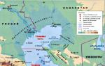
Rice. 1. Map of the Caspian Sea Basin.
- Coordinates: 41 ° 59′02 ″ s. sh., 51 ° 03'52 ″ in. etc.
- Height above sea level:-28 m.
- Coastal landscape: due to the fact that the coastline of the Caspian Sea is very long, and it itself is located in different geographic zones, the coastal landscape is diverse. In the northern part of the reservoir, the shores are low, swampy, in places of the deltas of large rivers cut by numerous channels. The eastern shores are mostly limestone - desert or semi-desert. The western and southern shores are adjacent to mountain ranges. The most indented coastline is observed in the west - in the area of the Apsheron Peninsula, as well as in the east - in the area of the Kazakh and Kara-Bogaz-Gol bays.
- Settlements on the banks:
- Russia: Astrakhan, Derbent, Kaspiysk, Makhachkala, Olya.
- Kazakhstan: Aktau, Atyrau, Kuryk, Sogandyk, Bautino.
- Turkmenistan: Ekerem, Karabogaz, Turkmenbashi, Khazar.
- Iran: Astara, Balboser, Bender-Torkemen, Bender-Anzali, Neka, Chalus.
- Azerbaijan: Alat, Astara, Baku, Dubendi, Lankaran, Sangachaly, Sumgayit.
Interactive map
Ecology
The ecological situation in the Caspian Sea is far from ideal. Practically all large rivers flowing into it are polluted by wastewater from industrial enterprises located upstream. This could not but affect the presence of pollutants in the waters and bottom sediments of the Caspian - over the past half century, their concentration has increased markedly, and the content of some heavy metals has already exceeded the permissible limits.
In addition, the waters of the Caspian Sea are constantly polluted by domestic wastewater from coastal cities, as well as during oil production on the continental shelf, and during its transportation.
Fishing in the Caspian Sea
- Fish species:
- Artificial settlement: not all of the above fish species in the Caspian Sea are indigenous. About 4 dozen species came by accident (for example, through canals from the Black and Baltic Seas), or were deliberately inhabited by humans. An example is mullet. Three Black Sea species of these fish - striped mullet, ostronos and singil - were released in the first half of the 20th century. Loban didn’t take root, but ostronos with singil have successfully acclimatized, and by now they have settled practically throughout the entire water area of the Caspian, having formed several commercial herds. At the same time, the fish feed faster than in the Black Sea, and reach larger sizes. In the second half of the last century (since 1962), attempts were also made to settle in the Caspian Sea such Far Eastern salmon fishes as pink salmon and chum salmon. In total, several billion fry of these fish were released into the sea for 5 years. The pink salmon did not survive in the new habitat, the chum salmon, on the contrary, successfully took root and even began to spawn in the rivers flowing into the sea. However, she could not reproduce in sufficient numbers and gradually disappeared. So far, there are no favorable conditions for its full-fledged natural reproduction (there are very few places where spawning and development of fry could successfully occur). To ensure them, reclamation of rivers is needed, otherwise, without human help (artificial sampling of eggs and its incubation), the fish will not be able to maintain their numbers.


Fishing spots
In fact, fishing is possible anywhere along the coast of the Caspian Sea, which can be reached by land or water. What species of fish will be caught at the same time depends on local conditions, but to a greater extent on whether rivers flow here. As a rule, in places where estuaries and deltas are located (especially large watercourses), the water in the sea is greatly desalinated, therefore freshwater fish (carp, catfish, bream, etc.) usually prevail in catches, and species characteristic of flowing rivers (barbel, shemaya). Of the marine species in desalinated areas, those for which salinity does not matter (mullet, some of the gobies) are caught. In certain periods of the year, semi-anadromous and anadromous species can be found here, feeding in the sea, and spawning in rivers (sturgeon, some of herring, Caspian salmon). In places where there are no rivers flowing into it, freshwater species are found in slightly smaller numbers, but at the same time marine fish appear, usually avoiding desalinated areas (for example, sea pike perch). Away from the coast, fish that prefer salt water and deep-sea species are caught.
Conventionally, there are 9 places or areas that are interesting in terms of fishing:
- North Shore (RF)- this site is located on the northern coast of the Russian Federation (from the Volga delta to the Kizlyar Bay). Its main features are insignificant salinity of water (the lowest in the Caspian Sea), shallow depth, the presence of multiple shoals, islands, highly developed aquatic vegetation. In addition to the Volga delta with its numerous channels, bays and eriks, it also includes the near-estuarine seashore, called the Caspian peals. These places are popular with Russian fishermen, and for good reason: the conditions for fish are very favorable here, and there is also a good food base. The ichthyofauna in these parts may not be distinguished by the richness of species, but it is distinguished by its multiplicity, and its individual representatives reach very considerable sizes. Typically, the main catches are freshwater fish typical for the Volga basin. Most often caught: perch, pike perch, roach (more precisely - its varieties, called roach and ram), rudd, asp, sabrefish, bream, goldfish, carp, catfish, pike. Bersh, silver bream, white-eyed, blue bream are somewhat less common. Representatives of sturgeon (sturgeon, stellate sturgeon, beluga, etc.), salmon (nelma, brown trout - Caspian salmon) are also found in these places, but fishing is prohibited.
- Northwest coast (RF)- this section covers the western coast of the Russian Federation (from the Kizlyar Bay to Makhachkala). The rivers Kuma, Terek and Sulak flow here - they carry their waters both along natural channels and artificial canals. There are bays in this area, some of which are quite large (Kizlyarsky, Agrakhansky). The sea in these places is shallow. Freshwater fish predominate in the catches: pike, perch, carp, catfish, rudd, bream, barbel, etc.
- West Bank (RF)- from Makhachkala to the border of the Russian Federation with Azerbaijan. A site where mountain ranges adjoin the sea. The salinity of the water here is slightly higher than in previous places, therefore, in the catches of fishermen, marine species are more common (sea pike perch, mullet, herring). However, freshwater fish are by no means uncommon.
- West Bank (Azerbaijan)- from the border of the Russian Federation with Azerbaijan along the Absheron Peninsula. Continuation of the site, where mountain ranges adjoin the sea. Fishing here is even more like a typical sea one, thanks to fish such as ostronos and singil (mullet) and several species of gobies, which are also caught here. In addition to them, there are kutum, herring, and some typically freshwater species, for example, the carp.
- Southwest coast (Azerbaijan)- from the Absheron Peninsula to the border of Azerbaijan with Iran. Most of this site is occupied by the Kura River delta. The same fish species that were listed in the previous paragraph are caught here, but freshwater fish are more often caught.
- North coast (Kazakhstan)- this section covers the northern coast of Kazakhstan. The Ural delta and the Akzhaiyk state reserve are located here, so fishing directly in the river delta and in some adjacent water area is prohibited. Fishing is possible only outside the reserve - upstream of the delta, or in the sea - at some distance from it. Fishing near the Ural delta has much in common with fishing at the confluence of the Volga - almost the same species of fish are found here.
- North-east coast (Kazakhstan)- from the mouth of the Emba to Cape Tyub-Karagan. Unlike the northern part of the sea, where the water is greatly diluted by the large rivers flowing into it, its salinity somewhat increases here, so those fish species appear that avoid freshened areas, for example, sea pike perch, which is caught in the Dead Kultuk Bay. Other representatives of the marine fauna are also often found in the catches.
- East coast (Kazakhstan, Turkmenistan)- from Cape Tyub-Karagan to the border of Turkmenistan and Iran. Differs in almost complete absence of flowing rivers. The salinity of the water is at its maximum here. Of the fish in these places, marine species predominate, the main catch is mullet, sea pike perch and gobies.
- South Coast (Iran)- covers the southern coast of the Caspian. Along the entire length of this section, the Elburs mountain range adjoins the sea. Many rivers flow here, most of which are represented by small streams, there are also several medium and one large river. Among fish, in addition to marine species, there are also some freshwater, as well as semi-anadromous and anadromous species, for example, sturgeon.
Fishing features
The most popular and catchy amateur tackle, which is used on the Caspian coast, is a heavy spinning rod converted into a "sea donkey". Usually it is equipped with a strong reel, on which a rather thick line (0.3 mm and more) is wound. The thickness of the fishing line is determined not so much by the size of the fish as by the mass of a rather heavy sinker, which is necessary for ultra-long casting (in the Caspian it is generally believed that the further from the coast the casting point is, the better). After the sinker, there is a thinner line - with several leads. Shrimps and amphipods that live in coastal thickets of seaweed are used as a bait - if you intend to fish for sea fish, or an ordinary bait like a worm, May beetle larvae and others - if freshwater species are found in the fishing area.
At the mouths of rivers flowing in, other gear can be used, such as a float rod, feeder and traditional spinning rod.
kasparova2 majorov2006 g2gg2g-61.

Photo 8. Sunset in Aktau.
The program of celebration of the Day of the Caspian Sea has begun in Astrakhan today. Such holidays are celebrated in five Caspian states. Although the Caspian in modern conditions requires not so much festive events as respect from everyone who inhabits its shores and exploits its wealth.
“Caspian News”, of course, cannot stand aside, because the attitude towards the Caspian Sea is in the very name and ideology of our portal. Our story about a unique reservoir is a kind of tribute to the “hero of the occasion”.
The uniqueness of the Caspian Sea lies, first of all, in the fact that it is not a sea at all, but a real drainless lake. The sea should have access to the World Ocean, which the Caspian does not have, on the other hand, this salt lake has all the sea features, from the ebb and flow and ending with real storms, about which the sailors say: “Anyone who has survived a storm in the Caspian is not afraid of any oceanic storms ". And the oceanic bottom relief is convincing evidence that initially the Caspian, together with the Black and Azov Seas, belonged to a single ancient reservoir, that is, it was part of the World Ocean.
Where the Caspian Lake is now located, a depression was formed in the earth's crust several tens of thousands of years ago. Today it is filled with the waters of the Caspian. At the end of the 20th century, the water level in the Caspian Sea was 28 meters below the level of the World Ocean. About six thousand years ago, the waters of the Caspian gained independence, parting with the World Ocean. Another feature that distinguishes the Caspian from the sea is that the salinity of the water in it is almost three times lower than the salinity of the sea. This is because the rivers carry their fresh waters to the Caspian Sea. The Volga accounts for the largest contribution: it gives the sea-lake almost 80% of all waters. And it also connects the Caspian with the World Ocean through a system of canals. That is why this lake is still considered the sea!
In terms of its area and volume of water, the Caspian Sea-Lake has no equal on Earth. The volume of water in the Caspian Sea is 44% of the reserve of all lake waters of the planet! If we talk about the depth of reservoirs, their area and volume of water, the lake can compete with the Yellow, Baltic and Black Seas and surpasses the Aegean and Adriatic Seas in the same parameters.
Not every sea can boast of having so many names in its history as the Caspian: as many as seventy! Every traveler, every expedition to the Caspian Sea and the ancient peoples inhabiting its coast, gave him their names. The most famous names are: Dzhurdzhanskoe, Khvalynskoe, Shirvanskoe, Derbentskoe, Sarayskoe and finally, Khazarskoe. In Azerbaijan and Iran, the Caspian Sea is still called the Khazar Sea. And the sea got its modern name because of the tribes of the Caspian horse breeders, who for a long time inhabited the eastern parts of the Caucasus and the steppes of the Caspian territories.
The Caspian Sea is the hero of many legends and traditions in the epic of all peoples living on its shores. Legends, as a rule, tell about the love of the mighty and beautiful hero of the Caspian Sea for some of the beauties named Volga, Kura or Amu-Darya - the choice is huge, since about 130 large and small rivers flow into the sea, nine of which have mouths in the form deltas. Fantasy on the theme of love is about the same for everyone.
The sea water area is divided into three areas: North, Middle and South Caspian. The North Caspian is shallow. The deepest depth of the Middle Caspian in the area of the Derbent depression is about 788 m. The South Caspian begins beyond the Absheron threshold, it is here that the sea is deepest: about 1025 m. For clarity, imagine three Eiffel towers, stacked on top of each other.
There are many secrets and mysteries associated with the Caspian Sea. In 1939, archaeologists-divers found a flooded ancient gostiny dvor (caravanserai) in the Baku bay. Many inscriptions have survived on the walls, indicating that the building was erected in 1234-1235. Perhaps these are the remains of the ancient city of Sabail. Ancient quarries have been discovered in the sea nearby. And in 1940, when laying a dam on the Absheron Peninsula, an ancient cemetery was discovered at the bottom of the sea. The burials date back to the 1st century BC. It can be assumed that the level of the Caspian in those days was about four meters lower than the present.
It is no coincidence that the inscription on the geographical map, compiled in 1320, reads: "The sea comes to one palm every year, and many good cities are already flooded."
Instrumental measurement of the level of the Caspian Sea and systematic observations of its fluctuation have been carried out since 1837. The highest water level was recorded in 1882 (-25.2 m), the lowest - in 1977 (-29.0 m), since 1978 the water level has been rising and in 1995 reached -26.7 m, since 1996 Years again began to decline, and since 2001 - to rise again and reached the level of -26.3 m. The reasons for this "behavior" of the Caspian Sea - in climate change, as well as geological and anthropogenic factors.
Another mystery of the unique sea-lake remains the Caspian seal: scientists cannot answer the question of where the animal of northern latitudes came from in the Caspian. In total, 1809 species of various groups of animals live in the Caspian Sea. The Caspian Sea is also famous for its valuable fish species, in particular sturgeon. Their reserves account for up to 80% of the world's resources. The most valuable caviar is not black, as many are accustomed to believe, but white. The albino beluga caviar "Almas" has a color from light gray to white. The lighter, the more expensive: the cost of 100 grams is $ 2,000. This fish is caught in the Caspian Sea off the coast of Iran.
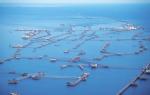
Many oil and gas fields are being developed in the Caspian Sea. The first oil well was drilled on the Absheron Peninsula near Baku back in 1820. In 1949, for the first time, they began to extract oil from the bottom of the Caspian Sea. Salt, limestone, stone, sand and clay are also mined on the coast of the Caspian Sea and the Caspian shelf.
The Caspian Sea washes the shores of five countries: Kazakhstan, Azerbaijan, Turkmenistan, Iran and Russia. For several years now, the Caspian Day has been celebrated in every country, reminding that the Caspian is not just a drinker and breadwinner for the peoples inhabiting its shores, but a very fragile ecosystem.
By the way, in 1978, the World Maritime Day appeared in the calendar of world events, which belongs to the international days of the UN, designed to draw the attention of mankind to the problems of the hydraulic system. There is also an international day of the Black Sea: in 1996, representatives of Russia, Ukraine, Bulgaria, Romania, Turkey and Georgia signed a strategic action plan to save the Black Sea. In this series, the day of the Caspian Sea is also, rather, not a holiday, but a warning, a warning to people about how everything is interconnected in this world and how it is possible, mercilessly exploiting, to lose what is dear to everyone.
Marina Parenskaya
Caspian Sea- the largest lake on Earth, located at the junction of Europe and Asia, called the sea because of its size. Caspian Sea is a closed lake, and the water in it is salty, from 0.05% near the mouth of the Volga to 11-13% in the southeast.
The water level is subject to fluctuations, currently - about 28 m below the level of the World Ocean.
Square Caspian Sea at present, it is about 371,000 sq km, the maximum depth is 1025 m.
Length of coastline Caspian Sea estimated at about 6,500 - 6,700 kilometers, with islands up to 7,000 kilometers. The shores Caspian Sea most of its territory is low and smooth. In the northern part, the coastline is cut by water channels and islands of the Volga and Ural deltas, the shores are low and swampy, and the water surface is covered with thickets in many places. The eastern coast is dominated by limestone shores adjacent to semi-deserts and deserts. The most winding shores are on the western coast in the area of the Absheron Peninsula and on the eastern coast in the area of the Kazakh Bay and Kara-Bogaz-Gol.
V Caspian Sea 130 rivers flow into the river, 9 of which have delta-shaped estuaries. Large rivers flowing into the Caspian Sea are the Volga, Terek (Russia), Ural, Emba (Kazakhstan), Kura (Azerbaijan), Samur (Russian border with Azerbaijan), Atrek (Turkmenistan) and others.
Caspian Sea Map
The Caspian Sea washes the shores of five coastal states:
Russia (Dagestan, Kalmykia and the Astrakhan region) - in the west and north-west, the length of the coastline is 695 kilometers
Kazakhstan - in the north, north-east and east, the length of the coastline is 2320 kilometers
Turkmenistan - in the southeast, the length of the coastline is 1200 kilometers
Iran - in the south, the length of the coastline is 724 kilometers
Azerbaijan - in the south-west, the length of the coastline is 955 kilometers
Water temperature
It is subject to significant latitudinal changes, most pronounced in winter, when the temperature varies from 0 - 0.5 ° C at the ice edge in the north of the sea to 10 - 11 ° C in the south, that is, the difference in water temperature is about 10 ° C. For shallow areas with depths less than 25 m, the annual amplitude can reach 25 - 26 ° C. On average, the water temperature near the western coast is 1 - 2 ° C higher than that of the eastern one, and in the open sea the water temperature is 2 - 4 ° C higher than that of the coasts.
Climate of the Caspian Sea- continental in the northern part, temperate in the middle and subtropical in the southern part. In winter, the average monthly temperature of the Caspian Sea varies from −8-10 in the northern part to +8 - +10 in the southern part, in summer - from +24 - +25 in the northern part to +26 - +27 in the southern part. The highest temperature recorded on the east coast is 44 degrees.
Animal world
The fauna of the Caspian Sea is represented by 1809 species, of which 415 are vertebrates. V Caspian Sea 101 species of fish have been registered, and most of the world's stocks of sturgeon, as well as freshwater fish such as roach, carp, and pike perch, are concentrated there. Caspian Sea- habitat of such fish as carp, mullet, sprat, kutum, bream, salmon, perch, pike. V Caspian Sea there is also a marine mammal - the Caspian seal.
Vegetable world
Vegetable world Caspian Sea and its coastline is represented by 728 species. From plants to Caspian Sea predominantly algae - blue-green, diatoms, red, brown, charovy and others, from flowering - zostera and ruppia. By origin, the flora belongs mainly to the Neogene age, however, some plants were introduced into Caspian Sea a person knowingly or on the bottoms of ships.
Mining of oil and gas
V Caspian Sea many oil and gas fields are being developed. Proven oil resources in Caspian Sea are about 10 billion tons, the total resources of oil and gas condensate are estimated at 18 - 20 billion tons.
Oil production in Caspian Sea began in 1820, when the first oil well was drilled on the Absheron shelf. In the second half of the 19th century, oil production began in industrial volumes on the Apsheron Peninsula, then in other territories.
In addition to oil and gas production, on the coast Caspian Sea and the Caspian shelf is also mining salt, limestone, stone, sand, clay.
Ecological problems
Ecological problems Caspian Sea associated with water pollution as a result of oil production and transportation on the continental shelf, the influx of pollutants from the Volga and other rivers flowing into Caspian Sea, the vital activity of coastal cities, as well as the flooding of certain objects due to an increase in the level Caspian Sea... Predatory hunting of sturgeon and their caviar, rampant poaching lead to a decrease in the number of sturgeon and to forced restrictions on their production and export.