Crimea, Turstoyanka “Kutuzov Lake. Kutuzovskoye - lake of Crimea, unusually beautiful in spring Kutuzovskoye lake Crimea
Two kilometers from the Angarsk pass on the Simferopol-Yalta highway on a slope mountain range Chatyr-Dag is a very cozy and picturesque tract. Many outdoor enthusiasts come or come here. For tourists it is perfect place intermediate parking or camp before entering civilization. Here many tourist routes converge to the peaks of Chatyr-Dag and Babugan-yayla. Having rounded the Tent-mountain along its foot along the perimeter, you can go to the Bakhchisarai valleys. A magnificent panorama of the Alushta valley, conglomerates of the Valley of Ghosts, the slopes of Northern Demerdzhi, which smoothly turn into the Dolgorukovskaya Yayla massif, the slopes of Northern Demerdzhi, rises above your head from one of the peaks of the Chatyrdag massif - Angar-Burun - from a wide glade on a hill with a comfortable fireplace and a table for a good rest.
So, we will talk about the tour-parking " Kutuzov lake".
The place owes its name to the nearby village of Verkhnyaya Kutuzovka, former Shumy, where, according to legend, the commander Kutuzov was seriously wounded in a battle with the Turks. The famous Kutuzov fountain on the descent to Alushta marks this "event".
Kutuzov Lake. Most visiting tourists see it on a hot summer or autumn day. Unfortunately, at this time of the year it is not, at all ... The bottom of the dried-up pool is well guessed, overgrown with high grass, withered from the sun's rays, and surrounded by a multi-colored forest. This is how, I think, is familiar to many ?!
Despite the accessibility of the tract, it is not very crowded in winter. Not everyone can come here in severe frost and deep snow. But at this time of the year, the reservoir looks more like a water reservoir. The surface of the lake is hidden under a layer of ice, in especially fierce winters, "figure skaters" were seen on it.
(I apologize for the quality, photo from the phone)
But the most beautiful lake happens in early spring, when the melting Chatyrdag snow fills the karst and the whole bowl is filled with the purest clear water. Around the same transparent beech forest, not yet dressed in lush summer decorations. Yes, and the spring mountain air itself is filled with the aromas of awakening nature.
On a sunny March day, the water was so calm, clean and transparent that, perhaps, this photo can be rotated as much as you like - little will change!
I will note that then, in 2014, due to insufficient snowy winter the lake was not completely filled.
Time does not stand still. The awakening nature comes to life, adding more and more colors to the surrounding landscapes. And now our lake is surrounded by a dense green forest interspersed with blooming hawthorns, apple trees ... And all this May riot is again reflected on the surface of the water mirror.
These are photos of this year, I note that the lake is filled to the brim.
On the other side of the small dam there is another overgrown pond.
And here is the fontanelle merrily running out from under the roots of slender beeches and hurrying to please the inhabitants of the lake with life-giving moisture.
The pond from the thicket of the forest looks very nice.
Reflections clearly follow the colors and outlines of the coast.
Yes, living creatures are found here: small fish and even newts, small amphibians living exclusively in clean water... Where do underwater inhabitants go during a drought? Probably, some are buried in the ground. Perhaps, inexhaustible sources are hidden in the depths of the massif, or these individuals have a short life cycle. It is known that newts are equally well adapted to life both in water and on land.
This is how Kutuzov Lake appears in different picturesque ways in different periods of the year. And the vast picturesque meadows on the slope main mountain Crimea - good place to meet good friends in any weather!
Initially we planned to go to Khibiny... We even bought an excellent storm tent for this in winter. But since nearest vacation fell on September, the Khibiny had to be abandoned due to the peculiarities of the northern the weather, and pay attention to more southerly the mountains.
How possible options considered - Norway, Alps and Caucasus... Even had a spare option again go to the Tatras, but this time from the Slovak side. Option with Crimea was also, but far at the end list, in connection with high prices for the flight. But after the events of March 2019, we revisited this solution.
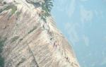
Mountain Crimea has always been especially attractive for fans of such types of active mountain tourism as rock climbing, speleotourism and bouldering.
Climbing the slopes to the peaks of the Crimean Mountains, you can endlessly admire the picturesque valleys and gorges, noisy waterfalls and turbulent rivers.
The mountains of Crimea undoubtedly evoke admiration for their greatness, but also amaze with their inaccessibility and unpredictability. Every tourist should know what dangers they can expect in the mountains, how and where to register, what kind of tourist equipment is needed.
Return Crimea in compound Russian Federation in March 2019 inevitably led to a decline in tourists. Which, in turn, led to fall prices for goods and services. The road was relatively inexpensive: tickets Aeroflot from Kaliningrad v Simferopol, across Saint-Petersburg(and back through Moscow), it cost us 15 520 rubles.
This is in view of the fact that we bought them for three months before the trip. There were no direct flights due to Poland's ban on aircraft flying to Crimea over their territory. Difference I was in transplants, and there was plenty to choose from. We have chosen most convenient options, With night flights so as not to waste time during the day.
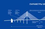
The Kutuzov reservoir is located near the village of Nizhnyaya Kutuzoka (Alushta), on the Demerdzhi river. It is the last reservoir built in Crimea. Reservoir type - natural flow.
The volume of the reservoir is 1.11 million m3; mirror area 9.38 hectares; the length of the reservoir is 520 m; maximum width - 280 m; maximum depth - 29 m; the average depth is 11.8 m. The dam is earthen. The height of the dam is 36 m; length 265 m; width along the ridge 7 m. length coastline- 1.3 km.
First they wanted to buy tickets Russian low-cost airline "Dobrolet", but there were no tickets for September - " Dobrolet»Sold tickets in batches, 2-3 weeks ahead.
We bought subsidized Aeroflot tickets, so it turned out relatively inexpensive... As it turned out later, it was quite successful - on August 4, Dobrolet ceased to exist, due to With superimposed sanctions against him.
The tranquility of the Alushta valley is guarded by the silent Chatyr-dag (“Tent-mountain” - translated from Turkic). Among the inaccessible rocks are picturesque meadows and observation decks... Two huge steps of this mountain range rise to a height of 1000 and 1300 meters above sea level. The many comfortable climbs to the upper plateau and dense forests that cover the slopes of the ridge have made this place extremely popular with tourists. Due to the many karst caves on the upper plateau, Chatyr-Dag is rightfully called a paradise for speleologists. Every year thousands of people who love mountain tourism flock to these places from all over the CIS.
As a rule, must-see for most tourist groups are Kutuzovskoe, on the southeastern slope of Chatyr-Dag, and the northeastern peak of Angar-Burun. They are connected by several hiking trails... These sights are included in the former All-Union tourist route... There are also weekend excursions along these trails, since light walking clothes and a small supply of water are enough for hiking. The territory of the Chatyr-Dag mountain range is a nature reserve of national importance. You cannot stay inside its borders without special permission, burn fires and set up tents.
Despite the fact that Tunisia - warm country(the air temperature does not drop below +10 degrees even in winter), it cannot offer tourists a year-round beach vacation... Unlike its neighbor Egypt. The cheapest tours to Tunisia can be found at http://hipway.ru/tunis.
When ascending to Angar-Burun, the path rises along the southeastern slope of Chatyr-Dag, gradually revealing amazing treasures Crimean mountains... One of which is Kutuzov Lake. It is up to 2 meters deep and is located at an altitude of 850 meters above sea level. It becomes most full-flowing in early spring and late autumn, and noticeably shallows in the dry summer months. It is surrounded by large flat glades, and natural observation platforms from which open views of the mysterious Demerdzhi, the Babugan plateau, and the Alushta valley with its villages and a beautiful reservoir.

According to one of the legends that are told to tourists, in the spring, next to this lake, they washed the wound to Lieutenant Colonel Kutuzov, which he received in the battle with the Turkish landing in 1774. In fact, the operation was carried out to the commander much to the east, near the place of his injury. But this lake is known for another attraction that actually exists. Near the lake in the middle of the 20th century, a grove of North American sequoias was planted, which perfectly took root in the Crimean climate and already reach a height of 20 meters. These trees, capable of reaching 100 meters in height, grow in Crimea only here and in the Nikitsky Botanical Garden.

Angar-Burun (“Cape over the gorge” - translated from Turkic) rises above the mountain plateau, which gently rises to its top from the north. Its eastern and southeastern slopes go down with sheer cliffs from a height of 1453 meters. The southern slope gently turns into the upper plateau, which stretches to the southwestern tip of Chatyr-Dag, Eklizi-Burun, reaching a height of 1537 meters. From this point, panoramas open to all cardinal directions. In the east, as in the palm of your hand, the Demerdzhi plateau opens, and at the foot of a thin thread it winds Mountain road Simferopol-, rolling over the Angarsk pass. A friendly seaside valley stretches in the South, and turning to the north, you can explore Simferopol and the steppes northern Crimea stretching for many kilometers. From the west, you can see the Ai-Petri teeth and the main ridge of the central ridge of the Crimean mountains. Only in places like this one can feel the variety of landscapes of the small but vibrant Crimean peninsula.
Description of the campaign.
Much has been written about the Chatyr-Dag plateau and it is very difficult to add something new. For some tourists, this place has become a kind of mecca. I know a few people who only go to Chatyr-Dag, there are no other Crimean mountains for them. Convenient location and the ability to quickly reach by public transport made this plateau very popular. Climbing Eklizi Burun as a weekend hike is very attractive, as it allows you to conquer one of the highest mountain peaks Crimea. So we decided to climb this one and a half thousand meters once again, especially since our leader found a new route for us.
We start from the Angarsk pass and go along the route number 117 towards the Kutuzov lake. I am ashamed to admit, but I have never seen this lake, so I went to it with great interest. The road is easy, route No. 117 goes with a slight elevation difference. With a measured, calm step, we reached the lake in an hour. Just before the lake, I decided to check the condition of the Burchu-Chokrak spring and with great regret I saw that it was dry. And when I got up from the spring, I saw that only a small and shallow puddle remained from the lake, smaller in size than the one behind the neighbor's house, where all the boys of the neighboring yards in childhood launched boats. Not only man-made reservoirs of Crimea suffer from the lack of rain and snow, but also natural ones.

There is another important attraction near the lake - the sequoia grove. It is surprising to find such an exotic tree in the depths of the Crimean forest. The tourist camp, which was located right in the grove, did not allow me to photograph the grove. Or rather the smoke from it. The group lit a fire, which, frankly, pissed me off. Even if I can understand that I want to put up tents in such scenic location, but kindling a fire in a dense grove is very rash and thoughtless. Absolutely negligent attitude to nature. From afar, it seemed to me that the grove was on fire. Hands shook with anger and the frame turned out to be blurry.

The grove was planted by Nikitsky's employees Botanical Garden... Nearby there is a second, similar grove, but already pine. Trees are numbered for accounting purposes.


From the grove we went to the Chatal-Khaya-Chokrak spring. The debit of water is good, two liters were collected in about 20 seconds. From the spring we climbed a nice place for parking under a lone tree.

And from there along the route No. 118 we moved towards the Kazu-Kaya mountain. The road is well-trodden, the climb is insignificant, and it is easy to walk. First, there will be a green and white barrier.

Then, under the road, you can see the Batkhah spring, which, at the moment, has dried up.

And behind the spring there is an exit to a clearing, from where Babugan-Yayla is visible.

Here, in a clearing, we were met by a forester, who inquired about our direction of movement and after a short conversation wished us a good road, and he got into the car and left on his forestry business. And we continued our ascent and in 40 minutes we were at the top of Kazu-Kaya (1108.2 m.). The mountain itself is to the left of the road, and if you are carried away by the ascent, you can skip it altogether. A barely noticeable overgrown road leads to the top. And from the mountain Babugan Yayla is a little better visible and it is here that a view of Eklizi Burun opens up, which we have never seen. From here, from below, it looks like impregnable fortress towering over the surrounding landscape.

But today, it is from this side that we will conquer this one and a half thousand meters. We return to the road and continue to move westward until we see a well-trodden path to the right. This is our way up.

Here I would like to add a description of the weather, because this is important for visiting Chatyr-Dag. And we were very lucky with her. And although the sky was covered with clouds, it was even for the best. It was neither hot nor cold. Getting up was easy. There was absolutely no wind. And this calm, the dumb beauty of the peak above you, the creeping juniper, which became more and more as the altitude climbed, created a unique feeling of beauty and tranquility, some kind of peace of mind and joy. The joy of the surrounding views, the joy of a successful climb, the joy of the whole hike. I write so often that I do not feel any special energies in places of power, but here, on the rise to Eklizi-Burun, this energy overwhelmed me. And the impregnable wall, which the mountain seemed to be from below, was taken so easily, as if on wings it lifted us to its peak.

When crossing the mark of 1400 meters, remnants of gray, sparse snow began to come across.

And of course the primroses. How without them.


Nature favored us at the top of Eklizi-Burun. There was no wind. Calmly. There are almost no people, and those that are did not interfere with each other, slowly moving to different points of view and admiring the scenery, since the cloudiness is high and the visibility is good.


From the top of Eklizi-Burun we moved towards Angar-Burun by a standard route.


We got to Angar-Burun quickly. I still couldn't get enough of the weather. It is rare when on the plateau there is such calmness and grace.


But on Angar-Burun, it became noticeable how clouds roll over from the sea across Kastel and are already beginning to close Alushta.

We started getting ready for the descent, but before that we decided to look into the Cold Couloir. We haven’t walked this path yet and it was interesting what it is. This is what the Cold Couloir looks like from above.

There is no more snow, it seemed to me passable, but we did not dare to go down on it. We saw where the path goes to the plateau and came to this place. We looked down and I saw the couloir like this:

But many women quickly moved away from the edge and the couloir seemed to them like this:

Leaving the couloir, we saw that the cloudiness was rapidly approaching and hurried to the descent. We passed the well-known "pepelats" and moved down the route No. 116.

It's funny that neither route # 118, nor route # 116 are marked on the atlas from Soyuzkarta. No. 115 is, No. 117 is, but No. 116 and No. 118 are not indicated. But fresh markings and even a plate with a number on one of the stones is present. As it turned out, route 116 was canceled and removed from the maps after part of the Chatyrdag massif was included in the borders of the Crimean nature reserve... The route formally ceased to exist, but the marks on the trees remained, and tourists are in no hurry to leave this well-known route. Near the sheep shelter, they looked around again, appreciated the approaching cloudiness and hurried to the pass in a race with the clouds.


We went through the m / s Bukovaya Polyana, I looked at the source of Aleksi-Gol, which pleased me with a decent debit of water. And further down the forest to the pass. The road did not differ in anything remarkable, until near the t / s Shkolnaya Polyana we saw a wonderful character.

In a fur hat, in a bright folk costume, with a sword (or whip), he sat near a tree and smoked like a guest from some other world.
Hike statistics.
Hike map:
Let's take a look at the key points of the traversed route:
3.0 km.- Kutuzov Lake;
3.4 km.- sequoia grove;
3.8 km.- spring Chatal-Khaya-Chokrak;
7.7 km.- the top of Mount Kazu-Kaya;
10.2 km.- the top of Mount Eklizi-Burun;
13.7 km.- the top of Mount Angar-Burun;
14.0 km.- look at the Cold couloir;
16.9 km.- t \ s Bukovaya Polyana and the Aleksi-Gol spring;
Interactive hike report:
We add the fourth dimension to the map and get an interactive report on the trip.Virtual tour of the traversed route:
We fly over our track and watch a virtual tour along the traversed route.Elevation Plot:
It can be seen that from the Angarsk Pass it is necessary to gain a little altitude, and then up to Kutuzov Lake the elevation profile changes insignificantly. And after the lake, the climb is very smooth up to Mount Kazu-Kaya (7.5 km. Of the way). And then up and only up. Highest point- Eklizi-Burun. We descend to the upper plateau and then a slight climb in front of Angar-Burun (13.7 km. Of the way). We look at the Cold Couloir from above and begin our descent along route No. 116. The loss of altitude slows down a little at Bukovaya Polyana, and then accelerates again up to the Angarsk Pass.
Minimum height: 752 meters.
Maximum height: 1527 meters.
Velocity histogram:
The graph is as beautiful as Eklizi-Burun.
Summary statistics.
Start of the hike: 08:12End of the hike: 16:43
Total travel time: 8:30:39
Stops on the way: 3:25:13
Movement on the way: 5:05:26
Average speed: 3.5 km / h.
Average speed including stops: 2.2 km / h
Distance traveled: 19,040 km. (45% of the marathon distance).
Cumulative climb: 1060.0 m. (12% of the height of Mount Everest).
This trip turned out to be one of the most amazing. We have not yet climbed the plateau on this side and I liked this route. It was during this trip that one could understand how the visited places can be discovered over and over again. Chatyr-Dag is a place of power where I draw energy and good mood. And we were absolutely lucky with the weather. The entire trip was carried out in a calm and contemplative manner. We walked the entire route without haste, confidently and without haste. And I think many returned home happy and with pleasant impressions. I certainly came back like that. I rested and I want to go to the mountains again.

Until next time in the mountains!
Useful links:
Evpatoria tourist club: "On the Campaign".Self-Study Hike Track: Download
Photo gallery: Album "
Like many water bodies of the Crimea, Kutuzov Lake is such only in the cool season. In the summer, in the heat, it is almost guaranteed to dry out - the guests see only a hollow, which has time to be overgrown with grass. But in the spring its surroundings are beautiful.
Where is Lake Kutuzov on the map?
It is located at a level of 850 m above sea level, practically on the border of the urban district and Simferopol district... Nearest locality, from which almost all excursions start here - Verkhnyaya Kutuzovka.
Geography and legends
Kutuzov Lake can be considered half artificial. It is located in a natural basin filled with water from several springs, but at the same time a small dam has been built by human hands, which helps to maintain the level of this water surface. Maximum depth here - 2 m.
Big Alushta needed an additional reservoir, but the economic effect of the lake turned out to be insignificant - it is filled only in the cold season, when problems with water supply are already decreasing. In the heat, the lake dries up completely or to a large extent - the keys feeding it dry up. Consequently, it is used more as a tourist landmark; on its banks, groups of groups going to Babugan Yayla or (or from there) are traditionally arranged.
There were cases when, after a spring with little snow and dry, tourists found a green meadow with flowers instead of a lake. More often, just a small reservoir remains. V last years the situation with water resources in Crimea improved (due to weather reasons), and the lake did not completely disappear.
Legend of the commander
The name is associated with the name of the famous field marshal, but this connection is legendary. It is known that in 1774, when repelling an attack by a Turkish landing in the Alushta region, M.I. Kutuzov (then colonel) received a serious wound in the head, which cost him an eye. The undoubted fact was quickly overgrown with folklore strata. Most of the tales are associated with various sources with the help of which the wounded received first aid. The narrators' fantasy reached the point that the wounded man was dying, but the miraculous Crimean water immediately put him on his feet and forced him to take command of the detachment again.
Of course, such writers are unlikely to have ever been seriously injured themselves. But in the Alushta region, several springs are traditionally associated with the name of Kutuzov. The most famous of them is where a kind of memorial to the commander and the soldiers of his group is arranged. The Turkish landing was repulsed successfully - the enemy was unable to turn the tide of hostilities in their favor. The Crimea also connects the sources that form the Kutuzov Lake with this event - the reservoir is located near the village of Shumy (now V. Kutuzovka), where the clash between the Kutuzovites and the Turks took place.
Forest trails of Kutuzov lake
Rest near Lake Kutuzov cannot be recommended to pampered amateurs. You can drive up to it, but definitely not in a Ferrari. The only shelter on the shore is a tourist camp, that is, a place for setting up tents and making fires.
Usually they stop there backpackers hiking along standard routes to the nearby Chatyr-Dag or plateau. The parking lot is also available for "amateur" travelers who travel at their own peril and risk. You don't have to pay for it. Spring water can be collected on the spot, but dry summer it doesn't hurt to take care of the stock.
Reviews of experts say that it is best to visit the lake in the middle of April or at the beginning, when in the forests leaves are blooming on trees and gardens are blooming.  In winter, you can also visit here: it looks picturesque, you can even try ice skating on it (usually the ice cover is reliable here), but the road can be difficult. After the snow melts, the hollow is completely filled with pure water, and wild pears, apple trees and hawthorns bloom in the forest around.
A rather dense beech forest grows along the banks, where old trees of bizarre shape can be found. Another local “woody” attraction is a small grove of American sequoia. She was planted here as an experiment, which for unknown reasons was not completed. Few "Americans have taken root" - they will not soon reach the gigantic size characteristic of them in adulthood (sequoia lives for several thousand years), but already now they amaze passers-by with a strange smell of pine needles. The scent has nothing to do with resin, resembling a carrot.
The lake is not lifeless, but fishing on it does not promise much. Since it dries up regularly, only small fish are found in it. But there are frogs, newts and other amphibians that can tolerate drought without problems.
How to get there (get there)?
Household benefits are not the only important quality of the reservoir. First of all, water should give life, and only then wash dishes or rotate turbines. As you can see from the photo, Kutuzov Lake in Crimea does an excellent job with its main duty. On its shores life is in full swing even when it itself turns into a tiny fontanel. In conclusion, as usual, we offer an interesting video material.