The absolute height of Altai. Location of Altai mountain ranges
Ukok Plateau (Zabara Alexander / flickr.com) Ukok Plateau (Zabara Alexander / flickr.com) Ukok Plateau (Zabara Alexander / flickr.com) Ukok Plateau (Zabara Alexander / flickr.com) Ukok Plateau (Zabara Alexander / flickr.com) Ukok Plateau (Zabara Alexander / flickr.com) Ukok Plateau (Zabara Alexander / flickr.com) Ukok Plateau (Zabara Alexander / flickr.com) Ukok Plateau (Zabara Alexander / flickr.com) Katunsky Nature Reserve in Altai (Igor Shpilenok / wikimedia. org) Black taiga of the Altai Nature Reserve (Bondarevskaya S.A. / tigirek.ru) Black taiga of the Altai Nature Reserve (Golyakov P.V. / tigirek.ru) High-mountain plant belt, subalpine meadow - Altai Nature Reserve (Semyonov Victor / tigirek.ru) Kucherlinskoe lake (Eric Pheterson / flickr.com) Lake view (Obakeneko / flickr.com)
Altai Mountains The beauty of their snowy peaks, the rapid flows of rivers and the tranquility of lakes, surrounded exclusively by Altai vegetation and representatives of the animal world, not found anywhere else, have been attracting people for thousands of years.
And if now they are a place of pilgrimage for tourists, then archaeological excavations indicate that life was seething here back in the Stone Age. And about later settlements I can see cult monuments, mounds and burial grounds, where not only metal, wooden and leather household items were found, but also embalmed bodies.
So rich cultural heritage, unique nature and the landscape of the Altai Mountains has long attracted the attention of scientists, archaeologists and historians who, with the goal of preserving this beauty for posterity, even in the beginning XIX century raised the issue of creating a protected area in Altai.

Katunsky Nature Reserve in Altai (Igor Shpilenok / wikimedia.org)
In 1932, more than 860 thousand hectares of mountain and forest lands came under state protection under the name “Altai Nature Reserve”.
At the end of the 19th century, or to be more precise, in 1991, the state took another part under its protection. Gorny Altai- Katunsky Nature Reserve.
And this is another 159 thousand hectares of forest, mountain ranges, rivers, lakes and the highest point of Altai - the two-headed Beluga Mountain.
At the same time, a number of scientists worked to ensure that these protected areas were included in the list of world heritage sites under the jurisdiction of UNESCO. And in 1998, these two reserves, together with a unique area where the most valuable archaeological finds were discovered - the Ukok Plateau, were included in the list of UNESCO protected areas under the single name "Golden Mountains of Altai"
Altai Nature Reserve
The main reason why a certain territory is declared a protected area is the desire to preserve its pristine nature, rare plants and the world of animals living in this territory.


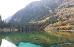
Evening on Lake Kucherlinskoye (Oleg Balashov / helgi.35photo.ru)
With a backpack on your shoulders, climbing up along the bed of the Kucherla River, coming into contact with the unique beauties of the Altai forests, after 2 days you can walk on your own feet to the recreation center “Kucherlinskoe Lake”, located on its shore. There is also an equally interesting route leading to Lake Akkem. a tourist route, however, in this lake, unlike the Kucherlinsky reservoir, there is no fish. And mostly climbers rush there with backpacks on their backs.
On the southern slope of the Katunsky ridge at the foot of Mount Belukha, another river originates - the Katun. Its name comes from the ancient Turkic word “kadyn” - mistress, but this river is actually the water “mistress” of the Altai Mountains, giving rise to the great Siberian Ob River.
The Katunsky Reserve, like the Altai Reserve, is rich in hundred-year-old cedars, larch and pine trees. Morals and roe deer, wolves and bears also run here, and high in the mountains, at the foot of Belukha, the snow leopard listed in the Red Book, the Siberian ibex and other representatives of the Altai fauna roam.
This plateau of the Golden Mountains of Altai is located at an altitude of more than 2.2 thousand m above sea level, surrounded by snowy mountain ranges, which are even higher - more than 2000 m above the plateau (Tabyn-Bogdo-Ola - 4080m, Nairamadan - 4374m).

In geopolitical terms, the uniqueness of the plateau lies in the fact that, passing along its perimeter with south side You can visit four countries of the world at once - Russia, Kazakhstan, China and Mongolia in a short time.
The vegetation on Ukok is relatively poor. Long cold winters with virtually no snow, spring starting in July, snowfalls in June, despite the fact that sometimes the sun warms the air to +25*C - only high-mountain grasses survive in these conditions.
Nevertheless, Kazakh shepherds still drive their sheep to this pasture, and mountain geese, black storks and vultures, golden eagles, griffon vultures and other alpine birds feel very comfortable here. And somewhere among the snowy peaks a snow leopard wanders alone in search of food.

Ukok Plateau (Zabara Alexander / flickr.com)
Shallow rivers snake through the plateau, originating from melting glaciers, and as the riverbed approaches, the Jazator River merges with its waters. From a bird's eye view, you can see how, between the river snakes, here and there, large and small lakes shine with brilliance, formed in small lagoons once created by glaciers.
There are minerals on the plateau, as can be guessed from the name of its heights. So, not far from the Teply Klyuch pass, radon springs bubble up from the ground, and Mount Molybdenum, whose height reaches 2723 m above sea level, stores molybdenum deposits in its depths.
Altaians consider this area sacred. They are still against holding it here archaeological excavations and are striving to return to its place the mummy of the “Altai princess” discovered here. By the way, this discovery of Russian archaeologists in 1993 shook the whole world.

Archaeologists, studying inch by inch the secrets of the permafrost soils of this plateau, find here traces of the former presence of the ancient Scythian (VIII-X century BC) and Afanasyev tribes.
Today, there are about 600 archaeological sites on the Ukok plateau, which are of particular interest to the world community as historical monuments, including not only Scythian burial mounds, but also rock paintings from the Stone Age period.
Therefore, the Ukok Plateau is included in the list of “Golden Mountains of Altai” as an area under the jurisdiction of UNESCO.
“Golden Mountains of Altai” is not just a name - these are mountains with snowy peaks, dense forests with hundred-year-old cedars and pines. These are stormy rivers and waterfalls, the quiet surface of deep lakes, these are roe deer and deer, wolves and bears, these are golden eagles and black storks. These are mounds with the embalmed bodies of former celebrities and leaders and rock paintings, as an echo of the life that once upon a time flourished here. This is all that cannot be described in words, this is what needs to be seen and felt.
The Altai Mountains are a complex system of ridges, divided by vast pits and deep rivers. They simultaneously cross the borders of several countries: Russia, Mongolia, Kazakhstan and China. Their total area is about 742 thousand km2.
A little history
There is a legend that before the Flood, the Altai Mountains were mighty heroes. But after that the earth lost its hardness and was not able to support the giants, so they turned into mountains in which their spirit still lives.
For many centuries this territory was a “corridor” between Central Asia, Mongolia and Siberia.
Many traces of human habitation are found here: Scythian burial mounds, stone sculptures of Turkic peoples, mysterious writing and other rock paintings. People have lived in Altai since ancient times. Initially it was a caveman, later Caucasians appeared, then (mid-1st millennium BC) - Scythian tribes.

A thousand years later, the Turks came to the Altai Mountains and lived here until dominance over the territory passed to the Mongol tribes. In the 17th century they were replaced by Dzhugars. After the defeat during the attack by Chinese troops, the local population began to seek protection from Russia, which at that time was expanding its borders on a large scale.
Relief
On the territory of Russia, mountains are located in the Altai Republic and Altai Territory. This is the most high part Siberia.
They were formed in different eras, due to which they have all kinds of reliefs, namely:
Flat terrain;
Low mountains (up to 500 m);
Srednegorye (up to 2000 m);
Highlands (up to 4000-4500 m);
Intermountain pits.

Karas, peaked peaks, landslides, ridges, screes - these are already forms of relief that the Altai Mountains have. There are also rivers here that flow into the valleys and form clean lakes. The water level in them varies depending on the time of year, since they are fed only by snow.
Under the influence of various weather phenomena (wind, snow, rain, frost and heat), the Altai Mountains are constantly being destroyed. The waters carry away the upper layers of the surface, the peaks crack, which is why screes can be observed quite often. There are about 300 caves here.
Peaks
The Katunsky ridge is the highest in Altai, about 15 km long and 3200-4000 meters high. Its peaks are always white - the snow does not melt here, only blocks of ice of different sizes constantly fall down. The Katunsky ridge is one of the most visited by tourists. It offers an excellent overview of the highest mountain - Belukha. Its peak is 4509 meters above sea level.
Famous interesting fact- The beluga whale is located the same distance from three oceans: the Pacific, Indian and Atlantic. It is surrounded on all sides by glaciers, which is how it got its name.
The local population has many legends associated with Belukha; they believe that the mountain is sacred and that they still live on it today evil spirits. They can punish anyone who disturbs her peace. Buddhists believe that Belukha hides the entrance to the legendary country (Shambhala).

Kolban is another peak of the Katunsky ridge. From a height of 3022 meters it offers beautiful all-round panoramas.
One more ridge of Altai cannot be ignored - Chuisky. It rightfully ranks second in size. It is usually divided into two: North Chuysky and South Chuysky.
The first one is very popular among tourists due to its landscape. Many come here to look at the alpine meadows, beautiful mountain lakes and the eternally snow-covered highlands.
The South Chuysky ridge is difficult to pass due to its topography; it practically consists only of glaciers.
Mountains Altai Territory not as high as the Altai Mountains. But they also attract many tourists. Mount Sinyukha (height 1210 meters) is very popular. Here on one of the slopes there is a holy spring; an Orthodox cross was installed next to it in 1997.
Lakes
The Altai Mountains, photos of which can be found in this article, are also rich in lakes. There are about 20 thousand of them here.
The largest is Teletskoye, it ranks second in depth after Lake Baikal. There is still much debate about its origin.
The lake is stretched out in a strip 80 km long. It has its own special climate, so the weather can change several times during the day. The winds dominate here. The lake has very clear water; even in winter you can see the bottom through the ice. Both tourists and fishermen love to come here.

Most large river The Altai Mountains is Katun, 688 km long. Its source is the Gebler Glacier at an altitude of 2 km above sea level. The waters of this river are cold; not everyone can swim in it.
Lake Aya is another matter; in summer it warms up to +25 °C. Surprisingly, not a single river flows into it, but the water level is always the same.
It is impossible to ignore the Karakol Lakes. There are seven of them in total. They were born by glaciers, so even in summer the water warms up only to +11°C. Here lies the border of larch, cedar forests and alpine meadows, striking the eye with their beauty.
Altai Mountains (photo): flora
The local flora is rich in its diversity. Here you can see the vegetation of the European part of Russia, Eastern Kazakhstan, as well as central and northern Asia.

The main part of the Altai Territory is covered with forests. A special feature of this area is the ribbon pine forests.
In the mountainous part of Altai, trees such as larch, cedar, fir, and birch grow. There are also many shrubs here: lingonberry, honeysuckle, blueberry, raspberry, blackberry, maralberry, meadowsweet, cinquefoil, juniper.

In spring and early summer, the mountain slopes and plains turn into bright carpets of various colors. There are many medicinal plants here, some of which grow only in Altai.
Animal world
Forests and steppes provided the Altai Mountains with a variety of fauna. About 250 species of birds and 90 species of mammals live here. Some of them are even listed in the Red Book.
A feature of the animal world is the presence of endemic species. They can live both on plains and in mountainous areas. Prominent representatives are the Altai mole, tundra partridge and mountain turkey.

The taiga is preferred by brown bear and elk. The first one can migrate from forests to alpine meadows during the summer in search of tasty plant roots, herbs, mushrooms, and fish. However, by autumn he always returns to the taiga.
Ungulates (roe deer, elk, musk deer, deer) make seasonal transitions from one zone of the Altai Mountains to another.
In the forests you can see wolverine, lynx, chipmunk, and ermine. Among fur-bearing animals, sable and fox stand out.

Where the Altai Mountains turn into steppes, birds of prey live (kestrel, falcon, buzzard), the golden eagle dominates the peaks, and the forests are dominated by hawks, owls and eagle owls.
Belukha is the most high mountain Altai. The sacred mountain has many local names: Kadyn-bazhi - “Top of the Katun”, Ak-suru - “White Giant”, Musdutuu - “Ice Mountain”, Aktau - “ White Mountain"; judging by the names of Uch-Syumer, Uch-Syuri, Uch-Ayry - “Three hills”, “Three spiers”, “Three branches”, the mountain once had three peaks. Poets, philosophers and religious thinkers call it the “Silver Thread of the World”, “Planetary Throne”, “Shield of Fiery Power”, “Tower of the Mother of the World”, “Fortress of the Diamond Throne Buddha”, “Stronghold of the One God”.
Scientists see, first of all, a granite massif covered with glaciers, composed of rocks of the Cambrian period. To this day, tectonic movement continues - an uplift that began in the Paleogene era, so this mountain is a real museum various geomorphological processes and landforms. Two peaks in the shape of irregular pyramids - Eastern Belukha (4506 m) and Western Belukha (4435 m), with a drop to 4000 m (the so-called "Belukha Saddle") between them - crown the Katunsky ridge of Central Altai in the south Western Siberia, where the borders of four countries meet: Russia, Kazakhstan, Mongolia and China. The mountain is almost vertical in the north (the so-called Akkem wall from the side of the Akkem glacier) and more flat in the south, where the Katun River originates from the Katun glacier (otherwise known as the Gebler glacier).
People have inhabited the intermountain valleys of Altai since the Paleolithic era (the first settlements appeared about 1.5 million years ago. In the 7th-3rd centuries BC, Altai was inhabited by the Pazyryk Scythians, then they were replaced by the Huns and Sarmatians, from the mid-5th century - Turks, the ancestors of modern Altaians, who formed a large medieval state of the Turkic Khaganate (monarchy), which, along with Altai, included the territories of Manchuria, Mongolia, East and West Turkestan, Kazakhstan and North Caucasus. In the XVII-XVIII centuries. Altai is part of the Dzungarian state, liquidated by the Qing dynasty (China) during the Third Oirat-Manchu War (1755-1759). At the same time there was expansion Russian Empire, during which in 1717-1747. Northern, and in 1756 southern Altai became the possessions of the Demidovs.
Exploring and conquering this not the highest, but difficult to climb and spiritually significant mountain in the world has become a matter of honor for many. But only in the 20th century.
The slopes of Belukha, on average up to a height of 2600 m, are covered with glaciers (currently 169 are known, with a total area of about 150 km 2), which is reflected in the name Belukha, i.e. “White”. Due to the difficulties of climbing the glacial slopes and the sacred tradition of the local population to bypass Belukha for quite a long time, no one dared to climb to the top, as one of the encyclopedic publications of 1891 laments. Its height was approximately calculated in 1835-1836. German doctor of medicine, geographer Friedrich August von Gebler (1781-1850) who worked in Russia. The Russian botanist, geographer and traveler Vasily Vasilyevich Sapozhnikov (1861-1924) reached the “Belukha Saddle” in 1895, who brought greater accuracy to the measurements.
A detailed study of Belukha glaciers was carried out already in Soviet times by the Tronov brothers - glaciologist (ice researcher) and climatologist Mikhail Vladimirovich (1892-1978) and chemist Boris Vladimirovich (1891-1968). They also have the honor of the first ascent of Belukha in 1914: they managed to conquer its higher eastern peak only the third time (the first unsuccessful attempt to climb was made back in 1907 by a group of Russians, and in 1909, just as unsuccessfully, by a group English climbers).
The snow-white crown of the Altai beauty was captured in their paintings by Nikolai Konstantinovich Roerich (1874-1947) and the outstanding landscape painter of Altai origin Choros-Gurkin - Grigory Ivanovich Gurkin (1870-1937). In the wake of the revolution in 1917, he, as the most famous representative of the indigenous nationality, was persuaded to head the Karakorum-Altai district government, and in 1919 the Kolchakites arrested him “for separatism and treason.” Released on bail, the artist hastened to flee abroad. In 1925, he was persuaded to return to Soviet Russia, where he painted pictures, drew posters and illustrated folk epics until 1937, until he was accused of nationalism; died in the dungeons of the NKVD, rehabilitated in 1956.
At the end of the 20th century. Belukha is turning into a center of extreme sports and tourism. Today, different climbing routes are known, all of them are rock and ice.
Among the animals and birds there are rare specimens, for example, the snow leopard and golden eagle listed in the Red Book. The mountain, together with its ecosystem, was first declared a natural monument of the Gorno-Altai Autonomous Okrug, and then a World Heritage Site. natural heritage UNESCO under official name « ».

general information
The highest point in Siberia.Administrative affiliation: border Ust-Koksinsky district, Siberian federal district, Russian Federation.
Ethnic composition: Altaians (indigenous people) are the majority, Kazakhs - up to 6%, there are small groups of Russian Old Believers who moved here more than 200 years ago.
Religions: Burkhanism (local belief with elements of Buddhism and shamanism), Buddhism (Altaians), Orthodoxy (Russians), Islam (Kazakhs).
Largest river: Katun.
Largest lakes: Kucherlinskoye, Akkemskoye.
Largest glaciers: Sapozhnikov Glacier 10.5 km long, area 13.2 km 2; The Big and Small Berel glaciers are 10 and 8 km long and 12.5 and 8.9 km 2 in area.
Immediate settlements: Ust-Koksa village.
Distance from China and Mongolia: about 100 km.
Numbers
Eastern Belukha: 4506 m.Western Belukha: 4435 m.
Belukha Saddle: 4000 m.
First ascent: 1914, Tronov brothers.
Glaciers of Mount Belukha: number - 169, area - 150 km 2, 50% of all glaciers of the Katunsky Range.
Ice movement speed: from 30 to 50 m per year.
Climate and weather
Sharply continental with short hot summers and long frosty winters. Varies according to altitudinal zonation.Average annual temperature in the valley: 0…+5°С
Average annual temperature at the summit:-6°C
Minimum summit temperature: in winter up to -45°C, in summer up to -20°C.
Curious facts
■ Complex cosmological ideas connect Belukha with Tibet and India. Locals We are sure that Belukha and Tibet are connected by very real cave passages. According to one version, Indian mythological sacred mountain Meru (the center of all universes) is the Altai Belukha.■ The number three carries important symbolism for Belukha. It is believed that three religions meet here: Christianity, Buddhism and Islam; Altai, Himalayas and Pamirs are connected through Belukha; the mountain is located at approximately equal distance from three oceans: the Pacific, Arctic and Indian.
In the extreme southeast of Western Siberia between 48° and 53° N. w. and 82°-90° E. the vast Altai mountain system extends across. The maximum absolute heights of the Siberian Altai range from 350 to 4500 m, and the increase in the heights of mountain ranges and the bottom of river valleys occurs in the southeast direction. In the northeast, Altai touches the Kuznetsk Alatau and Western Sayan; the Mongolian Altai departs from it to the southeast, and the hilly steppe spaces of the Kazakh hillocks with absolute heights of 300-500 m (with gradual transitions to Altai) are adjacent to the southwest. In the north and north-west, Altai is quite sharply limited by a steep erosion-tectonic ledge up to 300-500 m high, which can be traced approximately 52° N. w. Further to the southwest the Altai border becomes less distinct; its continuation here are low granite manes, extending far into the steppes of Kazakhstan.
The Altai mountain ranges are fan-shaped. The largest high-mountain junction here is the border with Mongolia mountain range Tabyn-Bogdo-Ola, located in the upper reaches of the river. Argut, a tributary of the river. Katuni. Its main peak, Kuitun, reaches 4358 m in height and bears powerful glaciation. From it, beyond the borders of the USSR, the Mongolian Altai extends to the southeast, in the latitudinal direction the system of ridges of the Southern Altai goes to the west, and the border mountain range - Sailyugem (with elevations up to 4029 m) stretches to the east, which begins the Eastern Altai. Between these mountain systems Southern and Eastern Altai, inside the wide-open arc they form, is the Central, or Inner Altai, the continuation of which is the ridges of the northwestern part of Altai.
Southern Altai consists of the ridges (in the direction from east to west): Tarbagatai, Sarym-Sakty and Narymsky, from which several mountain ranges are separated to the south and southwest, going towards the Zaisan depression (Kurchumsky, Azu, etc. ridges) , with little dissection and high, impassable passes. Their slopes are asymmetrical - gentle to the south and steep to the north. The ridges of Southern Altai are watersheds between the waters of the tributaries of the river. Black Irtysh and the river system. Bukhtarmy. In the highest areas they are covered with eternal snow and numerous glaciers. In the eastern part of these ridges the heights reach 3915 m, and in the western part 3350 m. The highest point of the Southern Altai (Mount Kirey) is 3790 m. The Southern Altai is characterized by high passes.
Eastern Altai consists of a series of ridges located on the watershed between the Ob, Abakan and Kobdo river systems. These are the Sailyugem, Chikhacheva and Shapshal ranges. Sailyugem (absolute height up to 4029 m) stretches along the border with the Mongolia and serves as a watershed between the river systems. Ob (argut, Chuya, Bashkaus, Chulyshman rivers) and rivers. Kobdo. From the Chikhachev ridge the Chulyshmansky, Kuraisky and Aigulaksky ridges extend to the west, which in turn separates a whole fan of ridges filling the space between the river. Katun and Lake Teletskoye.
In the upper reaches of the river Ony (Abakan river system) Eastern Altai adjoins the Western Sayan through the Shapshal ridge. Characteristic features of the relief of Eastern Altai are significant elevation, comparative smoothness of mountain ranges with more or less gentle slopes; Dome-shaped peaks and significant development of raised, hilly plains (plateaus) are also typical. Of these plateaus (the so-called “steppes”) we will name the Chui steppe, the Kurai steppe, the Chulyshman plateau, the Ukok plateau, located at altitudes from 1500 to 2300 m and being the threshold to similar high steppes and semi-deserts of Central Asia.
Central, or Inner Altai. Two main mountain ranges (northern and southern) are clearly distinguished here, having an almost latitudinal extension and gradually decreasing in the direction from east to west. The southern chain consists of the high massive Katunsky ridge (Katunsky squirrels) with the most high point Altai - Belukha Mountain (4506 m).
A direct continuation of the Katunsky squirrels to the east is the river gorge separated from them. Arguta ridge South Chuya squirrels with main peak- Mount Irbistu (up to 3958 m). To the west of the Katunsky ridge, separated from it by the river valley. Katun is located in the Kholzun ridge with altitudes up to 2600 m. The mountain ranges here rise above the snow line and carry heavy snow and the largest glaciers of Altai.
The northern chain of ridges of Central Altai starts from the river. Chui North Chuya squirrels with the complex mountain unit Bish Iirdu (height 3899 m) and continues further to the west under the name of the Terektinsky ridge (up to 2891 m altitude). It is followed by the Korgonsky (2500 m), lower Tigiretsky (2255 m) and Kolyvansky (Mount Sinyukha - 1197 m) ridges. The last of them is gradually lost in the steppe plains.
A number of ridges extend radially from the Kholzun ridge to the west, sometimes separated into the system of ridges of Western Altai - Ulbinsky (1792 m), Ivanovsky (up to 2674 m), Ubinsky and others.
To the northwest and north of the Terektinsky and Korgon ridges there are a wide fan of mountain ranges- Seminsky (2506 m), Cherginsky (2010 m), Anuysky, Baschelaksky (2359 m). All of them are heavily eroded and have the appearance of medium-altitude mountains, without reaching the upper limit of the forest zone.
Central Altai is characterized by a large contrast of heights and the presence of wide intermountain depressions with a flat bottom (Uimonskaya, Katanda, Abai steppes), with absolute height up to 1000 m. As a rule, the degree of exposure of the Altai ridges increases in the direction to the southwest, and their passage in the same direction becomes more difficult.