Coastline of the Black Sea: description and features. Kalamitsky - the most ideal bay of Crimea for recreation
In the north, through the Kerch Strait, it connects with the Sea of Azov. A large piece of land - the Crimean Peninsula - deeply cuts into the sea surface. On the banks of the reservoir there are such countries as Russia, Georgia, Abkhazia (a partially recognized state), Turkey, Bulgaria, Romania, Ukraine.
Geographic data
According to the US Geographical Directory, the area of the Black Sea is 436.4 thousand square meters. km (168.5 thousand sq. miles). Max Depth is 2212 meters (7257 feet). The average depth corresponds to 1240 meters (4067 feet). The total volume of salt water is 547 thousand cubic meters. km. The greatest length from west to east is 1175 km. The maximum length from north to south is 580 km. The reservoir is notable for the fact that at a depth of more than 150 meters there is no life due to the saturation of deep waters with hydrogen sulfide.
The coastline is slightly indented. Its total length is 3.4 thousand km. Available large bays, such as Sinopsky, Samsunsky, Feodosia, Varna, Tendrovsky, Burgassky, Kalamitsky, Yagorlytsky. In the northern and northwestern regions, estuaries overflow at the confluence of rivers. Lots of swampy and brackish areas. The western and northwestern coasts are low-lying, in some places there are cliffs.
In the south and east, the spurs of the Pontic and Caucasus mountains. In Crimea, the coast is low, only the southern part of the peninsula is notable for its mountainous coasts. A similar relief is observed on the Tarkhankut Peninsula in the western part of Crimea.
Islands
There are few islands. The largest island is Dzharylgach with an area of 62 sq. km. It is part of the Skadovsky district of the Kherson region. It is washed by two bays - Dzharylgachsky and Karkinitsky. Since 2009, a national natural park has been located on the island.
Of the other islands, one can name Serpentine. It is part of Odessa region, has a cruciform shape, and its area is 20.5 hectares. On this piece of land is the village of Beloe.
Another large island is called Berezan. It is located in the sea at a distance of 8 km from the city of Ochakov. Belongs to the Nikolaev region. It is 1 km long and 500 meters wide. The island is uninhabited and has the status of a historical and archaeological reserve under the Academy of Sciences of Ukraine.

Black Sea on the map
Rivers
Such large European rivers as the Danube, Dnieper and Dniester flow into a huge salty reservoir. In addition to them, the Inguri, Mzymta, Rioni, Kodor flow into the sea from the east. They take their beginning on the Bolshoi Caucasian ridge. Sakarya, Chorokh, Yeshilyrmak flow into the southern part of the reservoir. The Chorokh River flows into the territory of Georgia, and the other two into the territory of Turkey.
The Southern Bug carries its waters to the northern part of the reservoir. This river flows completely through the territory of Ukraine. It has a length of 806 km. In the west, the Bulgarian rivers Veleka and Kamchia feed the sea.
The annual flow is approximately 310 cubic meters. km. At the same time, 80% of all water is provided by the Dnieper and Danube. It should be noted that the reservoir has a positive water balance. The net outflow of water is 300 cubic meters. km per year. Water goes through the Bosphorus to the Sea of Marmara and further to the Aegean and Mediterranean. At the same time, there is a bilateral hydrological exchange. More salty and warmer water flows from the Mediterranean to the Black Sea.
Cities
On the sea coast there are many big cities. The largest of them is Istanbul (Turkey) with a population of 13.6 million people. In second place is Odessa (Ukraine) with a population of 1 million people. The third place is occupied by the Turkish city of Samsun with a population of 535.4 thousand people.
Next comes the Bulgarian Varna. It is home to 474 thousand inhabitants. Fifth place belongs to the hero city of Sevastopol with a population of 379 thousand people. Then come Sochi (Russia) - 343.3 thousand people, Trabzon (Turkey) - 305 thousand people, Constanta (Romania) - 284 thousand people, Novorossiysk (Russia) - 242 thousand people, Burgas (Bulgaria) - 224 thousand inhabitants.

On the Black Sea beach
Climate
The climate prevailing over the reservoir largely depends on Atlantic Ocean. It is over it that those cyclones are born, which then bring rains and storms to the sea. Cold air masses come from the north. Warm winds blow from the southwest. All this diversity forms hot and dry summer weather. As for winter, it is warm and humid.
Winter temperatures range from minus 1 to plus 5 degrees Celsius. Very rarely it drops to minus 10 degrees Celsius. Snow falls only in the northern regions. The average summer temperature is 24-25 degrees Celsius. At its maximum, it rises to 37 degrees Celsius. The warmest part of the coast is the Caucasus, where the average annual temperature is 17 degrees Celsius.
In the southern part of the Black Sea, the climate is milder than in the northern part. It is also less humid. Precipitation falls more evenly. They are possible not only in winter, but also in summer. The Black Sea water does not freeze in winter. Only once every few decades in the northern regions, the water can be covered with ice in a too cold winter. average temperature water is 7-8 degrees Celsius.
Ecology
In general, the ecological situation on the reservoir is unfavorable. Many polluted rivers flow into the sea, as well as runoff from fields saturated with nitrates and phosphates. This provokes the growth of phytoplankton. Water transparency decreases, multicellular algae die. Waters are polluted with oil products, sewage, construction waste. Recently, the number of dolphins, tunas, mackerels has noticeably decreased. But there were a lot of jellyfish. Currently, they are the main living organisms of the Black Sea waters.
Some experts believe that over the past 10 years, the ecological situation of the reservoir has deteriorated. There is even an opinion that the Black Sea waters are among the dirtiest in the world.
In accordance with this, an international convention on the environmental protection of the Black Sea was adopted. It was signed by six countries whose territories are in contact with the reservoir. An environmental program has been developed, which should give positive results in the near future.
The length of the Black Sea from west to east is 1130 km, the maximum width is 613 km. From the south, the coast of Anatolia (the Asian part of Turkey) protrudes into it in a wide arc, and from the north, the Crimean peninsula cuts deep. Almost everywhere the coast is mountainous, there are few large bays and bays. The largest bays, such as Odessa, Karkinitsky, Tendrovsky, are inscribed in the low steppe shores of the northwestern part of the sea. Some of the bays are fenced off from the sea by wide sandy spits - embankments. Convenient bays of Sevastopol and Balaklava are hidden among the rocks of the Crimean mountains, and on Taman Peninsula shallow bays are overgrown with reeds and reeds (floods). Ridges approach the sea from the east Greater Caucasus, and even such large Perths as Tuapse, Novorossiysk, Batumi, have only small bays. A large bay once existed where the Rion, the largest of the rivers of the Caucasian coast, flows into the sea. Later, on the site of the bay, a wide Colchis lowland was formed. And from the south, the Pontic mountains approach the sea. On the wide ledge of Anatolia there are three small peninsulas: the low-lying Bafra and Charshamba, and the mountainous Inje-burun with the Sinop Bay. The name of this bay recalls the victory of the Russian fleet under the command of PS Nakhimov in 1853, during the Crimean War. Less familiar are the names of major ports in Turkey - Zanguldak, Samsun, Trabzon. Giresun, Orda and the rivers Eshil-Irmak, Chorokh, Kyzyl-Irmak flowing from its territory into the Black Sea. The Thracian Peninsula (the European part of Turkey) has recently been connected to Anatollia by a huge bridge, under which large ocean-going ships pass freely along the Bosporus. To the west of this strait, the spurs of the Balkans approach the Black Sea - and here the mountains. Bulgarian sea roads start from the large ports of Burgas and Varna. Romania is crossed by the Lower Danube lowland going to the sea, along the low coast of which a chain of salt lakes stretches. A convenient bay went only to the port of Constanta. At the northern border of Romania, the Danube Delta is widely spread. That's the entire coastline of the Black Sea, 4090 km. Surrounded on all sides by land, it is one of the inland seas. At the same time, the Black Sea is “assigned” to the Atlantic Ocean basin: it connects with it through the Seas of Marmara and the Mediterranean. The area occupied by the Black Sea (423 thousand square kilometers) can accommodate two Great Britain. The water surface is interrupted only in some places near the coast by small islands, for example, Berezan, located 13 km from Ochakov. Of the few Black Sea islands, Fr. Serpentine (Fndonisi), located 40 km from the Danube Delta.
Is the coastline of the Black Sea indented or not, what is it, what features does it have? This question is often asked by students. Let's try together to understand the features of this reservoir and, of course, find answers to the questions posed.
Briefly about the sea
It is more than 420 thousand square meters. km. In its shape, it looks like an oval with a length of 580 km in width and 1150 km in length. The depth is 2210 m in the deepest part of the occupied territory. Black is one of the inland seas. The connection with the ocean is due to the Marble, Mediterranean, as well as Seas of Azov. The Bosporus, Dardanelles and Kerch straits act as threads connecting all four water areas.
ruggedness coastline Black Sea is weakly expressed. The size of the area occupied by this reservoir is equal to two areas of Great Britain. Seven countries are washed by the waters of the Black Sea: in the north - Ukraine, in the northeast - Russia and Abkhazia, in the southeast - Georgia, in the south - Turkey, in the northwest - Romania and Bulgaria.
Signs of life in it are present only at a distance of 150-200 m from the surface. Further, the water is saturated with hydrogen sulfide, because of this, the development of living organisms is simply impossible. Anaerobic bacteria are an exception.
What is the coastline of the Black Sea?
Most of the coastline is more or less flat. Only on the north side there is a slight indentation. The length of the Black Sea coast line is 3400 km. Crimea is the most large peninsula. On the opposite side, the coast of Anatolia protrudes strongly.
There are many bays in the north, they are somewhat less common in the south and northwest. Also, the coastline of the Black Sea is represented by estuaries. They are mainly found on the northern and northwestern coasts. From the side Crimean peninsula there is a mountainous terrain.

gulfs
The largest bays are in the north. This territory belongs to the state of Ukraine. This position is quite advantageous, and it is determined by the presence of the following bays: Yagorlytsky, Dzharylgachsky, Kalamitsky, etc. But in the south-west there are fewer of them, the largest ones: Varna and Burgas (Bulgaria). The coastline of the Black Sea in the south is also not represented by many bays. The main ones: Sinop and Samsun - belong to Turkey.
Crimea can freely be proud of Sevastopol and which are located between the rocks. The Taman Peninsula is characterized by many small bays, where reeds and reeds have found a habitat. The result of this was the formation of floodplains.
coastline relief
From the north and northwest, due to the infusion of rivers, estuaries are formed. In this part of the coast is low. Sometimes you can see breaks. But the coastline of the Black Sea near the Crimean peninsula is mountainous. This is especially true of the southern, as well as eastern shores. Here you can already see. Also in this part of the coast are the mountains of the Caucasus, which reach the very water.

The great salient of Anatolia is characterized by three small islands. Bafra and Charshamba have a low-lying surface, while Injeburun is mountainous. This also includes the Sinop Bay. It received its name in honor of the memory of the victory in 1853 of the Russian fleet in the Crimean War. The commander then was P.S. Nakhimov.
Once upon a place where one of the most major rivers Rion existed big bay. Over time, the Colchis lowland appeared instead.
From Turkey, the Black Sea coastline receives several rivers. These are the watercourses Eshil-Irmak, Chorokh, Kyzyl-Irmak. On the European side of Turkey is the Thracian Peninsula. Quite a bit of time passed when a wide bridge was built to connect it with Anatolia. This makes it easy to pass big ships along the Bosphorus. To the west of it come close to here there are several large ports. One of them is Burgas, the other is Varna. It is from here that the sea roads of Bulgaria originate.
Islands
The Black Sea is deprived of the opportunity to boast large quantity islands. The largest of them is Dzharylgach with an area of 62 sq. km. The rest are very small - no more than 1 sq. km. This includes the islands of Berezan and Serpentine. The latter is located farthest from land. The distance from the Danube Delta to the island is 40 km.

Summing up
Each section of the coastal zone has its own name. In Crimea, the coast is called the South, in Russia in the Caucasus - Black Sea coast, in Turkey - the Rumelian and Anatolian shores.
The most convenient bay is located in Romania - the port of Constanta. On the northern side is the large Danube Delta. Here is the Lower Danube lowland. It contains a string of salt lakes.
So, we tried to answer whether the Black Sea coastline is indented or not, described the features of its relief.
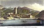
The bizarre, indented coast of Crimea attracts sailors and beachgoers with this particular feature. Numerous bays allow you to find both a convenient anchorage and a coastline that is not subject to the fury of the waves. The Kalamitsky Gulf of the Black Sea is not large, but its coasts are unique natural corners.
Where is Kalamitsky Bay located on the map?
It is located in Western Crimea. On its banks are Zaozernoye, and Saki, Novofedorovka, Nikolaevka and Beregovoye, Sandy and.
Geographic details and features
This is where the controversy begins. Classical - old - sources have always indicated that the gulf is limited by capes Evpatoria and. Thus, it occupies a significant part west coast Crimean peninsula. However, modern data "cut" these figures. In their opinion, the bay “does not reach” to Chersonesus, and its border is.
Give short description Gulf is easy. It is smaller than, juts out into the land slightly - by 13 km, but it has a wide entrance - according to modern data, 41 km. The depths are different, maximum 30 m, so even heavy ships are not in danger of running aground. The height of the coast rises from north to south. In the area of Cape Evpatoria, it is sloping, sandy, with extensive beaches. To the southern tip, the coast rises, near the ledge of Lucullus it is 15 m.
Near the Kalamitsky Bay there are several salt lakes:
- Yaly-Moynaksky (Big and Small),
- Saki,
- Bagails.
A hydrographic study proves that they should have once formed a section of the harbor, but were separated from it by overburdens literally a few meters wide. As a result, the properties of their filling and bottom silt have changed. These are often called firths.
Kalamitsky Bay in Crimea is considered a very clean water area of the Black Sea.  This is largely due to the fact that it is located far from the confluence. The rivers and the Western Bulganak flow directly into it, within its present-day boundaries, but they cannot create a strong suspension of the brought soil in it. The purity of the water explains not only the tourist attractiveness of the region, but also its natural wealth.
Mutually exclusive transfers
The region of Kalamitsky Bay has been giving philologists a lot of work for a long time. They have no way of ascertaining the origin and meaning of its name. Yes, everyone knows about the existence of the medieval one, but for some reason the fortification was also called that way! There are many mutually exclusive versions borrowed from different languages: “beautiful”, “good, comfortable cape” and even “misfortune, disaster”. The riddle, like so many different definitions, can be attributed to the same place.
Raises questions and the name "Lucullus". Many have heard about the existence of the Roman commander Lucullus, who loved to eat deliciously. He probably visited these parts, but the ledge of land still does not look like him. In fact, at first famous maps he was called in Tatar - Uluk-Kol. There is indeed a beam with that name (“long sleeve”) nearby. Probably later, the name, indigestible for the first Russian settlers, was changed into a more musical surname of a Roman military man.
Life and health protection
Since the Kalamita Bay is famous for its cleanliness, rest in these parts is especially beneficial for health. Estuary lakes (the most famous, but similarly used silt from others) are a source of healing mud used in the treatment of many diseases of the nervous system, skin, musculoskeletal system, and respiratory organs.  Clean air and water complement the healing effect.
It warms up relatively quickly. bathing season in favorable years, it lasts here from May to September. The beaches of Evpatoria enjoy good fame - sand is much more convenient for vacationers than pebbles. Many of them have a gentle entrance to the sea - this is one of the reasons why the city is especially recommended as a children's resort. The neighborhood is famous for its beautiful spacious beaches (the name speaks for itself). The small village is not as famous as Yevpatoria, but it is for the better - the prices are lower, and there is more space.
In addition to holidaymakers pure water liked marine life. In order to protect the system in which the sea interacts with the land, a reserve has been created at Cape Lucullus. Its coastal complex is recognized as a natural monument. vegetable and animal world here it is very rich, including rare species. Spring adonis (Adonis) grows here, steppe dyke, little bustard, steppe eagle, four-stripe snake, steppe viper are found.
Near Lucullus, archaeologists discovered the remains of a large settlement of the Scythian times. Conventionally, it is called Ust-Alminsky. So far, the archaeological site has not been identified from written information, but it is clear that it was a fairly large policy. This object requires an early study - a significant part of it has already been lost as a result of erosion by the sea.
How to get (get there)?
You can get to Kalamitsky Bay from any corner of the Crimea, buses in this direction are not uncommon from Simferopol, Yalta, Sevastopol, Feodosia and even Kerch.
We will show on the map how to get by car to, one of the very attractive ones here, from Simferopol:
Note to the tourist
- The address: Western Crimea, The Russian Federation.
- GPS coordinates: 45.002367, 33.566267.
Visitors should behave culturally so that the Kalamitsky Bay of Crimea and its Black Sea environs can help improve the health of guests and preserve the biological diversity of the region for a long time to come.
Echinoderms of the Black Sea
The mirror of the Black Sea has an area 422 thousand square kilometers.
Max Depth - 2210 m.
bowl of the sea holds 527 cubic kilometers of water.
The shape of the Black Sea resembles an oval with the largest axis of 1150 kilometers. The largest length from north to south is 580 kilometers, and the smallest is 265 kilometers.
Average depth of the Black Sea - 1240 m.
The Black Sea is located o in middle latitudes: 41 - 46 degrees north latitude.
In the Black Sea water salinity on average - 18, in the Sea of \u200b\u200bAzov - 4, in the Mediterranean Sea - oceanic salinity of water - 37 grams per 1 liter of water.
It is connected by the Bosporus and Dardanelles with the Marmara and mediterranean sea, the Kerch Strait with the Sea of Azov.
The only large peninsula in the Black Sea - Crimean.
Major bays: Yagorlytsky, Tendrovsky, Dzharylgachsky, Karkinitsky, Kalamitsky, Feodosia, Varna, Burgassky, Sinopsky, Samsunsky.
Total length of coastline - 3400 kilometers.
Islands in the Black Sea: the largest island - Dzharylgach - area 62 square kilometers. Other islands are smaller, the most significant: Berezan and Serpentine - both less than 1 square kilometer in area.
Feature of the Black Sea consists in the fact that at a depth of more than 150-200 meters, the habitat of anaerobic bacteria begins, the result of which is the release of hydrogen sulfide. Organisms that need oxygen cannot live there. Life develops only in the upper layer of the sea. This layer makes up 12 - 13 percent of the total volume of the sea, while containing 80 percent of the entire fauna of the Black Sea. This sea views, which penetrated here through the Bosphorus and brackish-water organisms, common in similar reservoirs throughout the planet. And fresh species appear from the rivers flowing into the Black Sea.
The Black Sea is poorer in species than the Mediterranean. But this is due to the special conditions of this reservoir.
Inhabit:
1. species that tolerate a wide range of water salinity.
2. types of this temperature regime - the water is moderately cold.
3. species that do not need great depths at any period of development.
All types of living beings can be divided into two large groups:
permanent and temporary.
2.5 thousand species of animals live in the Black Sea:
- 500 species - unicellular.
- 160 species - vertebrates (fish and mammals).
- 500 species - crustaceans.
- 200 species - molluscs.
- other invertebrates of different groups.
In the Mediterranean Sea, for comparison, there are about 9 thousand species of animals, and in the Sea of \u200b\u200bAzov - about 600 species.
Large mobile animals enter the Black Sea from the Mediterranean of their own accord. But a large number of species are constantly brought here, regardless of their desire, through the straits.
There are always two currents in the Bosphorus Strait:
1. Upper- carries desalinated water from the Black Sea to the Sea of Marmara and further to the Mediterranean Sea.
2. lower- delivers more salty and warm water to the Black Sea. With it (stream thickness 2-8 meters) planktonic organisms are brought into the sea. Live starfish, brittle stars, sea urchins have been found here.
The flora of the Black Sea includes:
- 270 species of green, brown, red bottom algae.
- 350 species of microscopic plankton.
- a variety of bacteria.
Most planktonic algae solar energy builds itself from simple compounds. Some algae, like animals, can only feed on ready-made organic substances. Algae noctiluca (night light) is a predator.
Material used for the article:
Encyclopedic Dictionary of Brockhaus and Efron: In 86 volumes - St. Petersburg, 1890-1907.
Agbunov M. V. Antique pilot of the Black Sea. Academy of Sciences of the USSR. Nauka, Moscow, 1987.
Kuzminskaya G. Black Sea. Krasnodar 1977.
Animals of the Black Sea. Simferopol: Tavria, 1996.
Wikipedia