Lake Ladoga: facts. Open left menu Lake Ladoga Lake Ladoga Ladoga
Ladoga lake- one of the largest fresh water bodies in Europe. In our article we want to talk about where the nature and climate are on its coast. It has quite interesting characteristics. The nature here is particularly beautiful.
Lake location
Where is Lake Ladoga located? It is partially located in Karelia (eastern and northern coast) and in Leningrad region(southern, southeast, west). On its banks there are cities such as Novaya Ladoga, Priozersk, Shlisselburg, Sortavala, Lakhdenpokhya, Pitkyaranta.
Lake Ladoga on the map is located both in the Leningrad region and in Karelia. It's big enough. In addition, there are also islands on it. The area of Lake Ladoga is 17.9 square kilometers excluding island areas. It extends from north to south for two hundred and nineteen kilometers. Its widest point is one hundred thirty-eight kilometers. Agree, the dimensions are impressive. Using these parameters, you can estimate the area of Lake Ladoga.
The depth of the reservoir in the northern region ranges from seventy to two hundred and thirty meters, and in the southern part from twenty to seventy meters. As you can see, the depth of Lake Ladoga is very heterogeneous, and is most important in the northern part of the reservoir. And the volume of water mass is nine hundred and eight cubic meters.
Rivers of Lake Ladoga and islands
Thirty-five rivers flow into the reservoir. But only one originates from it - the Neva. On the southern coast of the lake there are three large bays: Volkhovskaya, Svirskaya and Shlisselburgskaya Bay.

The most large river, flowing into Ladoga, is the Svir. She brings water to it Lake Onega. Rivers such as Avloga, Morye, Burnaya, Airajoki, Vidlitsa, Obzhanka, Syas, Olonka and others also flow into the reservoir.
It must be said that in Lake Ladoga the water level is not constant. It constantly fluctuates, and this is clearly visible from the white stripes on the rocks that go under the water.
The islands of Lake Ladoga are quite numerous. There are about 660 of them. Their total area is four hundred thirty-five square kilometers. It must be said that more than five hundred islands are located in the northern part of the reservoir. This is the Skerries region.
Largest islands:
- Riekkalansari - 55.3 km. sq.
- Mantsinsaari - 39.4 km. sq.
- Kilpola - 32.1 km. sq.
- Tulolansari - 30.3 km. sq.
- Vaalaam - 27.8 km. sq.
The most famous on the lake are the Valaam Islands. They are an archipelago of fifty islands with total area about thirty-six square kilometers. They became famous thanks to the Valaam Monastery, located on the main island, and the Nativity of the Mother of God Monastery on the island of Konevets.
History of the lake
Lake Ladoga is located in a basin that has a glacial tectonic origin. Three hundred to four hundred million years ago the entire territory of the lake and its basin was covered by the sea.

The modern relief was formed as a result of glacier activity. The main factor was the change in sea level and the rise of land. After the glacier retreated, the Baltic fresh water formed glacial lake. Later, the waters of this reservoir went to the territory of modern Switzerland. And there the Ioldian Sea was formed.
Nine and a half thousand years ago, Ancil Lake appeared due to the rise of land. On the Karelian Isthmus it was connected through a strait with Lake Ladoga. And eight and a half thousand years ago, ongoing tectonic processes opened the Danish straits, and the Littorina Sea was formed. This, in turn, led to the emergence of the Karelian Isthmus and, in fact, the formation of Lake Ladoga. Over the past two and a half thousand years, the relief in these places has hardly changed.
The northern part of the lake is located on the southern part - on the East European Platform. It is at the junction of these surfaces that the greatest depth of Lake Ladoga is observed.
Climatic conditions
Lake Ladoga has a temperate climate, sort of a transitional form from temperate maritime to temperate continental. Such climatic conditions are explained very simply. Geographical position Lake Ladoga and the atmospheric circulation of this region determined such a climate.

It must be said that in these places there are not many sunny days a year. This means that the amount of solar heat reaching the earth is not so great. Therefore, moisture evaporates extremely slowly. In 12 months there may be only sixty two here sunny days. For most of the year, this region is dominated by days with cloudy, cloudy weather and diffuse lighting.
It is better to plan your vacation on Lake Ladoga from the twenty-fifth of May to the seventeenth of July, then you can watch the white nights here. These days the sun does not go below the horizon, morning and evening twilight merge into a single whole. In general, white nights last about fifty days.
It should be noted that Lake Ladoga itself also influences the local climate, smoothing out extreme characteristics. Throughout the year, southwestern and western winds dominate here. Quiet and windless weather is extremely rare. Sometimes the winds are stormy.
The entire coast experiences breezes during summer days and nights. They start around nine in the morning and last until eight in the evening. Breezes penetrate fifteen kilometers inland. Fogs are observed here most often in spring, autumn and summer.
Lake shoreline
The coastline of Ladoga is more than a thousand kilometers long. The northern shores are heavily rugged rocks, forming many peninsulas and narrow bays, as well as small islands separated by straits.

The southern coastline is low. It is less rugged and is often flooded. The coastline is entirely covered with rocky reefs, banks, and shoals. Volkhovskaya, Svirskaya and Shlisselburgskaya bays are the most large bays Lake Ladoga.
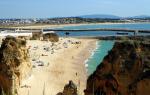
The eastern shores are very little indented. There are two bays here: Uksunlahti and Lunkulanlahti. It is in this part that there are wide, beautiful sand beaches.
The western shore of the reservoir is even less rugged. It was completely overgrown with dense mixed forests and shrubs, which came close to the water. The shore is strewn with scatterings of boulders. Stone ridges sometimes extend from the cape far into the depths of the lake, thereby forming dangerous shoals.
Relief of the lake bottom
As we noted earlier, the topography of the lake bottom is heterogeneous and has a clear increase in depth from south to north. We can say that the average depth of the reservoir is about fifty meters, and the greatest is two hundred and thirty-three meters (towards the north of the island of Valaam). Lake Ladoga in the northern part has a very uneven bottom. It is completely dotted with depressions. And in southern region the bottom is smoother and more even. Lake Ladoga is the eighth deepest lake in Russia.
The transparency of lake water varies on different shores. Its lowest indicators are observed in the Volkhov Bay, and the highest - in a western direction from the Valaam Islands.

During a strong storm, the water in the lake, as they say, boils and seethes, it is completely covered with foam.
Only the central part of the reservoir can be covered with ice and only in a very severe winter. A long cold period leads to a strong cooling of the water, for this reason the water in the lake remains cold even in summer. It only has time to warm up in the thin upper layer and narrow coastal strip. The maximum temperature of surface waters is in August, when it is twenty-four degrees. The water in the lake is fresh and, in principle, quite clean, except in those areas where there is runoff pollution from industrial waste.
Economic importance of the lake
The location of Lake Ladoga has determined its serious economic importance for the country. The fact is that the lake is navigable, which is important for the region. It is considered one of the parts of the waterway that is part of the Volga-Baltic Route, as well as the White Sea-Baltic Canal.
The most navigable is South part Ladoga from the Neva to the Svir. Since the reservoir is quite large, there are often storms, especially in the fall. During such periods, all shipping is stopped for the safety of passenger ships.
Since the founding of St. Petersburg, the lake has become part of the unified water transport system of northern Russia. For safe navigation along south coast The Staraya Ladoga Canal was built. As soon as it was not enough, the Novoladozhsky Canal, one hundred and sixty-nine kilometers long, was also laid.

The Staraya Ladoga Canal is now almost completely dry and overgrown. And the second canal is still navigable. Up to eight million tons of cargo are transported across the lake every year. Petroleum products, chemical raw materials, building materials, and timber are transported to the Baltic from the Volga. In addition, tens of thousands of passengers are transported across Ladoga every year.
From Moscow, St. Petersburg and other cities there are cruises (tourist) to the islands of Konevets and Valaam. Vessels enter and pass through the central waters of the lake, where the shores are not visible. And in strong winds you can feel significant rolling.
Regular passenger transportation in Ladoga no. However, tourist ships sail twice a day to certain destinations during navigation periods.
Fish living in the waters of the lake
The fish of Lake Ladoga is of industrial importance. Ten species are caught, among which the most popular are vendace, smelt, and ripus. There are quite a lot of pike perch and whitefish in the lake.
Holidays on Ladoga
Despite the fact that the water in Lake Ladoga remains cold even in summer period, it attracts a large number of vacationers. As we said earlier, there are beautiful sandy beaches on the coast. The northern islands are especially popular among tourists. The best period for kayaking on the lake is June and July. A little closer to autumn, storms begin, during which the water is rough, like in the sea.
Here on the lake there is Nizhnesvirsky nature reserve. It is located on the right bank of the Conservation Area - a wetland of international importance. They are interesting because they are a nesting site for aquatic and migratory birds. 256 different species of birds have been recorded in this area.
The island of Valaam is of particular interest to tourists. It is completely covered with coniferous forest. There is an ancient one on the island monastery, which was founded in the ninth to eleventh centuries.
Vacationers also like to visit Konevsky Island, which has a monastery. The island received this name from the Horse-Stone boulder located here. Until the end of the nineteenth century, this stone was a place of sacrifice. The main attraction is the Church of the Nativity of the Blessed Virgin Mary, located on the territory of the monastery.
Historical excursion
The Novgorodians had a military and merchant fleet on Lake Ladoga for several centuries in a row. Geographical information came to Western cartographers in those days. Lake Ladoga appeared on the map of the Moscow state back in 1544. It was made by the German scientist Sebastian Munster.
And in 1600, a drawing of Rus' was drawn up by Fyodor Godunov. The lake was depicted on it with fairly high accuracy. In the middle of the eighteenth century, a map was made not only of Lake Ladoga itself, but also of an artificial canal.
Novaya Ladoga
Novaya Ladoga is one of the towns on the shore of Ladoga. It is located on the left side of the Volkhov River in the place where it flows into the lake. The city was founded in 1704 by Emperor Peter the Great himself. A large number of historical architectural monuments, which may be of interest to guests and tourists.
Shlisselburg
The city is located on the shore of Ladoga. It was founded by the Prince of Novgorod in 1323, who founded a wooden fortress on the island of Oreshek. It was later captured by the Swedes, who renamed it Noteburg. And in 1702 the fortress was recaptured by Peter the Great. That's what he gave her current name. The city also has its own attractions: the Staraya Ladoga Canal, the Oreshek fortress, the monument to Peter the Great, the Annunciation Cathedral, St. Nicholas Church.
Priozersk
A Karelian settlement lived on this site already in the twelfth century. And in 1310, the Novgorodians built a capital fortress at the mouth, called Korela. Later it was conquered by the Swedes. But in 1710 it again passed to the Russian Empire.

Lake Ladoga and its surroundings - enough interesting places for tourists. Here you can not only admire the beauty of nature, take boat trips, visit the islands, but also see historical monuments, preserved to this day.
Lake Ladoga is located in the Republic of Karelia and the Leningrad region of the Russian Federation. It is considered one of the largest freshwater lakes in Europe. Its area is about 18 thousand square meters. kilometers. The bottom is uneven: in one place the depth can be 20 meters, and in another - 70 meters, but the maximum is 230 meters. 35 rivers flow into this water area, and only the Neva flows out. The Ladoga region is divided into Northern and Southern, Eastern and Western.
Formation of the water area
Scientists say that Lake Ladoga is of glacial-tectonic origin. On the site of its basin, approximately 300-400 million years ago, there was a sea. The change in relief was influenced by glaciers, which led to the rise of the land. When the glacier began to retreat, a glacial lake with fresh water appeared, Ancylovoe Lake appeared, which connected with Ladoga. New tectonic processes took place 8.5 thousand years ago, due to which the Karelian Isthmus was formed and the lake became isolated. Over the past 2.5 thousand years, the relief has not changed.
In the Middle Ages in Rus' the lake was called “Nevo”, and in Scandinavia – “Aldoga”. However, its real name comes from Ladoga (city). Now this is the name of not only the city, but also the river and lake. It is difficult to determine which particular object was first named Ladoga.
Climatic features
In the area of Lake Ladoga, a temperate and transitional climate has formed: from continental to maritime. It depends on the circulation of air masses and on the location. The amount of solar radiation here is small, so moisture evaporates slowly. The average number of days per year is 62. The weather is mostly cloudy and cloudy. The duration of daylight hours at different times of the year varies from 5 hours 51 minutes. until 18:50 From the end of May to mid-July there are “white nights”, when the sun sets below the horizon at about 9°, and the evening smoothly turns into morning.
The water resources of the lake are the main climate-forming factor in the Ladoga region. The water area helps smooth out some climate indicators. Thus, air masses from the continent, passing over the surface of the lake, become sea masses. The minimum atmospheric temperature drops to -8.8 degrees Celsius, and the maximum rises to +16.3 degrees, the average is +3.2 degrees. The average annual precipitation is 475 millimeters.
Recreational wealth
Despite the fact that even in summer the water in the lake is very cold, a large number of people come here on vacation every year, so there are beaches for tourists. Many vacationers go on catamarans and kayaks.
There are 660 islands on the lake, and they are mainly concentrated in the northern part of the reservoir. Among the largest are the Western and Valaam archipelagos, and largest islands– Riekkalansari, Valaam, Mantsinsaari, Tulolansari, Kilpola. On some islands, monasteries were built (Konevei, Valaam), where the relics of saints rest and sacred relics are located. There is also a memorial “Road of Life”.
On the territory of the Ladoga basin there is the Nizhnevirsky Nature Reserve, home to various species of fauna, including rare ones. These types of flora grow here.
And meridians 29°48 and 32°58` east longitude from Grinich. With an oval shape, somewhat pointed to the north, the lake stretches almost along the meridian, along which it has the greatest length of 196.5 kilometers. The greatest width of the lake is almost in the middle of its length, at the parallel of 61° north latitude, and between the mouths of Vuoksa and Olonka, 124 kilometers.
To the north, the shores of the lake quickly narrow and end in the Hien-Selke Bay, and to the south, the shores narrow slowly and end in the vast Shlisselburg and Volkhov bays, separated by a wide ledge. Length coastline 1071 km, of which 460 km, occupying part of the western bank, from the border with the Polutorny stream to the source of the Neva, the entire southern bank and part of the eastern bank to the village of Pogranichnye Konduzhi, belong to Russia, the remaining 610 km. belong to Finland.
The surface of the lake, including the islands, is 15923 km2, of which 8881.1 km2 in Russia and 7041.6 km2 in Finland, second in size big lakes and America, Lake Ladoga is significantly larger than all European lakes: it is twice as large, three times as large as Venus, five times as large and ten times as large as Saimaa, not to mention the rest of the Western European lakes.
Lake Ladoga serves as a receiver for a huge amount of water, the only one of which is the high-water Neva, flowing from the southwestern corner of the lake in two branches, separated by Orekhov Island, and flowing into St. Petersburg. Of the tributaries directly flowing into Lake Ladoga, the following are remarkable: in the western part of the lake: the Vuoksa River, flowing from Lake Saimaa and forming famous waterfall Imatru, flows into Lake Ladoga partly directly at Kexholm, partly through Lake Suvanto by the Taipala River; in the northern part: Gellul, Lyaskil, Uksu, Tuloma, and Minol; in the eastern part: Vidlitsa, Tuloksa, Olonka, Obzha, Svir with Oyat and Pasha and Voronega; in the southern part: Sias with Tikhvinka, Volkhov, Kobona, Lava, Sheldikha and Nazya. The tributaries of the Volkhov, Syas and Svir serve as the beginning of three water systems: Vyshnevolotskaya, Tikhvinskaya and Mariinskaya, connecting Lake Ladoga with the Volga basin, and each of the named rivers, together with the rest of the southern rivers, when they flow into the lake, is connected or intersected by old and new bypasses Ladoga canals, which stretch along the entire southern and often eastern shore of the lake, from the source of the Neva to the mouth of the Svir.
With the help of its numerous tributaries, Lake Ladoga covers, in addition to parts of Finland, St. Petersburg and Olonets, almost all of the Novgorod and some parts of the Pskov, Vitebsk, Tver and Arkhangelsk regions. Ladoga basin contains a space of 250280.3 km2 Although Lake Ladoga, being between the basin and and, occupies quite advantageous position, and in terms of its vastness, depth and excellent navigation conditions, it itself constitutes an inland sea, but its navigation and trade and economic significance seem extremely insignificant, due to the bypass Ladoga canals, which made the construction of sea-type vessels necessary for navigation in the lake completely unnecessary.

Bay, Lake Ladoga and rocks (photo by Oleg Semenenko)
Shores of Lake Ladoga. From the mouth of the Vuoksa to the source of the Neva, the coast consists of clay and loamy sediments, bordered by sandy soil, with numerous boulders. Up to the mouth of Taipala, the coast is still quite elevated, but further to the south there is a low-lying desert coast, partly sandy and partly covered with thick grass. The southern shore of the lake, between the source of the Neva and the mouth of the Svir, is low-lying, almost treeless and consists of clayey and swampy soil; formed by sediment from rivers flowing into the lake, it is bounded from the south by an elevated ridge of limestones of the Silurian system, which, in all likelihood, was once the shore of Lake Ladoga. Currently, they are located at a distance of 3 to 30 kilometers from it, and only near the mouth of the Svir the limestones with their rocky cliffs cut like a wedge into the shore of the lake, towards Cape Storozhensky, forming the outskirts of a peninsula that protrudes far into the lake.
Eastern coast, from the mouth of the Svir to lake. Karkun-lamba, at first low-lying and partly swampy, gradually rises and consists of clayey and loamy soil, which on the very coastline turns into purely sandy. The coastal area of the northwestern part of the lake is in complete contrast to the southeastern part. Here the shores and those adjacent to them are elevated, rocky and consist mainly of granite, partly gneiss, syenite and other crystalline rocks, as well as various types of marble.
From Kexholm to the north and further east to Impilax, the granite gradually changes from light gray and coarse-grained to bluish-gray and fine-grained, very strong and hard, then, to Pitkerando, it turns reddish, but south of Pitkerando the granite completely disappears from the surface land, and the soil is sandy-clayey, filled with boulders of various types, and granite is found only in low-lying capes protruding into the lake, consisting of fine-grained red granite.
Islands in their composition and height they correspond to the shore near which they are located. Almost all the islands in the northern part of the lake are elevated, consisting mainly of granite and hard rock, while the islands in the southern part are low-lying, partly marshy and surrounded by shallows and reefs. Thanks to the many islands and significant ruggedness of the shores, the northern part of the lake is very rich in bays and bays sheltered from the winds, which represent very comfortable places for a quiet anchorage of ships, but in the southern part of the lake there are almost no such places with almost everything, as a result of which here ships, in strong winds, are forced to settle in open lake, mainly in the open and dangerous Koshkinsky roadstead.
Of the islands in the northern part of the lake, near the shores, the most remarkable are: the island of Kuko-sari, lying at the mouth of the Vuoksi River. In the Kronober Bay: Kilpodan, Korpan and Teposari, the last two of which form the entrance to the bay, which is a vast bay, completely calm for ships. The island of Sarolin, which makes up the left shore of Yakimvar Bay, is 12 km away. jutting out into the mainland and representing a safe bay with all sorts of conditions.
Of the islands in the middle of the northern part of the lake, the following stand out: the Valaam group, consisting of 40 islands that stretch parallel, at a distance of about 20 km. from the extreme islands of the northern skerries. The main and largest of this group is the island of Valaam (26.2 km2), which has a very irregular shape, but with the closely adjacent islands of Skitsky, Predtechensky and Nikonovsky, it appears in the form of an equilateral triangle. In its northwestern part, on a rock, the Valaam-Preobrazhensky Monastery is located, in the depths of the bay, with a convenient pier. To the east of Valaam stretch the islands: Baiovye and Krestovye. To the southwest of the island: Gange-pa with a lighthouse, Muarka, Yalaya and Rahma-sari, lying almost on the same parallel. To the south are the islands: Suri Verko-sari and Voschaty or Vasiya-sari. South of this last island lies Konevets (6.5 km2), on which the Konevsky-Rozhdestvensky Monastery is located.

Lake Ladoga (photo by Dmitry Savin)
Depth Lake Ladoga is generally quite significant; distributed unevenly, depending on the height of the banks: the steeper and more elevated the shores adjacent to the water's edge, the greater the depth and vice versa. From the southern low-lying shore, the depth, starting from half a meter, slowly and gradually increases; having passed the reefs and shoals protruding from this shore, it begins to quickly increase, so that in the middle of the lake it is from 60 to 110 m, further to the north it increases to 140, and in some places reaches 200 meters. Thus, the Ladoga bottom has a very significant slope from south to north, and it consists of a number of more or less irregular ledges, on which in some places there are significant mounds and hills, in places there are depressions and basins. Thus, between the lines of equal depths of 60 and 80 m, there are bottom elevations at which the depth is only 32 m, and in the northwestern part of the lake, between the lines of equal depths of 10 and 140 m, there are depths of 200 or more m.
Water level and currents. The water level of Lake Ladoga is subject to constant fluctuations, depending on the totality of all meteorological circumstances in the entire basin of the lake, as a result of which the height of lake water not only in different years, but also at different times of the same year can be very different. Since time immemorial, the existing belief about the seven-year periodicity of changes in the lake water level, according to which the lake water horizon constantly seems to rise for 7 years, and constantly decreases over the next 7 years, was completely refuted by 14-year observations, which were produced on the island of Valaam and of which there was no correctness in changing the position of the water level.
Opening and freezing. First of all, it is covered thin ice shallow southern part of the lake, usually in early November, sometimes at the end of October, at a temperature of about 5 degrees Celsius. This thin ice or lard is carried by the current into the Neva, where the autumn ice drift begins and does not last long. In the lake itself, with increasing frosts, the entire southern part of the lake is covered with ice, both at the very shore and in the space between the reefs and shoals protruding from it. Further, to the north of the parallel of the Sukhsky lighthouse, under the influence of winds that easily break up the formed ice, the lake does not freeze for a long time, and at great depths in the northern part it freezes only in December, often in January, in other years the middle of the lake remains unfrozen all winter .
In general the lake is covered solid ice Only in the harshest winters, during ordinary frosts only the outskirts, 20-30 kilometers from the coast, are covered with ice. Determining whether the middle of the lake is frozen or not seems to be quite difficult, due to the distance of the middle of the lake from the shore. Fishermen who carry out ice seine fishing determine this with great accuracy by the current in the ice holes: if in the ice holes there is a current corresponding to the direction of the wind, then the middle of the lake remains unfrozen, but the absence of a current shows that the entire lake is covered with solid ice.
The opening of Lake Ladoga, like freezing, also begins at the southern shore of the lake, usually at the end of March - the first half of April, simultaneously with the opening of the southern tributaries and warm water, which has a direct impact on the opening of the Neva, which always begins from the source, at Shlisselburg, and two ice drifts occur on it: the river itself, which does not last long, and the very long Ladoga ice drift, which almost never passes at once.
Lake Ladoga - the largest freshwater lake in Europe - is located in the north-west of Russia, in a harsh region with majestic nature and rich history. It was here that Russian statehood was born and the first Russian cities appeared.
The history of the lake, the unique and rich nature - all this makes Lake Ladoga a most valuable cultural object and a beautiful corner of Russia.
Origin of the lake
The lake was formed by the melting of a glacier, and this process lasted several thousand years. Several times the giant lake either merged with the waters of the ancient ocean, or again found itself surrounded by the firmament. Finally, about three thousand years ago, a body of water, pressed by its banks, broke through to Baltic Sea the Neva River.
The gradual formation of the lake was reflected in the unique bottom topography: if in the northern part of the lake the depth reaches 230 m, then in the “shallow” southern part it is 20-70 m. The difference in landscape is also explained by the fact that the reservoir belongs to different natural areas. The Karelian (northern) coast lies on the Baltic crystalline shield, it is steep and rocky. South coast, located in the Leningrad region, consists of sedimentary rocks. The coast gently goes under the water, forming sandbanks and beaches.
Lake Ladoga on the map looks like the footprint of some giant beast. The length of the reservoir from north to south is 219 km, and from west to east – 138 km. The huge area of the lake is over 18,000 square meters. km – holds about 900 cubic meters. km of water. More than 40 rivers and streams fill it with their waters, and only one - the deep Neva - flows out. Some rivers connect Lake Ladoga with other lakes - Onega, Ilmen, Saimaa.

There are many islands on the lake - more than 660. In the north of the lake are the famous Ladoga skerries - a magnificent necklace of a series of rocky islands separated by narrow straits. Main Diamond this stunning natural phenomenon with its unique beauty is the holy island of Valaam with the famous Spaso-Preobrazhensky Monastery.
History of the lake
Lake Ladoga occupies a special place in the history of our country. The name of the reservoir comes from the name of the ancient Russian city of Ladoga, but there is another version: on the contrary, the city is named after the lake. Until the 13th century, the lake was called “Great Lake Nevo.” In Finnish, the word “nevo” means “swamp”, “quagmire”.
 Fateful events reflected in culture and history are associated with Lake Ladoga:
- the famous route from the Varangians to the Greeks passed through Ladoga;
- in the 14th century, Oreshek, the oldest Russian fortress, was built at the sources of the Neva;
- at the end of the 14th century, the largest Orthodox monasteries were built on the islands - Valaam and Konevsky, famous for their missionary activities;
- Novgorodians kept a navy here;
- battles of the Northern War of 1701-1721 took place on the lake and its shores;
- The road of life during the Second World War.
Since 1721, the coast of Lake Ladoga became completely Russian. Even then, Peter I appreciated the harsh nature of the lake, its treachery: complete calm in a few tens of minutes can give way to a real storm, and the waves rise to a height of 4-5 meters. Such inconstancy of the lake forced the Russian emperor to say the famous words that only the one who walked on Ladoga can be considered a real sailor.
The road of life
The history of the lake has tragic pages that evoke tears of joy and grief at the same time - this is a heroic chronicle of the salvation of hundreds of thousands of human lives from besieged Leningrad during the Great Patriotic War.
The road of life across Lake Ladoga connected the dying city with the country and saved it from death. Between September 1941 and March 1944, 1,600 thousand tons of various cargo were transported across the water and ice of the lake and more than 1,300 thousand people were evacuated.

In winter, goods and people were transported on the famous “one and a half trucks” - GAZ-AA. With the melting of the ice, navigation by water began. In addition to 15 barges, metal ships took part in navigation, the construction of which was carried out in Leningrad.
The road of life passed near the front line and needed protection. It was defended by anti-aircraft artillery divisions and fighter regiments, but thin ice and bombing destroyed about a thousand trucks.
In memory of the feat of the Soviet people on the Road of Life, 7 monuments, 112 memorial pillars along the highway and railway. The most famous of the monuments is “The Broken Ring” by architect V. G. Filippov. 
Why you need to visit Lake Ladoga
Ladoga is one of the many water bodies in our country, visiting which will bring great pleasure. From year to year, in any season, thousands of fishermen, pilgrims and simply vacationers flock to the shores of the lake. Each of them has their own interests, but no one is left indifferent by the stunning beauty of the water surface, quaint islands, majestic shores and, of course, the harsh character of the lake. You need to make friends with him, and then your relationship with the lake will last for many years, bringing a lot of impressions.

So why is it worth visiting the shores? wonderful lake? Here are probably the main reasons:
- . The lake is home to over 50 species of fish, the most famous of which are salmon, whitefish, Ladoga smelt, and pike perch. You can fish at any time of the year with consistently excellent results.
- Rich flora and fauna. The nature of Lake Ladoga is unique and diverse: here you can find southern plant species and tundra flora; Hares, wolves, bears, moose and other species of animals live in the forests, and the Ladoga seal lives in the north of the lake.
- Diving. Thanks to the fresh and clean water, its low temperature, the artifacts of bygone times lying on the bottom are perfectly preserved and are of scientific and research interest.
- Curious natural phenomena: mirages, brontides (underground rumble).
- Visiting holy places.
- Developed tourist infrastructure.
- Relax on sandy beaches.
- Complete absence of mosquitoes.

Lake Ladoga - mysterious, majestic and beautiful, will always attract thousands of tourists eager to experience its harsh beauty. The wealth of waters and shores, the bizarre landscape and history of the lake stuns the imagination and fills hearts with love for Russia, its nature and culture.
Lake Ladoga is the largest freshwater lake in Europe. Located on the territory of Karelia and the Leningrad region.
The first name of the lake was different. In ancient Russian chronicles it was called Nevo. Scientists believe that the name comes from the Finnish word for “swamp, quagmire.” In treaties concluded with Hanseatic cities and in the Scandinavian sagas it is called Aldoga, from the Finnish “wave”. Modern name came into use only from the beginning of the 13th century. The lake began to be called Ladoga, forming the name from the name of the city of Ladoga.
Scientists have proven that the basin of Lake Ladoga is of glacial-tectonic origin. In the Paleozoic era, the waters of the ancient sea splashed here; later, a glacier formed in this place, which largely shaped the modern topography of the reservoir and its surroundings. The area of the lake is 18,400 square kilometers. Its length from south to north is about 219 km. The maximum width of the reservoir (from west to east) is 138 km.
Due to its origin, Ladoga is characterized by uneven depths. The “shallowest” part of the lake is the southern one. Local depths do not exceed 70 m. But in the northern part, the average depth of Lake Ladoga is about 100 m. There are places where the water thickness reaches 260 m.
There is a noticeable pattern on Lake Ladoga: the steeper the shores, the great depths are located near them. The highest and steepest banks are in the north, directly next to the skerries. In the south they are flatter and the depths there are shallow.
By the way, the peculiarity of Ladoga is the uneven water level. In the old days they said that it grows for seven years and falls for seven years. On average, the lake's water reserves are 908 cubic kilometers. For comparison, Baikal is 24,000 km³.
32 rivers flow into Lake Ladoga, and only one flows out of it - the Neva. Many rivers connect Ladoga with other lakes. Through the Volkhov it is connected to Lake Ilmen, through the Svir River - to Onega, through Vidlitsa - to Vedlozero, through Tulema - to Tulmozero.

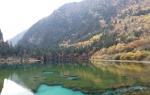
Sunset on Svir. The Svir River connects Lakes Ladoga and Onega.
The lake is rich in islands. Most of them are in the north. These are the famous Ladoga skerries, a beautiful necklace of islands that are separated from each other by a whimsical labyrinth of straits. An integral part of the Ladoga skerries is the famous Valaam archipelago, where the ancient Spaso-Preobrazhensky Monastery is located.
Among the large northern islands include Lunkulansaari, Konevets, Mantinsaari, Vossinansaari and others. In the southern part of the reservoir there are very few islands and they are all small: Ptinov in the Volkhov Bay and Zelentsy in Shlisselburg Bay.

On the shore of Lake Ladoga.
The unique inhabitant of the lake is the Ladoga seal. This is the only species of marine mammal that has adapted to life in fresh water. Their rookeries on the islands of the Valaam archipelago are under special protection.
From the end of the eighth century, Slavic settlements appeared on the shore of the lake: the city of Ladoga, later Korela, present-day Priozersk. At the beginning of the 14th century, the Oreshek fortress, present-day Shlisselburg, was built at the source of the Neva. The famous monasteries on Valaam and Konevets were founded a little later.

Shore of Lake Ladoga.
At the end of the 17th century, the southern, northern and west coast Lake Ladoga was transferred to Swedish Ingria. The Swedes rename the Russian Oreshek and Korela to Noteburg and Kexholm, and found the settlement of Sortavala. With the outbreak of the Northern War, Lake Ladoga becomes an arena of military operations. The most famous battles of that period were the battle of ships near Kexholm and the capture of Noteburg. In 1721, the Ladoga coast again became Russian.
Lake Ladoga is rich in interesting places:
Ladoga skerries
Skerries are rocky islands separated by narrow straits and channels. They occupy a significant part of the northern part of the lake. The skerries stretch in a semicircle from the city of Pitkyaranta to the village of Berezovo. Throughout their entire length they are stunningly beautiful, but the most majestic landscapes begin to the northeast of the island of Koinosaari, which closes the village of Terva from the expanses of Ladoga.
On the northern coast of Lake Ladoga there is amazing city Sortavala. It owes its unique historical and cultural appearance to three states at once: Finland, Sweden and Russia, of which it was a part at different times. This is a beautiful Karelian city, surprising with its unusual architecture.

Eastern Beaches
The eastern coast of Ladoga is famous for its clean sandy beaches. Shallow water warms up well, especially if June and May are warm. These beaches are considered ideal place for relax.
Lake Ladoga in these places seems endless, and on the coast in some places you can see sand dunes. There are also some near the village of Vidlitsy. The ancient settlement is located at the mouth of the river of the same name. In the village you can admire the Church of the Great Martyr George. The surroundings of Vidlitsa attract with incredibly beautiful nature.

Beach in the Vidlitsa area.
Priozersk
Ancient Korela, modern Priozersk, is one of the ancient Russian cities with an unusually interesting history. This is a beautiful town where ancient Orthodox churches and a majestic Lutheran church have been preserved. Here stands a unique ancient fortress. Pearls of architecture are surrounded by beautiful landscapes with picturesque rivers and dense northern forests.

Fortress Oreshek
The Shlisselburg fortress Oreshek is rightfully considered a historical and architectural monument. Built at the beginning of the 14th century on Orekhovoy Island, it served as an outpost on the Swedish border. The citadel has withstood fierce assaults more than once, fully justifying its name. Later, the fortress became the “Russian Bastille”, where the most dangerous criminals were sent. Today there is a museum here, which operates despite restoration work that has been ongoing since 1966.
Balaam
An archipelago consisting of fifty islands, the largest of which is Valaam. This is one of the most important shrines of Orthodoxy, Northern Athos, as it is called. Here is the oldest monastery in Russia. The history of its origin goes back to the 1st century, when Valaam was visited by Andrew the First-Called. Almost a thousand years later, the first monks came to the island from Novgorod. Valaam - unique place. It's all around here wild nature, practically unchanged since the development of the island by man.

Stormy waves of Lake Ladoga, which in windy weather looks like a sea, incredible sunsets and sunrises, sheer cliffs skerries and sand dunes of the eastern beaches. All this remains forever in the heart of everyone who has ever seen these magnificent landscapes. It’s worth coming here, because harsh Ladoga is not only living history, but also one of most beautiful places Russia.
Lake Ladoga on the map.
- Ladoga skerries;
- Sortavala;
- Priozersk;
- Balaam;
- Oreshek Fortress;
- Beaches on east coast lakes;
- Mouth of the Svir River.
Petrozavodsk, Kivach, Martialnye Vody, northern Ladoga, Ruskeala Waterfalls, Valaam and much more. Car and pedestrian travel for every taste - choose, and you will dream of Karelia for a very long time!