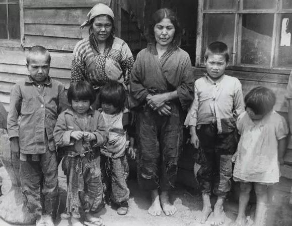
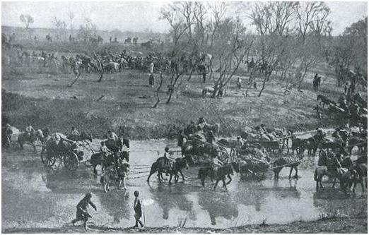
Kuril population. Kurile Islands
Territorial disputes also exist in the modern world. Only the Asia-Pacific region has a few of these. The most serious of these is the territorial debate for Kurile Islands... Russia and Japan are its main participants. The situation on the islands, which are considered to be of a kind between these states, looks like a dormant volcano. No one knows when he will begin his "eruption".
Discovery of the Kuril Islands
The archipelago, located on the border between the Pacific Ocean, is the Kuril Islands. It stretches from about. Hokkaido to The territory of the Kuril Islands consists of 30 large areas of land, surrounded on all sides by the waters of the sea and ocean, and a large number of small ones.
The first expedition from Europe, which ended up near the shores of the Kuriles and Sakhalin, was the Dutch navigators under the leadership of M. G. Fries. This event took place in 1634. They not only discovered these lands, but also declared them as Dutch territory.
The explorers of the Russian Empire also studied Sakhalin and the Kuril Islands:
- 1646 - discovery of the northwestern Sakhalin coast by the expedition of V.D. Poyarkov;
- 1697 - V.V. Atlasov becomes aware of the existence of the islands.
At the same time on southern islands Japanese sailors begin to sail in the archipelago. By the end of the 18th century, the appearance of their trading posts and fishing trips was observed here, and a little later - scientific expeditions. M. Tokunai and M. Rinzo play a special role in research. Around the same time, an expedition from France and England appears on the Kuril Islands.
Island discovery problem
The history of the Kuril Islands has still preserved discussions over the issue of their discovery. The Japanese claim that they were the first to find these lands in 1644. National Museum Japanese history carefully keeps a map of that time, on which the corresponding designations are applied. According to them, the Russian people appeared there a little later, in 1711. In addition, the Russian map of this area, dated 1721, designates it as the "Japanese Islands". That is, Japan was the discoverer of these lands.
The Kuril Islands in Russian history were first mentioned in the reporting document of Nikolai Kolobov to Tsar Alexei dated 1646 about the peculiarities of wanderings. Also, the data from the chronicles and maps of medieval Holland, Scandinavia and Germany testify to the indigenous Russian villages.

By the end of the 18th century, their official annexation to the Russian lands took place, and the population of the Kuril Islands acquired Russian citizenship. At the same time, state taxes began to be collected here. But neither then, nor a little later, no bilateral Russian-Japanese treaty or international agreement was signed that would secure Russia's rights to these islands. Moreover, their southern part was not under the rule and control of the Russians.
Kuril Islands and relations between Russia and Japan
The history of the Kuril Islands in the early 1840s is characterized by the intensification of British, American and French expeditions to the Pacific Northwest. This is due to a new surge of Russia's interest in establishing relations with the Japanese side, which have a diplomatic and commercial character. Vice-Admiral E.V. Putyatin in 1843 initiated the idea of equipment new expedition to Japanese and Chinese territories. But it was rejected by Nicholas I.
Later, in 1844, he was supported by I.F.Kruzenshtern. But this did not receive the support of the emperor.
During this period, the Russian-American company took active steps to establish good relations with the neighboring country.
The first agreement between Japan and Russia
The problem of the Kuril Islands was resolved in 1855, when Japan and Russia signed the first treaty. Before that, a rather lengthy negotiation process took place. It began with the arrival of Putyatin to Shimoda in the late autumn of 1854. But negotiations were soon interrupted by an intense earthquake. A rather serious complication was the support that the French and English rulers provided to the Turks.
The main provisions of the agreement:
- the establishment of diplomatic ties between these countries;
- protection and patronage, as well as ensuring the inviolability of the property of subjects of one state on the territory of another;
- drawing the border between the states, located near the islands of Urup and Iturup of the Kuril archipelago (preservation of the indivisible);
- opening of some ports for Russian seafarers, permission to conduct trade here under the supervision of local officials;
- the appointment of a Russian consul in one of these ports;
- granting the right of extraterritoriality;
- Russia's obtaining the status of the most favored nation.
Japan also received permission from Russia to trade in the port of Korsakov on Sakhalin for 10 years. The country's consulate was established here. At the same time, any trade and customs duties were excluded.
Relationship of countries to the Treaty
A new stage, which includes the history of the Kuril Islands, is the signing of the Russian-Japanese treaty of 1875. It caused mixed reviews from representatives of these countries. The citizens of Japan believed that the government of the country did the wrong thing, exchanging Sakhalin for "an insignificant ridge of pebbles" (as they called the Kuriles).

Others simply put forward statements about the exchange of one territory of the country for another. Most of them were inclined to think that sooner or later the day will come when the war will come to the Kuril Islands. The dispute between Russia and Japan will escalate into hostilities, and battles will begin between the two countries.
The Russian side assessed the situation in a similar way. Most of the representatives of this state believed that the entire territory belonged to them as discoverers. Therefore, the treaty of 1875 did not become the act that once and for all determined the delimitation between the countries. It also failed to be a means of preventing further conflicts between them.
Russo-Japanese war
The history of the Kuril Islands continues, and the next impetus to the complication of Russian-Japanese relations was the war. It took place despite the existence of treaties concluded between these states. In 1904, Japan's treacherous attack on Russian territory took place. This happened before hostilities were officially announced.
The Japanese fleet attacked the Russian ships that were in the outer roadstead of Port Artois. Thus, part of the most powerful ships belonging to the Russian squadron was disabled.
The most significant events of 1905:
- the largest land battle of Mukden in the history of mankind at that time, which took place on February 5-24 and ended with the withdrawal of the Russian army;
- Tsushima battle at the end of May, which ended with the destruction of the Russian Baltic squadron.
Despite the fact that the course of events in this war was developing in the best possible way in Japan's favor, she was forced to agree to peace negotiations. This was due to the fact that the country's economy was very depleted by military events. On August 9, a peace conference between the participants in the war began in Portsmouth.
Reasons for Russia's defeat in the war
Despite the fact that the conclusion of the peace treaty determined to some extent the position in which the Kuril Islands were, the dispute between Russia and Japan did not end. This caused a significant number of protests in Tokyo, but the consequences of the war were very tangible for the country.
In the course of this conflict, the practical complete destruction of the Russian Pacific Fleet took place, more than 100 thousand of its soldiers were killed. The expansion of the Russian state to the East also stopped. The results of the war were indisputable evidence of how weak the tsarist policy was.
This was one of the main reasons for revolutionary action in 1905-1907.
The most important reasons for the defeat of Russia in the war of 1904-1905.
- Diplomatic isolation Russian Empire.
- The absolute unpreparedness of the country's troops to conduct military operations in difficult situations.
- Shameless betrayal of domestic stakeholders and the mediocrity of the majority of Russian generals.
- The high level of development and preparedness of the military and economic spheres of Japan.
Until our time, the unresolved issue of the Kuril issue poses a great danger. After the Second World War, a peace treaty was never signed following its results. From this dispute, the Russian people, like the population of the Kuril Islands, have absolutely no benefit. Moreover, this state of affairs contributes to the generation of hostility between countries. It is the speedy solution of such a diplomatic issue as the problem of the Kuril Islands that is the guarantee of good neighborly relations between Russia and Japan.
Everyone knows about Japan's claims to the South Kuriles, but not everyone knows in detail the history of the Kuril Islands and their role in Russian-Japanese relations. This is what this article will be about.
Everyone knows about Japan's claims to the South Kuriles, but not everyone knows in detail the history of the Kuril Islands and their role in Russian-Japanese relations. This is what this article will be about.
Before moving on to the history of the issue, it is worth telling why the South Kuriles are so important for Russia *.
1. Strategic location. It is in the non-freezing deep-water straits between the South Kuril Islands that submarines can enter the Pacific Ocean underwater at any time of the year.
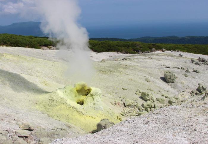
2. Iturup is home to the world's largest deposit of the rare metal rhenium, which is used in superalloys for space and aviation technology. The world production of rhenium in 2006 was 40 tons, while the Kudryavy volcano emits 20 tons of rhenium every year. This is the only place in the world where rhenium is found in its pure form, and not in the form of impurities. 1 kg of rhenium, depending on the purity, costs from 1000 to 10 thousand dollars. There is no other rhenium deposit in Russia (in Soviet times, rhenium was mined in Kazakhstan).
3. The reserves of other mineral resources of the Southern Kuriles are: hydrocarbons - about 2 billion tons, gold and silver - 2 thousand tons, titanium - 40 million tons, iron - 270 million tons
4. The South Kuril Islands are one of 10 places in the world where, due to water turbulence due to the meeting of warm and cold sea currents, food for fish rises from the sea day. This attracts huge herds of fish. The value of seafood harvested here exceeds $ 4 billion a year.
Let us briefly note the key dates of the 17-18th centuries in Russian history associated with the Kuril Islands.
1654 g. or, according to other sources, 1667-1668 g.- sailing of the detachment led by the Cossack Mikhail Stadukhin near the northern Kuril island of Alaid. In general, among the Europeans, the first to visit the Kuriles in 1643 was the expedition of the Dutchman Martin Moritz de Vries, which mapped Iturup and Urup, but these islands were not assigned to Holland. Frieze became so confused during his journey that he mistook Urup for the tip of the North American continent. The name of de Vries is now borne by the strait between Urup and Iturup 1.
1697 g. Siberian Cossack Vladimir Atlasov led an expedition to Kamchatka to conquer local tribes and impose taxes on them. The descriptions of the Kuril Islands that he heard from the Kamchadals formed the basis for the earliest Russian map of the Kuriles, compiled by Semyon Remezov in 1700. 2
1710 g. The Yakut administration, guided by the instructions of Peter I “about visiting the Japanese state and conducting bargaining with it,” prescribes to Kamchatka clerks, “having done the courts, which are decent, over the overflow of land and people to the sea, by all sorts of measures, how to properly visit; And if people will appear on that land, and those people of the great sovereign under the royal high-autocratic hand again like good, by all means, according to the local look, bring and collect yasak from them with great joy, and inflict that land special drawing". 3
1711 g.- A detachment led by Ataman Danila Antsiferov and Esaul Ivan Kozyrevsky is exploring the northern Kuril Islands - Shumshu and Kunashir 4. The Ainu living on Shumshu tried to resist the Cossacks, but were defeated.
1713 g. Ivan Kozyrevsky leads the second expedition to the Kuril Islands. On Paramushir, the Ainu gave the Cossacks three battles, but were defeated. For the first time in the history of the Kuriles, their inhabitants paid yasak and recognized the power of Russia 5. After this campaign, Kozyrevsky made a "Drawing-map of the Kamchadal nose and sea islands". This map first depicts the Kuril Islands from the Kamchatka Cape Lopatka to the Japanese island of Hokkaido. Attached to it is a description of the islands and the Ainu - the people who inhabited the Kuril Islands. Moreover, in the descriptions attached to the final "drawing", Kozyrevsky also reported a number of information about Japan. In addition, he found out that the Japanese were forbidden to sail north of the island of Hokkaido. And that "the Iturup and Urup people live autocraticly and do not belong to them." The inhabitants of another large island were also independent. Kuril ridge- Kunashira 6.
1727 g. Catherine I approves the "Senate Opinion" about Eastern islands... It pointed out the need to "take possession of the islands lying near Kamchatka, since those lands belong to Russian possession and are not subject to anyone's control. The Eastern Sea is warm, not ice-cold ... and may in the future be followed by commerce with Japan or Chinese Korea. "7.
1738-1739- The Kamchatka expedition of Martyn Shpanberg took place, during which the entire ridge of the Kuril Islands was covered. For the first time in Russian history, there was contact with the Japanese on their territory - at the anchorage near the island of Honshu, the mariners purchased from local residents products 8. After this expedition, a map of the Kuriles was published, which in 1745 became part of the Atlas of the Russian Empire 9, which was published in Russian, French and Dutch. In the 18th century, when not all territories on the globe were surveyed European countries, the prevailing "international law" (which, however, concerned only European countries), gave the preferential right to own the "new lands" if the country had a priority in issuing a map of the corresponding territories 10.
1761 g. The Senate decree of 24 August permits the free hunting of sea animals in the Kuril Islands with the return to the treasury of the 10th part of the catch (PSZ-XV, 11315). During the second half of the 18th century, the Russians developed the Kuril Islands and created settlements on them. They existed on the islands of Shumshu, Paramushir, Simushir, Urup, Iturup, Kunashir 11. Yasak is regularly collected from local residents.
1786 g. December 22 On December 22, 1786, the Collegium of Foreign Affairs of the Russian Empire was to officially declare that the lands discovered in the Pacific Ocean belonged to the Russian crown. The reason for the decree was "attempts on the part of the English commercial tradesmen on the production of bargaining and hunting for animals in the East Sea" 12. In pursuance of the decree, a note was drawn up in the highest name about "an announcement through the Russian ministers at the courts of all maritime European powers that these open lands by Russia could not otherwise and be recognized as belonging to your empire." Among the territories included in the Russian Empire was the "ridge of the Kuril Islands concerning Japan, discovered by Captain Spanberg and Walton" 13.

In 1836, jurist and historian of international law Henry Whiton published the classic work "Foundations of International Law", which, among other things, considered the issues of ownership of new lands. Viton singled out the following conditions for the acquisition by the state of the right to a new territory 14:
1. Discovery
2. Primary assimilation-first occupation
3. Long-term continuous ownership of the territory
As you can see, by 1786, Russia had fulfilled all three of these conditions in relation to the Kuriles. Russia was the first to publish a map of the territory, including in foreign languages, the first to establish its own settlements there and began to collect yasak from local residents, and its possession of the Kurils was not interrupted.
Above, only Russian actions against the Kuriles in the 17-18 century were described. Let's see what Japan was doing in this direction.
Nowadays, the northernmost island of Japan is Hokkaido. However, it was not always Japanese. The first Japanese colonists appeared on the southern coast of Hokkaido in the 16th century, but their settlements received administrative registration only in 1604, when the Matsumae principality was established here (in Russia then it was called Matmai). The main population of Hokkaido at that time were the Ainu, the island was considered a non-Japanese territory, and the Matsumae principality (which did not occupy all of Hokkaido at all, but only its southern part) was considered "independent" from the central government. The principality was very small in number - by 1788 its population was only 26.5 thousand people 15. Hokkaido became fully part of Japan only in 1869.
If Russia more actively developed the Kuriles, then Russian settlements could appear in Hokkaido itself - it is known from documents that at least in 1778-1779, Russians collected yasak from the inhabitants of the northern coast of Hokkaido 16.
To assert their priority in the discovery of the Kuriles, Japanese historians point to the "Map of the Shoho Period" dated 1644, which shows the group of Habomai islands, Shikotan, Kunashir and Iturup islands. However, it is unlikely that this map was compiled by the Japanese from the expedition to Iturup. Indeed, by that time, the successors of the Tokugawa shogun continued his course of isolating the country, and in 1636 a law was passed, according to which the Japanese were forbidden to leave the country, as well as to build ships suitable for long voyages. As the Japanese scholar Anatoly Koshkin writes, the "Map of the Shoho period" "is not so much a map in the true sense of the word, but a plan-diagram similar to a drawing, most likely made by any Japanese without personal acquaintance with the islands, according to the stories of the Ainu." ...
At the same time, the first attempts of the Matsumae principality to establish a Japanese trading post on the island of Kunashir, close to Hokkaido, date back only to 1754, and in 1786 an official of the Japanese government Tokunai Mogami examined Iturup and Urup. Anatoly Koshkin notes that “neither the Matsumae principality, nor the central Japanese government, having no official relations with any of the states, could legally put forward claims to" exercise sovereignty "over these territories. In addition, as documents and confessions of Japanese scientists testify, the government of the bakufu (headquarters of the shogun) considered the Kuril Islands "a foreign land." Therefore, the above actions of Japanese officials in the southern Kuriles can be viewed as arbitrariness in the interests of seizing new possessions. Russia, in the absence of official claims to the Kuril Islands from other states under the then laws and in accordance with generally accepted practice, included again open land to the structure of their state, notifying the rest of the world about it. " eighteen
The colonization of the Kuril Islands was complicated by two factors - the difficulty of supply and the general shortage of people in the Russian Far East. By 1786, the southernmost outpost of the Russians was a small village on the southwestern coast of Fr. Iturup, where three Russians and several Ainu settled, who moved from Urup 19. This could not but take advantage of the Japanese, who began to show an increased interest in the Kurils. In 1798, on the southern tip of Iturup Island, the Japanese overturned the Russian's signposts and erected pillars with the inscription: "Etorofu is the possession of Great Japan." In 1801, the Japanese landed on Urup and arbitrarily set up a signpost on which they carved an inscription of nine hieroglyphs: "The island belongs to Great Japan since ancient times." twenty
In January 1799, small Japanese military units were stationed in fortified camps at two points on Iturup: in the area of modern Dobroe Nachalo (Naibo) Bay and in the area modern city Kurilsk (Syana) 21. The Russian colony on Urup languished, and in May 1806 the Japanese envoys did not find Russians on the island - there were only a few Ainu there.
Russia was interested in establishing trade with Japan, and on October 8, 1804 on the ship "Nadezhda" (participating in round the world expedition I.F. Kruzenshtern), the Russian ambassador, actual state councilor Nikolai Rezanov arrived in Nagasaki. The Japanese government was playing for time, and it was only six months later, on March 23, 1805, that Rezanov managed to meet with the secret surveillance inspector K. Toyama Rezanov. In an insulting manner, the Japanese refused to trade with Russia. Most likely, this was due to the fact that the West Europeans who were in Japan set the Japanese government anti-Russian. For his part, Rezanov made a harsh statement: “I, the undersigned All-Blessed Sovereign Emperor Alexander I, the actual chamberlain and cavalier Nikolai Rezanov, declare to the Japanese government: the north belongs to my sovereign "23
As for the anti-Russian sentiments that were fueled by the West Europeans, there is a very indicative story of Count Moritz-August Beniovsky, who was exiled to Kamchatka for participating in hostilities on the side of the Polish Confederates. There, in May 1771, together with the Confederates, he captured the Galiot "Saint Peter" and sailed to Japan. There he passed on several letters to the Dutch, which they in turn translated into Japanese and delivered to the Japanese authorities. One of them later became widely known as "Beniovsky's warning". Here it is:
“Honorable and noble gentlemen officers of the glorious republic of the Netherlands!
A cruel fate, which for a long time carried me across the seas, again brought me to Japanese waters. I went ashore in the hope that I might be able to meet with your excellencies here and receive your help. I am truly very saddened that I did not have the opportunity to speak with you personally, for I have at my disposal important information that I wanted to convey to you. The high respect that I have for your glorious state prompts me to inform you that this year two Russian galiots and one frigate, following a secret order, sailed around the coast of Japan and put their observations on the map, preparing for the attack on Matsuma and the adjacent islands, located at 41 ° 38 ′ N, an offensive scheduled for next year. For this purpose, a fortress was built on one of the Kuril Islands, which is closer to Kamchatka than others, and shells, artillery and provisions warehouses were prepared.
If I could talk with you personally, I would tell you more than what you can entrust to paper. Let Your Excellencies take whatever precautions you deem necessary, but as your fellow believer and a zealous well-wisher of your glorious state, I would advise, whenever possible, to have a cruiser ready.
On this I will allow myself to introduce myself and remain, as follows below, your humble servant.
Baron Aladar von Bengoro, army commander in captivity.
July 20, 1771, on the island of Usma.
P.S. I left a map of Kamchatka on the shore, which may be of use to you. "
There is not a word of truth in this document. “It is bewildering what purpose Beniovskiy pursued by providing the Dutch with such false information,” noted American researcher Donald Keane. - There can be no doubt about their unreliability. Far from any aggressive designs against Japan, the Russians strained every effort to preserve their Pacific possessions ... Beniovsky undoubtedly knew the real state of affairs, but love of the truth was never one of his virtues. Perhaps he hoped to curry favor with the Dutch by exposing to them the fictitious conspiracy of the Russians ”24.
However, back to Nikolai Rezanov. After unsuccessful negotiations in Japan, Rezanov went to inspect the Russian colonies on the northwestern coast of America and the Aleutian Islands.
From the Aleutian Island of Unalashka, where one of the offices of the Russian-American company was located, on July 18, 1805, he wrote a letter to Alexander I 25:
Strengthening American institutions and building courts, we can also force the Japanese to open a bargaining, which the people very much want from them. I do not think that Your Majesty would be charged with a crime when, now having worthy employees, such as Khvostov and Davydov, and with whose help, having built ships, next year I will go to the Japanese shores to destroy their village on Matsmai, drive them out of Sakhalin and carry them along the shores. fear, so that, meanwhile, taking away the fisheries, and depriving 200,000 people of food, the sooner compel them to open bargaining with us, to which they will be obliged. And yet I heard that they had already dared to establish a trading post in Urup. Your will, Most Merciful Sovereign, with me, punish me as a criminal, that without waiting for the command, I get down to business; but my conscience will still more reproach me if I waste time and do not sacrifice to Your glory, but especially when I see that I can help fulfill your great Imperial Majesty's intentions.
So, in the interests of the state, Rezanov made an important decision under his own responsibility - to organize a military operation against Japan. He instructed Lieutenant Nikolai Khvostov and Warrant Officer Gabriel Davydov, who were in the service of the Russian-American Company, to lead it. For this, the frigate "Juno" and the tender "Avos" were transferred under their command. The task of the officers was to sail to Sakhalin and the Kuriles and find out whether the Japanese, having penetrated these islands, were oppressing the Kuril people who had been brought into Russian citizenship. If this information was confirmed, the officers were to "drive out" the Japanese. That is, it was about protecting the territories belonging to the Russian Empire from the illegal actions of the Japanese.
In southern Sakhalin, which Khvostov and Davydov visited twice, they liquidated a Japanese settlement, burned two small ships and captured several merchants from Matsumae. In addition, the local Ainu foreman Khvostov issued a certificate of acceptance of the inhabitants of Sakhalin into Russian citizenship and under the protection of the Russian emperor. At the same time Khvostov hoisted two Russian flags (RAC and the state one) on the coast of the bay and landed several sailors who founded a settlement that existed until 1847. In 1807, a Russian expedition liquidated the Japanese military settlement on Iturup. The captured Japanese were also released there, with the exception of two, who were left as translators 26.
Through the released prisoners, Khvostov conveyed his demands to the Japanese authorities27:
“The proximity of Russia with Japan made me wish for friendly ties to the true well-being of this last empire, for which an embassy was sent to Nagasaki; but the refusal of this, which is insulting to Russia, and the spread of Japanese trade across the Kuril Islands and Sakhalin, as if the possession of the Russian Empire, forced this power to finally use other measures, which would show that the Russians can always harm Japanese trade as long as they are not notified through the inhabitants of Urup or Sakhalin about the desire to trade with us. The Russians, having now inflicted such little harm on the Japanese empire, wanted to show them only through the fact that the northern countries can always be harmed by them, and that further stubbornness of the Japanese government could completely deprive him of these lands. "
It is characteristic that the Dutch, translating Khvostov's ultimatum to the Japanese, added on their own that the Russians threaten to conquer Japan and send priests to convert the Japanese to Christianity.
Rezanov, who gave the order to Khvostov and Davydov, died in 1807, so he could not protect them from punishment for military actions not coordinated with the central government. In 1808, the Admiralty Board found Khvostov and Davydov guilty of unauthorized violation of government instructions on the purely peaceful development of relations with Japan and atrocities against the Japanese. As punishment, the awards to officers for their bravery and courage shown in the war with Sweden were canceled. It should be noted that the punishment is very mild. Perhaps this was due to the fact that the Russian government understood the correctness of the actions of the officers, who actually expelled the invaders from Russian territory, but could not fail to punish them because of the violation of instructions.
In 1811, Captain Vasily Golovnin, who landed on Kunashir to replenish water and food supplies, was captured by the Japanese along with a group of sailors. Golovnin was on a voyage around the world, which he set off in 1807 from Kronstadt, and the purpose of the expedition, as he wrote in his memoirs, was “the discovery and inventory of little-known lands in the eastern edge of the Russian Empire” 29 The Japanese accused him of violating the principles of the country's self-isolation and together with his comrades spent more than two years in captivity.
The shogun's government intended to use the incident with the capture of Golovnin in order to force the Russian authorities to make an official apology for the raids of Khvostov and Davydov on Sakhalin and the Kuril Islands. Instead of an apology, the Irkutsk governor sent an explanation to the governor of the shogun on Edzo Island that these officers had taken their actions without the consent of the Russian government. This was enough to free Golovnin and other prisoners.
The monopoly right for the development of the Kuril Islands belonged to the Russian-American Company (RAC), established in 1799. Its main efforts were aimed at colonizing Alaska, as a region much richer than the Kuril Islands. As a result, by the 1820s, the de facto border on the Kuril Islands was established along the southern tip of Urup Island, on which the RAK 30 settlement existed.
This fact is confirmed by the decree of Alexander I of September 1, 1821 "On the limits of navigation and the order of coastal relations along the coast Eastern Siberia, North-West America and the Aleutian, Kuril and other islands. " The first two paragraphs of this decree says (PSZ-XXVII, N28747):
1. Production of trade in whale and fishing and all kinds of industry on the islands, in ports and bays and in general throughout the North-West coast of America, from the Bering Strait to 51 "North latitude, also on the Aleutian Islands and along East Bank Siberia; since on the Kuril Islands, that is, from the same Bering Strait to South Cape the islands of Urupa, and it is up to 45 "50" North latitude that is provided for the use of the only Russian citizen.2. Accordingly, it is prohibited for any Foreign ship not only to dock on the shores and islands subject to Russia, designated in the previous article; but also approach them at a distance of less than one hundred Italian miles. Anyone who violates this prohibition will be confiscated with the entire cargo.
Nevertheless, as noted by A.Yu. Plotnikov, Russia could still claim at least the island of Iturup, because Japanese settlements were only in the southern and central part of the island, while the northern part remained uninhabited 31.
The next attempt to establish trade with Japan was made by Russia in 1853. On July 25, 1853, the Russian ambassador Euthymius Putyatin arrived in the Land of the Rising Sun. As in the case of Rezanov, negotiations began only six months later - on January 3, 1854 (the Japanese wanted to get rid of Putyatin by starving him out). The issue of trade with Japan was important for Russia, since population of Russian Of the Far East grew, and it was much cheaper to supply it from Japan than from Siberia. Naturally, during the negotiations, Putyatin also had to resolve the issue of territorial delimitation. On February 24, 1853, he received "Additional Instructions" from the Russian Foreign Ministry. Here is an excerpt from it 32:
On this subject of boundaries, our desire to be as condescending as possible (without overlooking our interests, however), bearing in mind that the achievement of another goal - the benefits of trade - is essential for us.Of the Kuril Islands, the southernmost one, belonging to Russia, is the island of Urup, which we could limit ourselves to by designating it as the last point of Russian possessions to the south, so that from our side the southern tip of this island would be (as it actually is now) the border with Japan, and so that the northern tip of Iturupa Island is considered the border on the Japanese side.
When starting negotiations to clarify the border possessions of ours and Japanese, the issue of Sakhalin Island seems to be important.
This island is of particular importance to us because it lies opposite the very mouth of the Amur. The power that will own this island will own the key to the Amur. The Japanese Government, no doubt, will firmly stand up for its rights, if not for the entire island, which will be difficult for him to back up with sufficient arguments, then at least for the southern part of the island: in Aniva Bay, the Japanese have fishing that provides food for many to the inhabitants of their other islands, and for this reason alone, they cannot but value the aforementioned point.
If their Government, during negotiations with you, shows compliance to our other demands - demands on the part of trade - then you will be able to show compliance on the subject of the southern tip of Sakhalin Island, but this must be limited to this compliance, i.e. we in no way can recognize their rights to other parts of Sakhalin Island.
When explaining all this, it will be useful for you to put the Japanese Government in the view that given the situation in which this island is located, if the Japanese are unable to maintain their rights to this - rights that are not recognized by anyone - the designated island can become in the shortest time the prey of some strong maritime power, the neighborhood of which will hardly be as profitable and as safe for the Japanese as the neighborhood of Russia, whose disinterestedness they have experienced for centuries.
In general, it is desirable that you arrange this question about Sakhalin in accordance with the existing benefits of Russia. If you meet insurmountable obstacles on the part of the Japanese Government to the recognition of our rights to Sakhalin, then it is better to leave the matter in its current position ( those. unbounded - statehistory).
In general, while giving you these additional instructions, the Ministry of Foreign Affairs by no means prescribes them for indispensable execution, knowing fully that in such a far distance nothing can be prescribed unconditional and indispensable.
Your Excellency therefore has complete freedom of action.
So, we see that this document recognizes that the de facto border between Russia and Japan runs along the southern tip of Urup. The main task of Putyatin is at least to reject Japan's claims to the whole of Sakhalin, and as a maximum - to force the Japanese to recognize it as completely Russian, because this island has strategic importance.
Putyatin, however, decided to go further and in his message to the Supreme Soviet of Japan dated November 18, 1853, he proposed to draw the border between Iturup and Kunashir. As A. Koshkin notes, the Japanese government, which at that time was under pressure from the United States and Western European countries wishing to open Japan for trade, was afraid that Russia might join them, and therefore did not exclude the possibility of delimitation, along which all the islands, including the southern - Kunashir, were recognized as Russian. In 1854, Japan compiled a "Map of the Most Important Maritime Boundaries of Great Japan", on which its northern boundary was drawn along the northern coast of Hokkaido. Those. under favorable circumstances, Putyatin could return Iturup and Kunashir to Russia 33.
However, the negotiations reached an impasse, and in January 1854 Putyatin decided to interrupt them and return to Russia to learn about the course of the Crimean War. This was important because the Anglo-French squadron also operated off the Pacific coast of Russia.
On March 31, 1854, Japan signed a trade agreement with the United States. Putyatin again went to Japan in order to achieve for Russia the establishment of relations with Japan at a level not lower than with the United States.
The negotiations dragged on again, and on December 11, 1854, they were complicated by the fact that as a result of the tsunami the frigate Diana, on which Putyatin arrived (during his second arrival in Japan, he specially sailed on only one ship so that the Japanese did not have the impression that Russia wants to demonstrate strength), crashed, the team ended up on the shore and the Russian ambassador was completely dependent on the Japanese. The negotiations took place in the city of Shimoda.
As a result of the intransigence of the Japanese on the Sakhalin issue, Putyatin made the maximum compromise for the sake of signing an agreement with Japan. On February 7, 1855, the Shimoda Treaty was signed, according to which Sakhalin was recognized as undivided, and Russia recognized Japan's rights to Habomai, Shikotan, Kunashir and Iturup. Thus, the situation with the Southern Kuriles, which had existed de facto for many years, was officially recognized. However, since legally, these 4 islands were part of the Russian Empire, which was officially announced back in 1786, many historians of the Russian ambassador now reproach that the South Kuriles were given to Japan without any compensation and that he should have defended to the end at least the largest of them is Iturup Island 34. According to the agreement, three Japanese ports were opened for trade with Russia - Nagasaki, Shimoda and Hakodate. In strict accordance with the Japanese-American treaty, the Russians in these ports received the right of extraterritoriality, i.e. they could not be tried in Japan.
To justify Putyatin, it is worth noting that the negotiations were conducted at a time when there was no telegraph connection between Japan and St. Petersburg, and he could not promptly consult with the government. And the journey, either by sea or by land, from Japan to St. Petersburg only in one direction took a little less than a year. In such conditions, Putyatin had to take full responsibility upon himself. From the moment of his arrival in Japan to the signing of the Shimoda treaty, the negotiations lasted 1.5 years, so it is clear that Putyatin really did not want to leave with nothing. And since the instructions received gave him the opportunity to make concessions on the Southern Kurils, he made them, having previously tried to bargain for Iturup.
The problem of using Sakhalin, caused by the absence of a Russian-Japanese border on it, demanded a solution. On March 18, 1867, the "Interim Agreement on Sakhalin Island" was signed, drawn up on the basis of the "Proposals for a Temporary Agreement on Cohabitation" of the Russian side. Under this agreement, both parties could freely move around the island and erect buildings on it. This was a step forward as earlier, although the island was considered undivided, the Russians did not use the southern part of Sakhalin, which the Japanese considered theirs. After this agreement, by order of the Governor-General of Eastern Siberia M. Korsakov, in the vicinity of Busse Bay, the Muravyevsky military post was founded, which turned into a center for the development of South Sakhalin by the Russians. This was the southernmost post on Sakhalin, and it was located well south of the Japanese posts 35.
The Japanese at that time did not have the opportunity to actively develop Sakhalin, so this agreement was more beneficial for Russia than for Japan.
Russia strove to solve the Sakhalin problem completely and get it completely into its possession. For this, the tsarist government was ready to cede part of the Kuril Islands.
The Russian Foreign Ministry authorized the military governor A.E. Crohn and E.K. Byutsov, appointed Russian Charge d'Affaires in China, to continue negotiations on Sakhalin. Instructions were prepared for them. Byutsov was instructed to convince the Japanese Foreign Ministry to send its representatives to Nikolaevsk or Vladivostok for the final resolution of the Sakhalin issue on the basis of establishing a border along the La Perouse Strait, exchanging Sakhalin for Urup with adjacent islands and preserving the Japanese rights to fishing.
Negotiations began in July 1872. The Japanese government announced that the concession of Sakhalin would be perceived by the Japanese people and foreign states as Japan's weakness and Urup and the adjacent islands would be insufficient compensation 35.
The negotiations that began in Japan were difficult and intermittent. They resumed in the summer of 1874 already in St. Petersburg, when in the Russian capital One of the most educated people of the then Japan, Enomoto Takeaki, arrived with the rank of ambassador extraordinary and plenipotentiary.
On March 4, 1875, Enomoto spoke for the first time about abandoning Sakhalin for compensation in the form of all the Kuril Islands - from Japan to Kamchatka 36. At this time, the situation in the Balkans was aggravated, the war with Turkey (which, like during the Crimean War, Britain and France could again support) became more and more real, and Russia was interested in solving the Far Eastern problems as soon as possible, incl. Sakhalin.
Unfortunately, Russian government did not show due perseverance and did not appreciate the strategic importance of the Kuril Islands, which blocked access to the Pacific Ocean from the Sea of Okhotsk, and agreed to the demands of the Japanese. On April 25 (May 7), 1875, in St. Petersburg, Alexander Mikhailovich Gorchakov signed an agreement on the part of Russia and Enomoto Takeaki on the part of Japan, according to which Japan renounced its rights to Sakhalin in exchange for Russia's cession of all the Kuril Islands. Also, under this agreement, Russia allowed Japanese ships without paying trade and customs duties for 10 years to visit the port of Korsakov on South Sakhalin, where a Japanese consulate was established. Japanese ships, merchants and fish traders were granted most favored nation treatment in the ports and waters of the Sea of Okhotsk and Kamchatka 36.
This agreement is often called an exchange agreement, but in fact, we are not talking about the exchange of territories, since Japan did not have a strong presence on Sakhalin and no real opportunities to keep it - giving up the rights to Sakhalin became a mere formality. In fact, we can say that the contract of 1875 fixed the surrender of the Kuriles without any real compensation.
The next point in the history of the Kuril issue is the Russian-Japanese war. Russia lost this war and, according to the Portsmouth Peace Treaty of 1905, ceded the southern part of Sakhalin to Japan along the 50th parallel.
This treaty has the important legal significance that it actually terminated the treaty of 1875. After all, the meaning of the "exchange" treaty consisted in Japan's refusal of its rights to Sakhalin in exchange for the Kuril Islands. At the same time, on the initiative of the Japanese side, a condition was included in the protocols of the Portsmouth Treaty that all previous Russian-Japanese agreements were canceled. Thus, Japan deprived itself of the legal right to own the Kuril Islands.
The treaty of 1875, which the Japanese side regularly refers to in disputes over the ownership of the Kuriles, after 1905 became simply historical monument, not a legally binding document. It will not be superfluous to recall that by attacking Russia, Japan also violated clause 1 of the Shimoda Treaty of 1855 - "From now on, let there be permanent peace and sincere friendship between Russia and Japan."
Next Key Point - Second World War... On April 13, 1941, the USSR signed a neutrality pact with Japan. It was concluded for 5 years from the date of ratification: from April 25, 1941 to April 25, 1946. According to this pact, it could be denounced a year before the expiration date.
The United States was interested in the entry of the USSR into the war with Japan in order to accelerate its defeat. Stalin, however, as a condition put forward the demand that after the victory over Japan, the Kuriles and South Sakhalin would pass to the Soviet Union. Not everyone in the American leadership agreed with these demands, but Roosevelt agreed. The reason, apparently, was his sincere concern that after the end of World War II, the USSR and the United States retain good relations achieved in the course of military cooperation.
The transfer of the Kuriles and South Sakhalin was recorded in the Yalta agreement of the three great powers on the issues of the Far East on February 11, 1945.37 It should be noted that paragraph 3 of the agreement reads like this:
The leaders of the three great powers - the Soviet Union, the United States of America and Great Britain - agreed that two or three months after the surrender of Germany and the end of the war in Europe, the Soviet Union would enter the war against Japan on the side of the Allies, provided:
…
3. Transfer of the Kuril Islands to the Soviet Union.
Those. we are talking about the transfer of all the Kuril Islands without exceptions, incl. Kunashira and Iturup, who went to Japan already according to the Shimoda treatise of 1855.
On April 5, 1945, the USSR denounced the Soviet-Japanese neutrality pact, and on August 8, declared war on Japan.
On September 2, Japan's surrender was signed. Southern Sakhalin and the Kuriles became part of the USSR. However, after the act of surrender, it was still necessary to conclude a peace treaty, in which new borders would be fixed.
Franklin Roosevelt, who had a benevolent attitude towards the USSR, died on April 12, 1945, and was replaced by the anti-Soviet Truman. On October 26, 1950, American considerations for concluding a peace treaty with Japan were conveyed to the Soviet representative to the UN in order of familiarization. In addition to such unpleasant details for the USSR as the retention of American troops in Japan for an indefinite period, they revised the Yalta agreement, according to which South Sakhalin and the Kuriles were transferred to the USSR 38.
In fact, the United States decided to remove the USSR from the process of negotiating a peace treaty with Japan. In September 1951, a conference was to be held in San Francisco, at which a peace treaty was to be signed between Japan and the allies, but the United States did everything so that the USSR considered it impossible for itself to participate in the conference (in particular, they did not receive an invitation to the conference China, North Korea, Mongolia and Vietnam, which the USSR insisted on and what was fundamental for it) - then a separate peace treaty in its American formulation would be concluded with Japan without taking into account the interests of the Soviet Union.
However, these calculations of the Americans did not come true. The USSR decided to use the San Francisco conference to expose the separate nature of the treaty.
Among the amendments to the draft peace treaty proposed by the Soviet delegation were the following 39:
Clause "c" shall be stated as follows:
"Japan recognizes the full sovereignty of the Union of Soviet Socialist Republics to the southern part of Sakhalin Island with all the adjacent islands and to the Kuril Islands and renounces all rights, legal grounds and claims to these territories."
Under article 3.
Expand the article in the following edition:
“The sovereignty of Japan will extend to the territory consisting of the islands of Honshu, Kyushu, Shikoku, Hokkaido, as well as Ryukyu, Bonin, Rosario, Volcano, Pares Vela, Markus, Tsushima and other islands that were part of Japan until December 7, 1941, with the exception of those territories and islands that are specified in Art. 2 ".
These amendments were rejected, but the United States could not ignore the Yalta agreements at all. The text of the treaty included a clause stating that "Japan renounces all rights, legal grounds and claims to the Kuril Islands and to that part of Sakhalin and adjacent islands, over which Japan acquired sovereignty under the Treaty of Portsmouth dated September 5, 1905" 40. From a philistine point of view, it may seem that this is the same as the Soviet amendments. From a legal point of view, the situation is different - Japan renounces claims to the Kuriles and South Sakhalin, but at the same time does not recognize the sovereignty of the USSR over these territories. With this wording, the treaty was signed on September 8, 1951 between the countries of the anti-Hitler coalition and Japan. The representatives of the Soviet Union, Czechoslovakia and Poland, who participated in the conference, refused to sign it.

Contemporary Japanese historians and politicians differ in their assessments of Japan's renunciation of South Sakhalin and the Kuril Islands contained in the text of the peace treaty. Some demand the abolition of this clause of the treaty and the return of all the Kuril Islands up to Kamchatka. Others are trying to prove that the South Kuril Islands (Kunashir, Iturup, Habomai and Shikotan) are not part of the Kuril Islands, which Japan abandoned in the San Francisco Treaty. The latter circumstance is refuted both by the established cartographic practice, when the entire group of islands - from Kunashir to Shumshu on the maps, is called the Kuril Islands, and by the texts of Russian-Japanese negotiations on this issue. For example, here is an excerpt from Putyatin's negotiations with the Japanese representatives in January 1854.41
« Putyatin: The Kuril Islands belonged to us for a long time and now there are Russian chiefs on them. The Russian-American company annually sends ships to Urup to buy furs, etc., and on Iturup the Russians had their settlement even before, but since it is now occupied by the Japanese, we have to talk about it.Japanese side: We considered all Kuril Islands long owned by Japan, but since most of of them passed one by one to you, then there is nothing to say about these islands. Iturup but it was always considered ours and we considered it to be a settled matter, as well as the island of Sakhalin or Krafto, although we do not know how far the latter stretches to the north ... "
From this dialogue it is clear that the Japanese in 1854 did not divide the Kurils into "Northern" and "Southern" ones - and recognized the right of Russia to most of the islands of the archipelago, with the exception of some of them, in particular, Iturup. Fun fact - the Japanese claimed that all of Sakhalin belonged to them, but did not have it. geographic map... By the way, operating with a similar argument, Russia could lay claim to Hokkaido on the grounds that in 1811 V.M. Golovnin, in his "Remarks on the Kuril Islands", counted Fr. Matsmay, i.e. Hokkaido, to the Kuriles. Moreover, as noted above, at least in 1778-1779, Russians collected yasak from the inhabitants of the northern coast of Hokkaido.
The unsettled relationship with Japan hindered the establishment of trade, the solution of issues in the field of fisheries, and also contributed to the involvement of this country in the anti-Soviet policy of the United States. At the beginning of 1955, the USSR representative in Japan turned to Foreign Minister Mamoru Shigemitsu with a proposal to start negotiations on the normalization of Soviet-Japanese relations. On June 3, 1955, Soviet-Japanese negotiations began in the building of the Soviet embassy in London. The Japanese delegation, as a condition for concluding a peace treaty, put forward deliberately unacceptable demands - on "the islands of Habomai, Shikotan, the Tishima archipelago (Kuril Islands) and the southern part of Karafuto Island (Sakhalin)."
In fact, the Japanese understood the impracticability of these conditions. The secret instruction of the Japanese Foreign Ministry envisaged three stages of putting forward territorial demands: “First, demand the transfer to Japan of all the Kuril Islands with the expectation of further discussion; then, somewhat retreating, to seek the concession to Japan of the southern Kuril Islands for "historical reasons", and, finally, to insist at least on the transfer to Japan of the islands of Habomai and Shikotan, making this requirement a sine qua non for the successful completion of the negotiations. "
The fact that the ultimate goal of the diplomatic bargaining was precisely Habomai and Shikotan was repeatedly said by the Japanese Prime Minister himself. Thus, during a conversation with the Soviet representative in January 1955, Hatoyama said that "Japan will insist during negotiations on the transfer of the islands of Habomai and Shikotan to it." There was no talk of any other territories 42.
This "soft" position of Japan did not suit the United States. So, for this very reason, in March 1955, the American government refused to receive the Japanese foreign minister in Washington.
Khrushchev was ready to make concessions. On August 9 in London, during an unofficial conversation, the head of the Soviet delegation A.Ya. Malik (during the war years he was the USSR ambassador to Japan, and then in the rank of deputy foreign minister - the representative of the Soviet Union to the UN) proposed to the Japanese diplomat in the rank after Shunichi Matsumoto to transfer the islands of Habomai and Shikotan to Japan, but only after the signing of a peace treaty.
This initiative was assessed by one of the members of the Soviet delegation at the London talks, later Academician of the Russian Academy of Sciences S. L. Tikhvinsky 43:
"I AM. A. Malik, acutely experiencing Khrushchev's dissatisfaction with the slow progress of the negotiations and without consulting the other members of the delegation, prematurely expressed in this conversation with Matsumoto the spare that the delegation had from the very beginning of the negotiations, approved by the Politburo of the CPSU Central Committee (that is, by N. S. Khrushchev himself). position, without completely exhausting the defense of the main position in the negotiations. His statement caused first bewilderment, and then joy and further exorbitant demands from the Japanese delegation ... Nikita Khrushchev's decision to abandon sovereignty over part of the Kuril Islands in favor of Japan was a thoughtless, voluntaristic act ... Japan's cession of a part of Soviet territory, to which without permission Khrushchev went to the Supreme Soviet of the USSR and the Soviet people, destroyed the international legal basis of the Yalta and Potsdam agreements and contradicted the San Francisco Peace Treaty, which recorded Japan's renunciation of South Sakhalin and the Kuril Islands ... "
As it becomes clear from this quote, the Japanese perceived Malik's initiative as a weakness and put forward other territorial demands. The negotiations ended. This suited the United States too. In October 1955, J. Dulles, in a note to the Japanese government, warned that the expansion of economic ties and the normalization of relations with the USSR "could become an obstacle to the implementation of the US government's aid program for Japan."

Inside Japan, fishermen were primarily interested in concluding a peace treaty, who needed to obtain licenses for fishing in the Kuril region. This process was greatly hampered by the lack of diplomatic relations between the two countries, which, in turn, was due to the absence of a peace treaty. Negotiations have resumed. The United States exerted serious pressure on the Japanese government. So, on September 7, 1956, the State Department sent a memorandum to the Japanese government in which it stated that the United States did not recognize any decision confirming the sovereignty of the USSR over the territories that Japan had renounced under the peace treaty.
As a result of difficult negotiations on October 19, a Joint Declaration of the USSR and Japan was signed. It proclaimed the end of the state of war between the USSR and Japan, the restoration of diplomatic relations. Clause 9 of the declaration read 44:
9. The Union of Soviet Socialist Republics and Japan agreed to continue negotiations on the conclusion of a peace treaty after the restoration of normal diplomatic relations between the Union of Soviet Socialist Republics and Japan.
At the same time, the Union of Soviet Socialist Republics, meeting the wishes of Japan and taking into account the interests of the Japanese state, agrees to the transfer of the Habomai Islands and the Sikotan Island to Japan, however, that the actual transfer of these islands to Japan will be made after the conclusion of a peace treaty between the Union of Soviet Socialist Republics and Japan. ...
However, as we know, the signing of the peace treaty never took place. Japanese Prime Minister Hatoyama Ichiro, who signed the Declaration, has resigned, and the new cabinet is headed by Kishi Nobusuke, an openly pro-American politician. The Americans, however, back in August 1956, through the mouth of Secretary of State Allen Dulles, openly proclaimed that if the Japanese government recognized the Kuril Islands as Soviet, then the United States would forever retain the island of Okinawa and the entire Ryukyu archipelago, which were then under American control.
On January 19, 1960, Japan signed with the United States the "Treaty on Interaction and Security between the United States and Japan," according to which the Japanese authorities allowed the Americans to use military bases on their territory for the next 10 years, to maintain ground, air and naval forces there. ... On January 27, 1960, the USSR government announced that since this agreement is directed against the USSR and the PRC, the Soviet government refuses to consider transferring the islands to Japan, as this will lead to an expansion of the territory used by American troops.
Now Japan claims not only Shikotan and Habomai, but also Iturup and Kunashir, referring to the bilateral Treaty on Trade and Borders of 1855 - therefore, the signing of a peace treaty based on the 1956 declaration is impossible. However, if Japan abandoned its demand for Iturup and Kunashir and signed a peace treaty, would Russia have to fulfill the terms of the Declaration and give up Shikotan and Habomai? Let's consider this issue in more detail.
On April 13, 1976, the United States unilaterally passed the Fish Conservation and Fisheries Management Act, according to which, on March 1, 1977, it moved the border of its fishing zone from 12 to 200 nautical miles from the coast, establishing strict rules for foreign access to it. fishermen. Following the United States in 1976, by adopting appropriate laws, the United Kingdom, France, Norway, Canada, Australia and a number of other countries, including developing countries, unilaterally established 200-mile fishing or economic zones.
In the same year, by the Decree of the Presidium of the Supreme Council of December 10 "On temporary measures to preserve living resources and regulate fishing in the sea areas adjacent to the coast of the USSR", the Soviet Union also established sovereign rights over fish and other biological resources in its 200-mile coastal zone 46 ...
The new realities were recorded in the 1982 UN Convention on the Law of the Sea. The concept of an "exclusive economic zone" was introduced, the width of which should not exceed 200 nautical miles. Article 55 of the convention provides that a coastal state in the exclusive economic zone has “sovereign rights for the purposes of exploration, development and conservation natural resources both living and non-living, in the waters covering the seabed, on the seabed and in its subsoil, as well as for the management of these resources, and in relation to other economic exploration and development activities of the specified zone, such as the production of energy through the use of water, currents and wind ". At the same time, it exercises jurisdiction in this zone with respect to “the creation and use of artificial islands, installations and structures; marine scientific research; protection and preservation of the marine environment ”47.
Earlier, in 1969, the Vienna Convention on the Law of Treaties was adopted.
Article 62, "Reversal of Circumstances" of this Convention reads (bold ours) 48:
1. A fundamental change that occurred in relation to the circumstances that existed at the conclusion of the treaty, and which was not foreseen by the parties, cannot be invoked as a basis for terminating the treaty or withdrawing from it, except when:
a) the existence of such circumstances constituted an essential basis for the consent of the participants to be bound by the treaty; and
b) the consequence of a change in circumstances fundamentally changes the scope of obligations still to be fulfilled under the contract.
2. A fundamental change in circumstances cannot be invoked as a basis for terminating or withdrawing from a contract:
a) if the contract establishes a border; or
b) if such a fundamental change referred to by a party to the treaty is the result of a violation by this party either of an obligation under the treaty or of another international obligation assumed by it in relation to any other party to the treaty.
3. If, in accordance with the previous paragraphs, the parties have the right to refer to a fundamental change in circumstances as a basis for terminating the treaty or withdrawing from it, then they have the right to also refer to this change as a reason for suspending the operation of the treaty.
The introduction of a 200-mile economic zone is a circumstance that fundamentally changes the scope of obligations. It is one thing to hand over islands when there was no talk of any 200-mile exclusive zone, and quite another thing when this zone appeared. However, is it possible to consider that the 1956 declaration falls under clause 2a, i.e. under the establishment of the border? The declaration deals with sovereignty over land territories, while between maritime states the border runs along the sea. After the transfer of the islands to Japan, an additional agreement on the definition of the maritime boundary would be required.
Thus, it can be argued that the 1982 UN Convention on the Law of the Sea, which was signed by both the USSR and Japan, is a radical change falling under paragraph 1b of Article 62 of the Vienna Convention on the Law of Treaties. Those. Russia is not obliged to fulfill the condition of the 1956 Declaration on the transfer of Habomai and Shikotan if Japan suddenly agreed to sign a peace treaty.
On November 14, 2004, then Russian Foreign Minister Sergei Lavrov, on the air of the NTV channel, made a statement that Russia would recognize the 1956 Declaration "as existing."
The next day, Russian President Vladimir Putin said that Russia is always ready to fulfill its obligations, especially with regard to the ratified documents. But these obligations will be fulfilled "only to the extent that our partners are ready to fulfill the same agreements."
On May 24, 2005, deputies of the Sakhalin Regional Duma published an open appeal to Sergei Lavrov before his trip to Japan, where they indicated that the 1956 Declaration was no longer binding:
“However, in 1956 there were no internationally recognized 200-mile economic zones, the starting point of which is in this case the coast of the Kuril Islands. Thus, now, in the event of the transfer of territories, the object of transfer is not only and several islands, but also the adjacent economic zones that are inseparable from them, which only produce contraband seafood worth up to 1 billion US dollars a year. Isn't the appearance of maritime economic zones in the world after 1956 a significant change in the situation? "
Summarizing, let us briefly note the main points.
1. The Treaty of Portsmouth of 1905 annuls the Treaty of 1875, therefore references to it as a legal document are invalid. The reference to the Simoda treatise of 1855 is irrelevant, since Japan violated this treaty by attacking Russia in 1904.
2. The transfer of South Sakhalin and the Kuriles to the Soviet Union is recorded in the Yalta agreement of February 11, 1945. The return of these territories can be viewed both as the restoration of historical justice and as a legitimate trophy of war. This is a completely normal practice with a huge number of examples in history.
3. Japan may not recognize the sovereignty of Russia over these territories, but it does not have legal rights to them either - its refusal of claims to South Sakhalin and the Kuriles is recorded in the peace treaty signed in San Francisco in 1951.
4. The indications of the Japanese that Habomai, Shikotan, Kunashir and Iturup are not included in the Kuril Islands (and, therefore, do not fall under the 1951 treaty) do not correspond to either geographical science or the history of previous Russian-Japanese negotiations.
5. After the signing of the 1982 UN Convention on the Law of the Sea and the legalization of the 200-mile exclusive zone in international law, adherence to the 1956 Declaration becomes optional for Russia. Its possible implementation today, as announced by Putin and Lavrov, is not an obligation, but a gesture of goodwill.
6. The South Kurils are of great strategic and economic importance, so there can be no question that these are just pieces of land that are not a pity.
7. Kuril Islands - from Alaid to Kunashir and Habomai - Russian land.
* Anatoly Koshkin. Russia and Japan. Nodes of contradictions. M .: Veche, 2010.S. 405-406.
In 2006, the Federal Target Program "Social and Economic Development of the Kuril Islands for 2007-2015" was adopted. The main goals of the program are to improve the living standards of the population, solve energy and transport problems, and develop fisheries and tourism. At the moment, the volume of the federal target program is 21 billion rubles. The total funding for this program (including budgetary and non-budgetary sources) is almost 28 billion rubles. In the coming years, the main funds will be directed to the creation and development of the system highways, airports and seaport points. The main attention will be paid to such objects as Iturup airport, sea terminal on Kunashir island, cargo-passenger complex in Kitovy bay on Iturup island, etc. According to the Prime Minister of the Russian Federation Dmitry Medvedev, including 3 kindergartens in Kunashir, a hospital with a polyclinic in Iturup, a hospital in Shikotan, as well as a number of housing and communal services facilities.
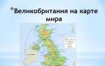
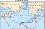
The Kuril Islands are a chain of islands between the Kamchatka Peninsula and the Japanese island of Hokkaido, separating the Sea of Okhotsk from the Pacific Ocean. They are part of the Sakhalin Region. Their length is about 1200 km. Total area - 10.5 thousand sq. km. There is a state border to the south of them. Russian Federation with Japan. The islands form two parallel ridges: the Big Kuril and the Small Kuril. Includes 30 large and many small islands. They are of great military-strategic and economic importance.
The territory of the North Kuril urban district includes the islands of the Great Kuril ridge: Atlasova, Shumshu, Paramushir, Antsiferova, Makanrushi, Onekotan, Harimkotan, Chirinkotan, Ekarma, Shiashkotan, Raikoke, Matua, Rasshua, Ushishir, Ketoy and all small islands... The administrative center is Severo-Kurilsk.
The southern Kuril Islands include the Iturup, Kunashir islands / belong to the Great Kuril ridge /, Shikotan and the Habomai ridge / belong to the Lesser Kuril ridge /. Their total area is about 8.6 thousand square meters. km.
Iturup, located between the islands of Kunashir and Urup, is the largest island in the Kuril archipelago in terms of area. Area - 6725 sq. km. The population is about 6 thousand people. Administratively, Iturup is part of the Kuril urban district. The center is the city of Kurilsk. The fishing industry forms the basis of the island's economy. In 2006, the most powerful fish factory in Russia "Reidovo" was launched on the island, processing 400 tons of fish per day. Iturup is the only place in Russia where a rhenium metal deposit has been discovered; since 2006, gold deposits have been explored here. Burevestnik airport is located on the island. In 2007, within the framework of the Federal Target Program, the construction of a new international airport Iturup, which will become the main air harbor in the Kuril Islands. Currently, the runway is being assembled.
Kunashir is the southernmost of the Kuril Islands. Area - 1495.24 sq. km. The population is about 8 thousand people. Center - urban-type settlement Yuzhno-Kurilsk / population 6.6 thousand people /. It is part of the South Kuril urban district. The main industry is fish processing. The entire territory of the island is a border zone. Civil and military transportation on the island is carried out by Mendeleevo Airport. For several years, reconstruction was carried out there in order to improve the air traffic of Kunashir with the neighboring islands of the Kuril ridge, Sakhalin and other Russian regions. On May 3, 2012, a permit was obtained to put the airport into operation. The work was carried out in accordance with the Federal Target Program "Social and Economic Development of the Kuril Islands / Sakhalin Oblast / for 2007-2015." As a result of the project, the airfield was reconstructed to receive An-24 aircraft, and the airport's engineering support was brought up to the requirements of the OGEA and FAP standards.
On Iturup and Kunashir, the only large unit of the Russian Armed Forces on the islands of the Kuril ridge is stationed - the 18th machine-gun and artillery division.
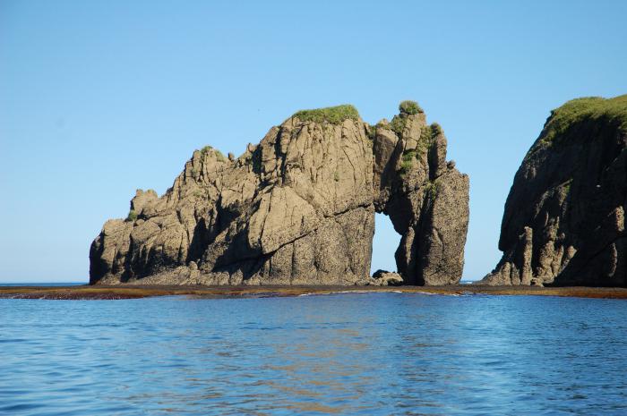
On the islands of Kunashir and Iturup, under the influence of the Kuril volcanic zone, volcanoes of different sizes stretch. Countless rivers, waterfalls, hot springs, lakes, meadows and bamboo can be attractive for tourism development on the islands.
Shikotan is the largest island in the Small Range of the Kuril Islands. Area - 225 sq. km. Population - more than 2 thousand people. It is part of the South Kuril urban district. Administrative center - with. Malokurilskoe. There is a hydrophysical observatory on the island, fishing and hunting for marine animals are also developed here. Shikotan is partly located on the territory of the state nature reserve of federal significance "Small Kuriles". The island is separated by the South Kuril Strait from Kunashir Island.
Habomai is a group of islands that, together with Shikotan Island, forms the Small Kuril Ridge. The Habomai include the islands of Polonsky, Oskolki, Zeleny, Tanfilyev, Yuri, Demina, Anuchin and a number of small ones. Area - 100 sq. km. It is part of the South Kuril urban district. The straits between the islands are shallow, filled with reefs and underwater rocks. There are no civilians on the islands - only Russian border guards.
In the chain of islands between Kamchatka and Hokkaido, stretching in a convex arc between the Sea of Okhotsk and the Pacific Ocean, on the border of Russia and Japan are the South Kuril Islands - the Habomai group, Shikotan, Kunashir and Iturup. These territories are contested by our neighbors, who even included them in the Japanese prefecture. Since these territories are of great economic and strategic importance, the struggle for the South Kuriles has been going on for many years.
Geography
Shikotan Island is located at the same latitude as the subtropical city of Sochi, and the lower ones are at the latitude of Anapa. However, a climatic paradise has never been here and is not expected. The South Kuril Islands have always belonged to the Far North region, although they cannot complain about the same harsh Arctic climate. Here winters are much milder and warmer, summers are not hot. This temperature regime, when in February - the coldest month - the thermometer rarely shows below -5 degrees Celsius, even the high humidity of the sea location deprives it of a negative effect. The monsoon continental climate here changes significantly, since the close presence of the Pacific Ocean weakens the influence of the equally close Arctic one. If in the north of the Kuril Islands in summer +10 on average, then the South Kuril Islands are constantly warming up to +18. Not Sochi, of course, but not Anadyr either.
The ensimatic arc of the islands is located at the very edge of the Okhotsk Plate, above the subduction zone where the Pacific Plate ends. For the most part, the South Kuril Islands are covered with mountains, on the Atlasov Island the largest peak is more than two thousand meters. There are also volcanoes, since all the Kuril Islands lie in the Pacific Ring of Fire. Seismic activity is also very high here. Thirty-six of the sixty-eight active volcanoes in the Kuril Islands require constant monitoring. Earthquakes are almost constant here, after which there is a danger of the world's largest tsunamis. Thus, the islands of Shikotan, Simushir and Paramushir have repeatedly suffered greatly from this element. The tsunamis of 1952, 1994 and 2006 were especially large.

Resources, flora
In the coastal zone and on the territory of the islands themselves, reserves of oil, natural gas, mercury, and a huge number of non-ferrous metal ores have been explored. For example, near the Kudryavy volcano there is the world's richest known rhenium deposit. Also, the southern part of the Kuril Islands was famous for the extraction of native sulfur. Here the total resources of gold are 1,867 tons, and there are also a lot of silver - 9,284 tons, titanium - almost forty million tons, iron - two hundred seventy-three million tons. Now the development of all minerals is waiting for better times, they are too few in the region, except for such a place as South Sakhalin. The Kuril Islands can generally be considered as a resource reserve of the country for a rainy day. Only two straits of all the Kuril Islands are navigable all year round because they do not freeze. These are the islands of the South Kuril ridge - Urup, Kunashir, Iturup, and between them - the Catherine and Frisa straits.
In addition to minerals, there are many other riches that belong to all mankind. This is the flora and fauna of the Kuril Islands. It varies greatly from north to south, since their length is quite large. In the north of the Kurils there is rather sparse vegetation, and in the south there are coniferous forests of amazing Sakhalin fir, Kuril larch, and ayan spruce. In addition, broad-leaved species are very active in the covering of island mountains and hills: curly oak, elms and maples, Kalopanax lianas, hydrangeas, actinidia, lemongrass, wild grapes and much, much more. There is even a magnolia on Kushanir - the only wild species of obovate magnolia. The most common plant that adorns the South Kuril Islands (landscape photo is attached) is the Kuril bamboo, whose impenetrable thickets hide from the eyes the slopes of the mountains and forest edges. The grasses here are very high and varied due to the mild and humid climate. There are a lot of berries that can be mined on an industrial scale: lingonberry, crowberry, honeysuckle, blueberry and many others.

Beasts, birds and fish
On the Kuril Islands (the northern ones are especially different in this regard), there are about the same number of brown bears as in Kamchatka. In the south, it would have been the same if not for the presence of Russian military bases. The islands are small, the bear lives close to the rockets. But especially in the south, there are a lot of foxes, because there is an extremely large amount of food for them. Small rodents - a huge number and many species, there are also very rare ones. From terrestrial mammals there are four orders: bats (brown long-eared bat, bat), hares, mice and rats, predators (foxes, bears, although there are few of them, mink and sable).
Sea mammals in the coastal island waters are inhabited by sea otters, anthurs (this is a species of island seal), sea lions and seals. A little further from the coast there are many cetaceans - dolphins, killer whales, minke whales, northern swimmers and sperm whales. Aggregations of eared sea-lion seals are observed along the entire coast of the Kuril Islands, especially a lot of them in the season. In the season here you can see colonies of fur seals, bearded seals, seals, lionfish. decoration of sea fauna - sea otter. The precious fur-bearing animal was on the verge of extinction in the very recent past. Now the situation with the sea otter is gradually leveling off. Fish in coastal waters is of great commercial value, but there are also crabs, and molluscs, and squids, and trepangs, all crustaceans, seaweed. The population of the South Kuril Islands is mainly engaged in fishing for seafood. In general, this place can be called without exaggeration one of the most productive areas in the World Ocean.
Colonial birds make up huge and picturesque bird colonies. These are fulmars, storm petrels, cormorants, various gulls, kitties, guillemots, puffins and many, many more. There are also many Red Book, rare - albatrosses and petrels, mandarin duck, osprey, golden eagles, eagles, peregrine falcons, gyrfalcons, Japanese cranes and snipe, eagle owls. Duck mallards, teals, gogols, swans, mergansers, eagles hibernate on the Kuril Islands. Of course, there are also many common sparrows and cuckoos. On Iturup alone there are more than two hundred species of birds, of which one hundred are nesting ones. Eighty-four species from those listed in the Red Book live in.

History: seventeenth century
The problem of belonging to the South Kuril Islands did not appear yesterday. Before the arrival of the Japanese and Russians, the Ainu lived here, who greeted new people with the word "kuru", which meant - a person. The Russians picked up the word with their inherent humor and called the aborigines "Kuril". This is where the name of the entire archipelago came from. The Japanese were the first to draw up maps of Sakhalin and all the Kuriles. This happened in 1644. However, the problem of the ownership of the South Kuril Islands arose even then, because a year earlier other maps of this region were compiled by the Dutch led by de Vries.
The lands have been described. But it is not true. The Frieze, after which the strait he discovered is named, attributed Iturup to the northeast of Hokkaido, and Urup considered it part of North America... A cross was erected on Urup, and all this land was declared the property of Holland. And the Russians came here in 1646 with the expedition of Ivan Moskvitin, and the Cossack Kolobov with the funny name Nekhoroshko Ivanovich later colorfully talked about the bearded Ainu inhabiting the islands. The following, slightly more extensive information came from the Kamchatka expedition of Vladimir Atlasov in 1697.

Eighteenth century
The history of the South Kuril Islands suggests that the Russians really came to these lands in 1711. The Kamchatka Cossacks rebelled, killed their superiors, and then changed their minds and decided to earn forgiveness or die. Therefore, they assembled an expedition for a hike to new unexplored lands. Danila Antsiferov and Ivan Kozyrevsky with a detachment in August 1711 landed on the northern islands of Paramushir and Shumshu. This expedition provided new knowledge about a whole range of islands, including Hokkaido. In this regard, in 1719, Peter the First entrusted intelligence to Ivan Evreinov and Fyodor Luzhin, through whose efforts a whole chain of islands was declared Russian territories, including the island of Simushir. But the Ainu, naturally, did not want to submit and go under the rule of the Russian tsar. Only in 1778, Antipin and Shabalin managed to convince the Kuril tribes, and about two thousand people from Iturup, Kunashir and even Hokkaido passed into Russian citizenship. And in 1779, Catherine II issued a decree exempting all new Eastern subjects from any taxes. And even then, conflicts began with the Japanese. They even banned Russians from visiting Kunashir, Iturup and Hokkaido.
The Russians did not have real control here yet, but the lists of lands were drawn up. And Hokkaido, despite the presence on its territory japanese city, was recorded as belonging to Russia. The Japanese, on the other hand, have been to the south of the Kuriles a lot and often, for which the local population justly hated them. The Ainu really lacked the strength to revolt, but little by little they hurt the invaders: either the ship would be sunk, or the outpost would be burned. In 1799, the Japanese had already organized the protection of Iturup and Kunashir. Although the Russian fishermen settled there relatively long ago - around 1785-87 - the Japanese rudely asked them to leave the islands and destroyed all evidence of the presence of the Russians on this land. The history of the South Kuril Islands already then began to acquire intrigue, but no one knew at that time how long it would be. For the first seventy years - until 1778 - the Russians did not even meet the Japanese in the Kuril Islands. The meeting took place in Hokkaido, which at that time was not yet conquered by Japan. The Japanese came to trade with the Ainu, and here the Russians are already catching fish. Naturally, the samurai got mad, began to shake their weapons. Catherine sent a diplomatic mission to Japan, but the conversation did not work out even then.

Nineteenth century - a century of concessions
In 1805, the famous Nikolai Rezanov tried to continue negotiations on trade, who arrived in Nagasaki and failed. Unable to endure the shame, he instructed two ships to make a military expedition to the South Kuril Islands - disputed territories stake out. It turned out a good revenge for the destroyed Russian trading posts, burned ships and expelled (those who survived) traders. A number of Japanese trading posts were destroyed, and a village on Iturup was burned down. Russian-Japanese relations have come to the last pre-war brink.
Only in 1855 was the first real delineation of territories made. Northern islands- Russia, southern - Japan. Plus joint Sakhalin. It was a pity to give up the South Kuril Islands, rich in crafts, especially Kunashir. Iturup, Habomai and Shikotan also became Japanese. And in 1875 Russia received the undivided ownership of Sakhalin for the cession of all the Kuril Islands to Japan without exception.
Twentieth century: defeats and victories
In the Russian-Japanese war of 1905, Russia, despite the heroism shown by the worthy songs of cruisers and gunboats, who were defeated in an unequal battle, lost, along with the war, half of Sakhalin - the southern, most valuable. But in February 1945, when victory over Nazi Germany was already predetermined, the USSR set a condition for Great Britain and the United States: it would help defeat the Japanese if the territories belonging to Russia were returned: Yuzhno-Sakhalinsk, the Kuril Islands. The Allies made a promise, and in July 1945 the Soviet Union reaffirmed its commitment. Already at the beginning of September, the Kuril Islands were completely occupied by Soviet troops. And in February 1946, a decree was issued on the formation of the Yuzhno-Sakhalin region, which included the Kurils in full force, which became part of Khabarovsk Territory... This is how the return of South Sakhalin and the Kuril Islands of Russia took place.
Japan was forced to sign a peace treaty in 1951, which stated that it did not claim and would not claim rights, legal grounds and claims regarding the Kuril Islands. And in 1956 The Soviet Union and Japan was preparing for signing the Moscow Declaration, which confirmed the end of the war between these states. As a sign of goodwill, the USSR agreed to hand over to Japan two Kuril Islands: Shikotan and Habomai, but the Japanese refused to accept them due to the fact that they did not refuse claims to other southern islands - Iturup and Kunashir. Here again they influenced the destabilization of the situation in the United States, when they threatened, if this document was signed, not to return the island of Okinawa to Japan. That is why the South Kuril Islands are still disputed territories.

Today's twenty-first century
Today, the problem of the South Kuril Islands is still relevant, despite the fact that a peaceful and cloudless life has long been established in the entire region. Russia is cooperating with Japan quite actively, but from time to time the conversation about the Kuril Islands comes up. In 2003, a Russian-Japanese action plan was adopted concerning cooperation between the countries. The presidents and prime ministers exchange visits, and numerous Russian-Japanese friendship societies of various levels have been created. However, all the same claims are constantly presented by the Japanese, but not accepted by the Russians.
In 2006, a whole delegation from public organization popular in Japan - the League of Solidarity for the Return of Territories. In 2012, however, Japan abolished the term "illegal occupation" in relation to Russia in matters relating to the Kuril Islands and Sakhalin. And in the Kuril Islands, the development of resources continues, federal programs for the development of the region are being introduced, the amount of funding is increasing, a zone with tax incentives has been created there, the islands are visited by the highest government officials of the country.
The problem of belonging
How can you not agree with the documents signed in February 1945 in Yalta, where the conference of the countries participating in the anti-Hitler coalition decided the fate of the Kuriles and Sakhalin, which will return to Russia immediately after the victory over Japan? Or did Japan not sign the Potsdam Declaration after signing its own Act of Surrender? I signed it after all. And it clearly states that its sovereignty is limited to the islands of Hokkaido, Kyushu, Shikoku and Honshu. Everything! On September 2, 1945, this document was signed by Japan, and therefore the conditions that were listed there were confirmed.
And on September 8, 1951, a peace treaty was signed in San Francisco, where she renounced in writing all claims to the Kuril Islands and Sakhalin Island with the adjacent islands. This means that its sovereignty over these territories, obtained after the Russian-Japanese war of 1905, is no longer valid. Although here the United States acted extremely insidiously, adding a very cunning clause, because of which the USSR, Poland and Czechoslovakia did not sign this treaty. This country, as always, did not keep its word, because it is in the nature of its politicians to always say "yes", but some of these answers will mean "no". The United States left a loophole in the treaty for Japan, which, after slightly licking its wounds and releasing, as it turned out, paper cranes after the nuclear bombings, renewed its claims.

Arguments
They were as follows:
1. In 1855, the Kuril Islands were included in the original possession of Japan.
2. The official position of Japan is that the Chishima Islands are not part of the Kuril chain, so Japan did not abandon them by signing an agreement in San Francisco.
3. The USSR did not sign the San Francisco treaty.
So, Japan's territorial claims are made on the South Kuril Islands of Habomai, Shikotan, Kunashir and Iturup, whose total area is 5175 square kilometers, and these are the so-called northern territories belonging to Japan. In contrast, Russia says on the first point that the Russo-Japanese War annulled the Shimoda Treaty, on the second point - that Japan signed a declaration on the end of the war, which, in particular, says that two islands - Habomai and Shikotan - the USSR is ready give back after signing a peace treaty. On the third point, Russia agrees: yes, the USSR did not sign this paper with a clever amendment. But there is no country as such, so there is nothing to talk about.
At one time with the USSR, it was somehow inconvenient to talk about territorial claims, but when it collapsed, Japan plucked up courage. However, apparently, even now these inclinations are in vain. Although in 2004 the Foreign Minister said that he agreed to talk about the territories with Japan, nevertheless, one thing is clear: no change in the ownership of the Kuril Islands can occur.
which opens only to the one
who is really interested in her ...
Kurile Islands.
Archipelago volcanic islands on the border of the Sea of Okhotsk and the Pacific Ocean, between the island of Hokkaido and the Kamchatka Peninsula (Sakhalin Region). Consists of the Big and Small Kuril ridges, separated by the Kuril straits. The islands form an arc long. OK. 1175 km. Total area 15.6 thousand km? The largest islands of the Big Kuril Ridge: Paramushir, Onekotan, Simushir, Urup, Iturup, Kunashir. Small Kuril ridge consists of 6 islands and two groups of rocks; the largest about. Shikotan.
Each island is a volcano or a chain of volcanoes, connected by foothills or separated by small isthmuses. The shores are mostly steep, sandy on the isthmuses, there are few sheltered bays. The islands are mountainous, with heights of 500-1000 m, the Alaid volcano (Atlasov Island in the north of the ridge) rises up to 2339 m. On the islands approx. 160 volcanoes, including 40 active, many thermal springs, there are strong earthquakes.
The climate is monsoon. Wed the temperature in August is from 10 ° C in the north to 17 ° C in the south, in February -7 ° C. Annual precipitation is 600-1000 mm, typhoons are frequent in autumn. There are many lakes, including craters and lagoons. Sowing. the islands are overgrown with alder and mountain ash, dwarf cedar and heather, on the islands cf. groups - sparse forests of stone birch with Kuril bamboo, to the south. islands - forests of Kuril larch, bamboo, oak, maple.
Remarks on the Kuril Islands "V. M. Golovnin, 1811
In 1811, the outstanding Russian navigator Vasily Mikhailovich Golovnin was commissioned to describe the Kuril and Shantar Islands and the coast of the Tatar Strait. In the course of this assignment, he, along with other sailors, was captured by the Japanese, where he spent more than 2 years. We invite you to familiarize yourself with the first part of his note "Remarks on the Kuril Islands", which was compiled on the basis of research in the same 1811.
1. About their number and names
If all the islands located between Kamchatka and Japan are understood as the Kuril Islands, then their number will be 26, namely:
1. Alaid
2. Shumshu
3. Paramushir
4. Fly
5. Makan-Rushi
6. Onekotan
7. Harimkotan *
8. Shnyashkotan **
9. Ekarma
10. Chirinkotan ***
11. Musir
12. Raikoke
13. Matua
14. Rasshua
15. Middle Island
16. Ushisir
17. Ketoy
18. Seamusir
19. Trebungo-Tchirpoy
20. Yangi-Tchirpoy
21. Mackintor **** or Broton Island
22. Urup
23. Iturup
24. Chicotan
25. Kunashir
26. Matsmai
Here is the real account of the Kuril Islands. But the Kuril people themselves and the Russians visiting them count only 22 islands, which they call: the first, the second, etc., and sometimes by their own names, which are:
Shumshu first island
Paramushir II
Fly third
Makan-Rusi fourth
Onekotan fifth
Harimkotan sixth
Shnyashkotan seventh
Ekarma eighth
Chirinkotan ninth
Musir tenth
Raikoke eleventh
Matua twelfth
Rasshua thirteenth
Ushisir fourteenth
Ketoy fifteenth
Seamusir sixteenth
Tchirpoy seventeenth
Urup eighteenth
Iturup nineteenth
Chicotan 20th
Kunashir twenty first
Matsmay twenty-second
The reason for this difference in the number of islands is the following: neither the Kuril Islands, nor the Russians living in that region, Alaid is considered the Kuril Island, although in all respects it belongs to this ridge. The Trebungo-Tchirpoi and Yangi-Tchirpoi islands are separated by a very narrow strait and the almost naked small island of Mackintor, or Broton Island, located not far from them to NW, is understood by the general name of the seventeenth island and, finally, the island of Sredniy, almost connected to Ushisir by a ridge of surface and pitfalls, they do not consider a special island. So, with the exception of these four islands, there are 22 islands that are somehow usually relied on in the Kuril ridge.
It is also known that in different descriptions and on different maps of the Kuril Islands, some of them are called differently: this dissimilarity came from error and ignorance. Here it will not be superfluous to mention under what names some of the Kuril Islands are known on the best foreign maps and in the description of Captain Kruzenshtern.
Musir Island, otherwise called by the inhabitants of the Steller's Stones, Captain Kruzenshtern calls the Stone Traps.
He calls Raikoke Musir, Matua - Raikoke, Rasshua - Matua, Ushisir - Rasshua, Ketoy - Ushisir, Simusir - Ketoy, and on foreign maps they write him as Marikan.
After La Perouse, the French call Tchirp the Four Brothers.
Urup is written by foreigners as Kompaneiskaya Zemlya, and the Russian American Company calls it Alexander Island.
Iturup on foreign maps is called the Land of the States. Chicotan, or Spanberg Island. Matsmai, or the Land of Esso.
--


The Alaid island mentioned in the text is Atlasov Island, which got its modern name in 1954 - the Alaid volcano island. It is an almost regular volcano cone, with a base diameter of 8-10 km. Its peak lies at 2339 m. (According to historical data, before the strong eruptions of 1778 and 1821, the height of the volcano was much higher), which means that Alaid is high volcano Kuril ridge.
We draw your attention to the fact that the 26th island of the Kuril ridge is called the island of Matsmai - this is Hokkaido. Hokkaido became part of Japan only in 1869. Until that time, the Japanese lived only on the southern tip of the island, where there was a small Japanese principality. The rest of the territory was inhabited by the Ainu, who even outwardly differed sharply from the Japanese: white-faced, with strong hair, for which the Russians called them "furry smokers". It is known from documents that at least in 1778-1779, Russians collected yasak from the inhabitants of the northern coast of Hokkaido.

The largest of the Kuril Islands in the direction from north to south: Shumshu - 467 square kilometers,

Paramushir - 2479 square kilometers,

Onekotan, or Omukotan, - 521 square kilometer,

Harimkotan - 122 square kilometers,

Shiyashkotan - 179 square kilometers,

Seamusir - 414 square kilometers,

Urup - 1511 square kilometers, Iturup, the largest of the Kuril Islands - 6725 square kilometers.

Kunashir Island - 1548 square kilometers

and Chicotan or Scotan - 391 square kilometers.
Island Shikotan- this is the end of the world. Just 10 km from the village of Malokurilskoye, behind a small pass lies its main attraction - Cape Krai Sveta. ... Russian navigators Rikord and Golovnin called him Fr. Chicotan.

Small islands are located from north to south: Alaid - 92 square kilometers (Atlasov Island), Shirinki, Makanrushi or Makansu - 65 square kilometers, Avos, Chirinkotan, Ekarma - 33 square kilometers, Musir, Raikoke, Malua or Matua - 65 square kilometers ... Islands: Rasshua - 64 square kilometers, Ketoi - 61 square kilometers, Broughtona, Chirpoi, Brother Chirpoev, or Brother Hirnoy, (18 square kilometers). Between the islands from the Sea of Okhotsk to the east to the Pacific Ocean there are straits: the Kuril Strait, the Small Kuril Strait, the Nadezhda Strait, the Diana Strait, the Bussolip Strait of De Vries and the Pico Strait.
The entire range of the Kuril Islands is of volcanic origin. There are 52 volcanoes in total, including 17 active ones. There are many hot and sulfur springs on the islands;
earthquakes .
The Ainu - the peoples inhabiting the Kuril Islands, christened each island separately. These are the words of the Ainu language: Paramushir is a wide island, Onekotan is an old settlement, Ushishir is a land of bays, Chiripoy is a bird, Urup is a salmon, Iturup is a large salmon, Kunashir is a black island, Shikotan is the best place... Beginning in the 18th century, the Russians and the Japanese tried to rename the islands in their own way. Most often, serial numbers were used - the first island, the second, etc.; only the Russians counted from the north, and the Japanese from the south.
The Kuril Islands are administratively part of the Sakhalin Region. They are divided into three regions: Severo-Kurilskiy, Kurilskiy and Yuzhno-Kurilskiy. The centers of these regions have corresponding names: Severo-Kurilsk, Kurilsk and Yuzhno-Kurilsk. And there is one more village - Malo-Kurilsk (the center of the Lesser Kuril ridge). A total of four Kurilsk.

Kunashir Island.
A MEMORARY SIGN OF RUSSIAN PILOTS WAS ESTABLISHED ON KUNASHIR |
|
A memorial sign in honor of the 230th anniversary of the landing of Russian Cossacks-pioneers under the leadership of Dmitry Shabalin was opened on September 3 in the village. Golovnino (South Kuril region, Kunashir). It was installed near the rural house of culture.
The well-known Sakhalin historian-archaeologist Igor Samarin discovered documents and the so-called "mercator map" of the Kuril Islands, drawn up based on the results of the voyage of 1775-1778. near Kunashir. There is an inscription on it: "... D where were the Russian people in two canoes in 778". The "D" icon is depicted at the site of the current location with. Golovnino - near the Strait of Treason (southern part of the island). The historical fact real place the landing of Russians on the coast of Kunashir was proved by Russian scientists. The expedition was headed by the Irkutsk merchant D. Shabalin.
|