The deepest fjord in the world. Norwegian fjords
What are the fjords of Norway
The word fjord can be literally translated as a bay. It is in Norway that their number is the largest. If we take into account only the main fjords without branches, then there are 97 of them. And the most amazing thing is that each fjord has its own unforgettable landscape and its own history. Some of them are several tens of meters long, while others extend for tens of kilometers.
The appearance of fjords in Norway is due to 2 reasons:
- As a result of tectonic movements of the earth's crust, a break in the crust occurs and a fjord appears in its place.
- After the ice age, ice floes began to come down, collecting and dragging huge boulders with them. As a result, the structure of the earth's surface changed and the unique bays of Norway appeared.
To get to know all the fjords, you need to travel around the country for several months, which is quite difficult. Therefore, you can see all the beauty of nature by visiting the most famous of the fjords. In order to find them, you need to hit the road along the roads leading from the cities of Bergen and Alesund.

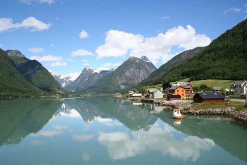
It is unique for its size. Sognefjord is honorably ranked second in the list of the largest fjords in the world. It is as long as 204 km, and maximum depth is equal to 1308 meters. The fjord is located near the city of Bergen.
The landscape of the fjord is very rich: this is majestic mountains with snow caps, and endless meadows, and breathtaking waterfalls. Tourists can visit the Sognefjord either by cruise ship or by walking or cycling.

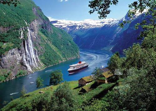
Compared to the endless Sognefjord, the Geirangerfjord seems quite small. After all, its length is all 20 km. But even despite its small size, it is still considered the most visited fjord by tourists.
Already in 2006, the Geirangerfjord was included in the UNESCO list. Tourists can not only enjoy scenic spot but also fishing, rafting and kayaking.
There is a real threshold to heaven on this fjord, where the most best view... Fjord waterfalls also delight tourists.

And this fjord is considered the narrowest in Norway. The rocks surrounding it seem to embrace the waters of the bay. According to legend, the fjord is named after the god Njord, who fell in love with this bay for its picturesque landscapes... God liked the sea fjord much more than the endless seas and oceans, and he began to protect it.
Nareufjord is located 150 km from Bergen. When you reach it, you can walk along royal trail, see a stunning panorama from observation deck Stegastein and visit the real Viking village - Gudvangen.
Remember our journey through glacial lake Moiraine of incredible beauty? So today we will visit a similar fairy tale! Mountains, forests, crystal pure water will surprise us today. And our today's trip will be no less interesting and magical. We will visit the fjords of Norway - the most beautiful mountain bays and enjoy the beauty of nature.
Where are the fjords of Norway
But before talking about the most beautiful mountain bays in Norway, let's answer the question: what are fjords? The fjord is a narrow bay with rocky cliffs where the length exceeds the width. By the way, no less.

Everyone knows that if we start talking about Norway as a whole, we cannot but mention the most beautiful mountain bays themselves. After all, it was these unusual formations that cut into the northern coast of Norway in particular. They leave the impression of some kind of fairy tale. Quiet, calm, the most beautiful mountain fairy tale.

Fjords are located in the north of the country and fascinate everyone with their grandeur. This is truly something extraordinary and fabulous. They are fraught with something unique. Their power and greatness make one believe that beauty mountain ranges, the tranquility of the bays and the fresh scent of forests can be magical and mesmerizing.

How and when the Norwegian fjords formed
This beauty appeared here due to the fact that a very long time ago, about 11 thousand years ago, the glacier moved away and formed these amazing mountain bays. Soil erosion also helped. Years passed, and the beauty of this area only increased.

By the way, from the Norwegian language "fjord" is translated as "bay".

The most beautiful mountain bays in Norway
The fjords are called the pearl and business card of Norway. Their beauty has attracted and continues to attract tourists from all over the world. the globe.

The majestic mountains and the most quiet, most beautiful mountain bays seem to beckon with their unearthly beauty.

Being here, in this wonderful place, you immediately forget about all the problems of life.

And Geiranger Fjord and Nэрrøy Fjord became the property of UNESCO. The first became famous amazing waterfalls and incredibly beautiful landscapes. The second one is the narrowest: the length reaches 1700 meters, and the width is 300 meters.

By the way, the local area is also famous for its beautiful waterfalls. This place is full of unusualness and fabulousness. Coming here, you will find yourself in a real fairy tale.

You look at the rocks of Norway - and immediately light goosebumps will run through your body. Here you want to embrace the immensity, to stay forever. All problems here become just dust. Nobody needs and absolutely useless dust. In short, the fjords of Norway are a real fairy tale that you should definitely visit.

Travel around incredible places the globe and relax with us.
Where are the Norwegian fjords located on the map

An amazing country. It is impossible to gaze at her without aspiration. majestic nature... In winter, it is restrained and harsh, and in the short northern summer it blooms with pure and rich emerald colors. Norwegian fjords can be considered a national treasure of the country. These are picturesque sea bays, cutting into the rocky coast and stretching tens of kilometers inland. Millions of tourists come to see them every year. The best angle is from the water.
During a boat trip, a breathtaking view of the steep slopes, from which waterfalls rush, opens up. At first, the traveler is surrounded by green hills and mountains, but gradually snow-covered peaks appear on the horizon. In a word, an unforgettable sight.
Previous photo 1/ 1 Next photo
Which fjords are worth visiting?
There are thousands of fjords in Norway that dot the entire western part of the Scandinavian Peninsula. But mostly a dozen of the most famous and most accessible are visited, among which everyone knows the Sognefjord, Geirangerfjord, Hardangerfjord and Lysefjord. Of course, the infrastructure around the bays is excellently developed. It is easy to reach them by transport from the nearest cities; there are comfortable hotels and restaurants in the fishing villages on the shores. If a tourist wants to see all this beauty from the water, then at his service are ferries, pleasure boats and even cruise ships... On land equipped observation decks where the highways lead.
Previous photo 1/ 1 Next photo

Fjord tours and excursions
Organized fjord tours in Norway in most cases start from Oslo. The programs of the agencies are different, but most often they involve inspecting the bays both from water and from land. The cost of travel for 6-7 days is from 1000 EUR per person (excluding the road to Oslo, plane tickets are paid for independently). This amount also includes breakfast. If you go by ferry from St. Petersburg, it will be cheaper - from 300 EUR per person. But this is a fee only for accommodation in 2-3 local cabins, transfers between cities / towns by buses and basic excursion services.
Previous photo 1/ 1 Next photo

Self visit
Independent travelers will have to use by public transport... This almost always involves multiple transfers. For example, to see the Preikestolen rock and get to
Cliffs that rise directly from the water are very popular with tourists from all over the world, as well as snowy peaks and abundantly vegetated mountains. These slopes are called fjords. They are part of the natural landscape. There are also "special territories" on the Internet. One such special area is the Howling Fjord. It is located in the southeast of Northrend (World of Warcraft), at the very top of the Great Sea.
Origin of natural rocky bays
Often, hearing the word "fjord" in a conversation, not every person understands what is at stake. Let's take a little look at this issue. So, the fjord - the term is customary to call a long sea bay cut into the land with the surrounding rocky shores. Usually the length of the fjord is tens of times its width. It has cliffs reaching a height of 1000 meters. The origin of the fjords is due to a sharp change in the movement of tectonic plates. The result is the formation of numerous faults and cracks, which are subsequently filled. sea water... Such fjords are most often characterized by a considerable depth, in some cases reaching 800 meters.

The most famous rocky bays in the world
So, to the question: "fjord - what is it?" we partially answered. But for those who still have a bad idea of what this is about, we will give examples. The most famous are 4 districts with fjord formations. These include the coast of Chile, North America, Norway and These places are the most visited by tourists. In addition, there are fjords on the shores of Iceland, Russia, Scotland, and the Arabian Peninsula. They can even be found near some of the Arctic islands.

The longest rocky bay in the world
Fjords of norway
What are these rocky formations? How are they remarkable? Many have heard about it many times. So let's dwell on this point in more detail. It turns out that the second largest rocky bay is located in Norway. The Sognefjord (this is the name of this massif) is the largest in Europe, its length is 204 km. Royal fjord capital - Oslo - unique and distinctive city Scandinavia. It is located in the depths of a 107 km long rocky bay. 8 rivers flow through the city, in addition, it is surrounded by 343 lakes and 40 islands. Anyone who wishes can admire the splendor of the beaches and untouched nature, just take a ferry to one of the islands. Norway is famous for the most picturesque and majestic rocky formations, no wonder its second name is the Land of Fjords.

The most visited bay
This place should be discussed separately. The most visited Gulf of Norway is the Geiranger Fjord. It is located in the province of Mere og Rumsdal, about 100 km from the city of Ålesund. When traveling to this corner of wildlife, be sure to visit the famous observation decks on the Fludalsjuve ridge and on Dalsnibba Mountain. In addition, one should not deny oneself the pleasure of performing walk... But most importantly, don't miss the opportunity to swim in these waters! For tourists (and not only) there is an opportunity to take a cruise on a boat and admire the wonderful waterfalls from its side. "Seven Sisters" or "Bridal Veil" are very picturesque.
Eagles road
Describing this fjord (which is what is said above), one should especially talk about the Eagles Road - the steepest road section on the terrain. This path is a serpentine. To get from the Geiranger Fjord coast to the highest point of the mountain by transport, you need to overcome 11 extremely sharp turns. This is a journey for thrill-seekers. The highest point is 620 meters above sea level. From there, you can take simply stunning photographs of the surroundings. For these purposes, as well as just to get acquainted with the area, special observation platforms have been equipped. The most famous among them are "Fludalsjuve" and "Dalsnibba". They are included in the list of the most famous and visited attractions in the region.

History Center
It is located about a kilometer from the center of Geiranger. Here tourists have a unique opportunity to study the history of this region, as well as get acquainted with its nature and local residents, their morals and customs. You can choose to go for an easy walk and conquer the local mountain peak... It offers simply stunning views. Those who decide to take a risk and go to the mountains should definitely visit the "Haiking". This place has many trails, which are not only marked, but also provided with excellent maps of the area. Lovers of easy walks can take a trip to a small village located on south side fjord. The road to it runs along the coast of a rocky bay and is 2.5 km long. There is a small but very cozy cafe in the village where you can taste wonderful homemade food local cuisine... Those wishing to learn more about the local nature and the surrounding area should visit the Vasteras farm. Here it is famous waterfall"Sturseterfossen". You can walk between the seething stream and the rock, the sensations are indescribable!
Most Popular Attractions
Tourists have a unique opportunity to visit the local farm "Herdalssetra". It is also located in the Geirangerfjord. The uniqueness of this trip is that the mentioned farm is located in Nurddal. This region is included in the list of the World natural heritage UNESCO. Also, tourists can watch the process of making caramel and cheese from goat's milk. Another attraction that also attracts the attention of guests is Mountain road"Trollstegen". It is she who is considered the most picturesque, since it is surrounded by peaks rushing into the sky. For lovers alpine skiing should go to this wonderful place in winter. Vacationers will be able to descend from a height of 1500 meters directly to the coast. But those who are on vacation in the summer should not be upset. You also have the option of skiing. At the beginning of the season, summer opens here. ski center, exact time opening depends on the thickness of the snow cover. Now you shouldn't have any questions about the meaning of the word "fjord". What is this, we theoretically found out in the article. For a practical understanding, you must definitely visit such a place at least once in your life.
February 23rd, 2014, 05:39 pm
In general, the expression "Homeless tour to Norway" sounds like an oxymoron, because Norway, if not the most, is definitely in the top 5 most expensive countries in Europe. And the French say that people who can afford to travel to this northern country, everything is in order with finances. Of course, I would argue with that - we krimhilda_konig I have been there, so I dare to give some advice to those who want to see the fjords on a budget. I think that 380 euros for 5 days in Norway is very good. And if you exclude souvenirs and hitchhike - and even cheaper. I will make a reservation: we did not have a goal to see EVERYTHING, because we were going to Norway for the first, but not the last time. According to the plan: the city of Stavanger, the Preikestolen and Kjerag rocks.

(50 photos)
Route: bus Kaliningrad-Gdansk 850 r. in both directions, plane Gdansk-Stavanger 1500 rub. in both directions, plus luggage (1 suitcase for two) 2000 rub. Road transport around the city costs 170 rubles, but within an hour and a half you can go back along it. This helped us save finances several times.
On the plane to Norway, you must definitely sit by the window - the views of the country: the islands, mountains, houses, are fantastic.

Once again, we were convinced that couchsurfing is a great thing: our “oil tycoons”, as we called the guys who host us, work as engineers in oil offices. Employers rent houses for them, in which the kitchen alone is larger than my whole rental apartment... For 5 days we changed two places of residence: we lived with the Swede Hannes and the Brazilian Marcelo. Not only were they very nice, but they also fed us dinner, or rather, two dinners. And Marcelo left us the keys as he left for the weekend.

We brought Russian vodka and amber to our hosts. They also fried potato pancakes. In general, we brought with us half a suitcase of products bought in Poland: cheeses, pâtés, sausages, crackers, etc. Eating in Norwegian cafes is sooo expensive, in supermarkets a kilogram of tomatoes costs 200 rubles, so we only allowed ourselves to buy shrimps (150 r. / kg). I think it's a good replacement: :)
Stavanger is a city of white houses. In the old town, you want to hug each house, they are so beautiful.

And there is also a no less beautiful street of colorful houses. In one of them, if I am not mistaken, there is a museum.

Seagulls, impudent creatures, devoured us, snatching sandwiches.

The water at the pier is clear and you can see many beautiful jellyfish in it.

Stavanger is the oil capital of Norway, so there is an oil museum (entrance - 550 rubles). We were not interested in him, as well as the Museum of Canned Food and Television Museums)

A 30-minute drive from the city center, on the banks of the Hafrsfjord, stands the Swords in the Stone monument, erected in memory of the battle that took place here in 872. The swords themselves are rather large - under 10 meters.


So, the second day in Norway, and we go to the Preikestolen rock to see this:

I must say right away that it was an epic file of our trip and an instructive lesson for the future. So, everyone does not go to Stavanger to watch swords for several days and cuddle with white wooden houses. The main goal is to see the Lysefjord, namely: climb the Preikestolen cliff (pulpit), see "one of the most breathtaking views in the world" according to the Lonely planet guide, take a boat ride along the fjord, and, of course, jump on the rock the Kjeragbolton stone and place a bow on it. We weren't original, so we didn't think about the program for a long time.
Already in the morning the weather told us that it was a bad idea - it was drizzling outside and it was foggy. But Hannes checked the weather at the foot of the cliff - they promised 25 degrees Celsius and sunshine.


10 a.m. We come to the Stavanger-Chow ferry - there are no people at all (I had to think again). I decided to ask a woman, a ferry worker, whether it was worth going in such weather. So, the question is why I was interested in this, if her answer did not affect our further actions in any way ?! The lady advised us not to go. "What if it clears up?" - we thought and boarded the ferry. The cost of the trip is about 50 kroons, and when I handed the controller a 50-kroon piece of paper, he said - uh, it's Swedish! Oops, thank you, dear Sberbank for such a currency exchange.
In general, beautiful views could be opened from the ferry. Could, but did not openJ
In Chow you need to change to a bus, the price of which seems to be 80 CZK. Upon arrival at the foot of the Preikestolen cliff, we met a couple who were going to go back in this bus. "Have you already gone to the rock?" - “No, what are you? What's the point? You won't see anything anyway. " What if! - we thought for the second time. The rain began to intensify, so Maya bought herself a raincoat, but I must say, they were of no use. We are inexperienced hikers - we did not have suitable clothes and shoes, and it would be stupid to buy for one trip, so I went to Norway with sneakers from the first year and a raincoatH&
M.
For a minute the fog cleared away (hope dawned), but after a moment the sky was overcast again, and the rain became even stronger.
Honestly, I was bored and wrote to my friend suffering sms. Maya, on the other hand, remained calm and said: "Okay, let's get to the first platform and go down." When we saw people climbing the mountains with babies, we realized that we must stop whining and wait for good weather and go up.
The diagram shows the route - about 4 km in one direction in a straight line, but in fact you go much more, because the road goes uphill. The height of the destination is 640 m above sea level.
Even at the beginning of the journey, we met advanced hikers who were already descending from Preikestolen, they once again said that it was better not to go there in our shoes, especially since you could not see anything from above. Well, you know what we thought as we continued on our way. 

In order not to get lost, the letters T are painted on the stones with red paint, probably this meanstrek, but this is just my guess. On this day, the road looked like this, and we walked on the water. The sneakers glided on the wet stones.

In some places, the road turned into waterfalls, and we climbed over wet stones, holding onto neighboring, equally wet, stones.
The bridges over the mountain rivers were washed away, so they had to wade - the sneakers could be squeezed out. And in general (who would doubt it), Converse sneakers are far from the best footwear for hiking in the mountains, but we met a group of tourists, shod in ballet flats and moccasins, almost with clutches in their hands. Well, guess what country these women were from ?!) It's a pity, at that moment we had no time for photographing

We were soaked to our underwear, and walking in such clothes was so unpleasant for me that I could not find anything better than changing trousers for shorts. Not only did I look like a Russian vagabond rather than a tourist in this form, but I also immediately suffered, slipping on wet stones. And here is the result of J

Only in a couple of places were there fences, in the rest, slipping and falling from a half-kilometer height was like nothing to do.

Bleeding, we continued our way and after 3 hours we saw the outlines of the cliff. For comparison - what we should have seen, judging by the photographs from the Internet.


What we saw in the end - NOTHING!


At first we almost cried, then hysterics began, and we were laughing stupidly. In the end, at the top, we ate a sandwich, drank a mug of tea and hurried back. I forgot my thermos there, so I'll probably go back there again. This inscription, left by someone who was more fortunate, looked especially mocking.

Maya: “Katya, when I want to go to the mountains again, remind me of Preikestolen” - “Yes, Maya, I will remind you tomorrow” - in a day we had to go hiking to Kjerag.
The last full day in Norway, and the last chance for Norway to rehabilitate itself in our eyes. Today we drive to the Kjerag plateau, which is pronounced Schjørag in Norwegian. We bought a ticket from Stavanger in advance, paying 490 kroons. You can get to Kjerag in two ways - either by car or by special sightseeing buses. Although what kind of excursion they are? During the trip, the driver told us only a few phrases about the places we passed, that's the whole tour. All they do is take you to the foot of the mountain and back to Stavanger, and, of course, no one will tell you about the history of the stones along the way while hiking.
If everything goes well (pah-pah-pah), then we will stand on a round pebble and see the fjord in all its glory. 
(photo from the Internet)
In order not to get a second epic fail and not to run headlong in the morning in search of a stop, in the evening we walked to the pier to see where there is a bus... We did not find any signposts, but Marcelo later convinced us that we would not miss the bus, no matter how we tried. Approaching the pier, we realized - yes, try not to find this bus: at this time (at 7 in the morning) it is there alone, and all around is silence and emptiness. The bus should leave at 7-30, but it's good that we arrived early, since there were not enough seats for everyone, some of them went standing up toSandnes, where they were transferred to a minibus. Standing on Norwegian buses ?! How can this be at all! If in Scandinavia every passenger needs to buckle up, otherwise you can fly in at 200 euros for each.
The road to the plateau is already one continuous attraction - a serpentine mountain, on the sides - hills, lakes, rocks.

And also - fog. Yes, damn fog. The driver said that the weather will be fine today and the fog will clear soon. We can only hope for the favor of the Norse gods 
The bus made its first stop in a village with a difficult to pronounce name (in general, in Norwegian, all rural settlements are difficult to pronounce). There Maya drank coffee, and I went to photograph butting goats living in the territory adjacent to the cafe.

In the program of the "tour" it was stated that the departure from the final point at 16-45, and we arrive there at about 11 in the morning. We asked the driver if we had enough time for everything. He said that he spent 5 hours hiking back and forth, and an hour for stopping and photographing above the rooftop. The answer did not seem comforting to me, and suspicions crept into my head that we would not be in time, but since I drove there 5 times a week, it means that he knows everything better than we do.
The final stop is at the foot of Mount Kjerag. Downstairs there is a house with a cafeteria, sheep and lambs are running around the site - everyone has a bell and tags on their ears. In general, there are a lot of lambs here, so bells are ringing everywhere. Moreover, they graze everywhere in the mountains, and not in some kind of fenced area. 
All arriving at Kjerag are greeted by a board with a map of the place and a reminder of the rules of conduct. So, the distance from the place where we are to Kjerag is 5 km, but this is in a straight line, and a "walk" with three ascents and descents awaits us, and this is more than 10 km. V this moment we are at an altitude of 640 m, and highest point- 1080 m.

Hiking to Kjerag is described as hard, only recommended for experienced guys. Well, we climbed into a rainstorm and fog on Preikestolen, on slippery stones, we all have already become experimental! Ehhhh, if we knew then what awaits us - Preikestolen turned out to be "ugh, nonsense for kids" in comparison with Kjerag.
About halfway through the first ascent, I said, "Maya, next time I want to go to the mountains, remind me of Kjerag." The road to the first rock is almost vertical - we covered the entire distance, holding onto the chains along the edges. In some places the chains were broken ... I wonder what happened to the people who at that moment were holding on to these chains. And the metal stakes that hold the chains are often bent at right angles. View from the first mountain -Lille Stordalen- opened onto a gorgeous mountain valley, the fjord was not yet visible, but it was already breathtaking from such beauty.

Further downhill, which is sometimes harder than uphill, because there are mountain streams, and the stones around are wet, and therefore the sneakers, like mine, begin to slip. By the way, they served their purpose and were thrown into the trash when they returned to the city.
And here is the second peak - 890 meters -Stordalen... We rise, get up, look around and see him - Lysefjord! Emerald water and the village of Lysebotn, it seems to be at home for three :) And we tried to find an entry there and wondered why it was on the sitecouchsurfing no one is registered there.Only workers of local power plants live there.

On the way we met a fellow countryman - Oleg from St. Petersburg, and, by the way, for the first time I was very glad to meet a Russian person abroad. It turned out that he had moved to Stavanger for work, he came to Kjerag alone by car, so he kindly offered to take us back to the city. We said yes, if we can't catch the bus.
The weather this time was not that good and warm, but hot to such an extent that we burned out - none of us thought that we should take to Norway sunscreen... In mountain lakes, of course, the water is cold (but not much more than in our Baltic Sea in the middle of summer), but I still got into the water, quickly swam ashore. M By the way, there is still snow, so it's hard not to play snowballs while wearing shorts and T-shirts.

The pointer tells us where the same Kjerag Bolton pea is.

For many who come here, the main goal is to climb this stone, and since it was a warm Sunday afternoon, the queue was serious. So, if we had not met Oleg, either we would not have stood on a stone, or we would have missed the bus - 6 hours would obviously not have been enough for us to calmly explore the entire plateau and stay in one place for more than a couple of minutes. Although we are not entirely anti-sports ladies - I ride my bike to work every dayJ, so we had some kind of physical training and endurance. But we also saw families with small children, a couple were even with babies, there were also dogs.

And here he is - Kjeragbolton. It's better to be three of us, like us. Oleg and Maya took a place in the queue, and at that time I was on duty at the place from where everyone was taking photographs, at the same time I watched who jumped on the stone. One lady pulled the dog there, the guy (turned out to be Russian) jumped on the stone altogether - at that moment I already screamed: "Nooo!"


After completing my mission and having photographed Oleg, I joined Maya. In fact, standing there, waiting seemed more terrifying to me than jumping on a stone. It is wide enough, there is enough space on it for both two and three, but a slight thrill and excitement is still felt. No matter how much I searched the Internet, I could not find information about whether anyone fell from Kjeragbolton. We were still thinking, how about in winter? In the same place, I suppose, slip on the ice stone and fall - just spit. It's simple - the road to the Kjerag plateau is open only in warm weather, in winter - only by water to the village of Lysebotn, so climbers use this option. But I could be wrong.

Where can I go without it - I'm on a stone :) 
But base jumpers did crash, yes. There was a cup at the top with names and surnames - either the dead base jumpers, or those who made some record jumps.

We explored the surroundings, sat on the edge of the plateau, admired the picturesque views from the mountain, and headed back. We did it - Norway, you are completely rehabilitated in our eyes, so we will come again: we have to climb onto the Troll's tongue.


